
-
Federal
IBEX High Energy Neutral Atom Imager (ENA-Hi) Data Release 10, not Compton-Getting corrected, not Survival Probability corrected, Antiram direction, West Longitude Ecliptic Maps, Level H3 (H3), 7 year average Data
National Aeronautics and Space Administration —
The IBEX ENA-Hi and IBEX ENA-Lo data sets are from Release 10 of all-sky map data for the first seven years, 2009-2015, in the form of antiram direction Hydrogen, H,... -
Federal
IBEX High Energy Neutral Atom Imager (ENA-Hi) Data Release 10, Compton-Getting corrected, Survival Probability corrected, Ram direction, West Longitude Ecliptic Maps, 1 year averaged data, Level H3
National Aeronautics and Space Administration —
This IBEX-Hi data set is from Release 10 of all-sky map data for the first seven years, 2009-2015, in the form of ram direction Hydrogen, H, energetic neutral atom... -
Federal
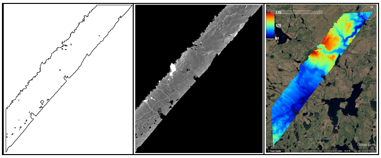
ABoVE: AirSWOT Ka-band Radar over Surface Waters of Alaska and Canada, 2017
National Aeronautics and Space Administration —
This dataset provides AirSWOT (Surface Water and Ocean Topography) Ka-band (35.75 GHz) radar data products collected from an airborne platform over parts of Alaska... -
Federal
IBEX High Energy Neutral Atom Imager (ENA-Hi) Data Release 10, Compton-Getting corrected, not Survival Probability corrected, Omnidirectional, West Longitude Ecliptic Maps, Level H3 (H3), 7 year average Data
National Aeronautics and Space Administration —
The IBEX ENA-Hi and IBEX ENA-Lo data sets are from Release 10 of all-sky map data for the first seven years, 2009-2015, in the form of omni direction Hydrogen, H,... -
Federal
IBEX High Energy Neutral Atom Imager (ENA-Hi) Data Release 10, Compton-Getting corrected, Survival Probability corrected, Omnidirectional, West Longitude Ecliptic Maps, 6 month averaged data, Level H3
National Aeronautics and Space Administration —
This IBEX-Hi data set is from Release 10 of all-sky map data for the first seven years, 2009-2015, in the form of omni direction Hydrogen, H, energetic neutral atom... -
Federal
IBEX High Energy Neutral Atom Imager (ENA-Hi) Data Release 10, Compton-Getting corrected, Survival Probability corrected, Antiram direction, West Longitude Ecliptic Maps, Level H3 (H3), 7 year average Data
National Aeronautics and Space Administration —
The IBEX ENA-Hi and IBEX ENA-Lo data sets are from Release 10 of all-sky map data for the first seven years, 2009-2015, in the form of antiram direction Hydrogen, H,... -
Federal
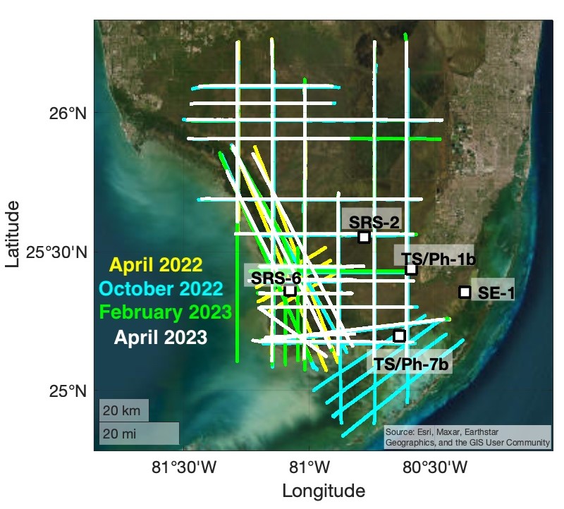
BlueFlux Airborne Trace Gases, Fluxes, and Mixing Ratios, Southern Florida, 2022-2023
National Aeronautics and Space Administration —
This dataset includes airborne in situ measurements of greenhouse gas mixing ratios, meteorological parameters, and fluxes (CO2, CH4, latent heat fluxes, friction... -
Federal
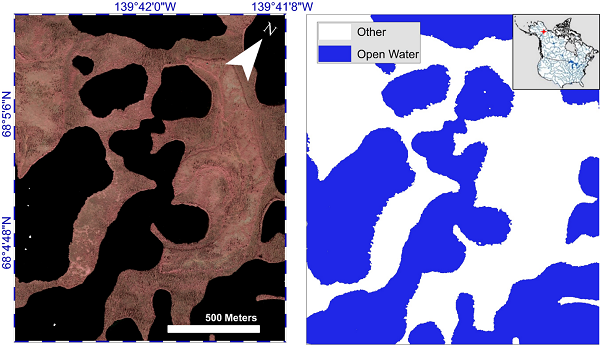
ABoVE: AirSWOT Water Masks from Color-Infrared Imagery over Alaska and Canada, 2017
National Aeronautics and Space Administration —
This dataset provides 1) a conservative open water mask for future water surface elevation (WSE) extraction from the co-registered AirSWOT Ka-band interferometry... -
Federal
TROPICS03 L2B Atmospheric Vertical Temperature and Moisture Profiles (AVTP, AVMP) V1.0
National Aeronautics and Space Administration —
The "Time-Resolved Observations of Precipitation structure and storm Intensity with a Constellation of Smallsats" (TROPICS) mission has a goal of providing nearly... -
Federal
TRMM (TMPA-RT) Near Real-Time Microwave precipitation estimate L3 3 hour 0.25 degree x 0.25 degree V7 (TRMM_3B40RT) at GES DISC
National Aeronautics and Space Administration —
TMPA (3B40RT) dataset have been discontinued as of Dec. 31, 2019, and users are strongly encouraged to shift to the successor IMERG datasets (doi:... -
Federal
IBEX High Energy Neutral Atom Imager (ENA-Hi) Data Release-13, Compton Getting, no Survival Probability, Antiram direction, West Ecliptic Pressure and Flux Power Law Slope Maps, Level H3 (H3), annually averaged Data
National Aeronautics and Space Administration —
The IBEX ENA-Hi data sets are from Release 13 of all-sky map data for the first ten years, 2009-2018, in the form of ram direction Hydrogen, H, energetic neutral atom... -
Federal
IBEX High Energy Neutral Atom Imager (ENA-Lo) Data Release 10, not Compton-Getting corrected, not Survival Probability corrected, Omnidirectional, West Longitude Ecliptic Maps, Level H3 (H3), 7 year average Data
National Aeronautics and Space Administration —
The IBEX ENA-Hi and IBEX ENA-Lo data sets are from Release 10 of all-sky map data for the first seven years, 2009-2015, in the form of omni direction Hydrogen, H,... -
Federal
IBEX High Energy Neutral Atom Imager (ENA-Hi) Data Release 10, Compton-Getting corrected, not Survival Probability corrected, Omnidirectional, West Longitude Ecliptic Maps, 6 month averaged data, Level H3
National Aeronautics and Space Administration —
This IBEX-Hi data set is from Release 10 of all-sky map data for the first seven years, 2009-2015, in the form of omni direction Hydrogen, H, energetic neutral atom... -
Federal
Million Quasars Catalog (MILLIQUAS), Version 8 (2 August 2023)
National Aeronautics and Space Administration —
This table contains the Million Quasars (MILLIQUAS) Catalog, Version 8 (2 August 2023). It is a compendium of 907,144 type-I QSOs and AGN, largely complete from the... -
Federal
MODIS/Terra+Aqua AOD and Water Vapor from MAIAC, Daily L3 Global 0.05Deg CMG V061
National Aeronautics and Space Administration —
The MCD19A2CMG Version 6.1 data product is a Moderate Resolution Imaging Spectroradiometer (MODIS) Terra and Aqua combined Multi-Angle Implementation of Atmospheric... -
Federal
IBEX High Energy Neutral Atom Imager (ENA-Hi) Data Release 10, not Compton-Getting corrected, not Survival Probability corrected, Omnidirectional, West Longitude Ecliptic Maps, Level H3 (H3), 7 year average Data
National Aeronautics and Space Administration —
The IBEX ENA-Hi and IBEX ENA-Lo data sets are from Release 10 of all-sky map data for the first seven years, 2009-2015, in the form of omni direction Hydrogen, H,... -
Federal
IBEX High Energy Neutral Atom Imager (ENA-Hi) Data Release 10, not Compton-Getting corrected, Survival Probability corrected, Antiram direction, West Longitude Ecliptic Maps, Level H3 (H3), 7 year average Data
National Aeronautics and Space Administration —
The IBEX ENA-Hi and IBEX ENA-Lo data sets are from Release 10 of all-sky map data for the first seven years, 2009-2015, in the form of antiram direction Hydrogen, H,... -
Federal
IBEX High Energy Neutral Atom Imager (ENA-Hi) Data Release 10, not Compton-Getting corrected, Survival Probability corrected, Omnidirectional, West Longitude Ecliptic Maps, Level H3 (H3), 7 year average Data
National Aeronautics and Space Administration —
The IBEX ENA-Hi and IBEX ENA-Lo data sets are from Release 10 of all-sky map data for the first seven years, 2009-2015, in the form of omni direction Hydrogen, H,... -
Federal
IBEX High Energy Neutral Atom Imager (ENA-Hi) Data Release 10, not Compton-Getting corrected, not Survival Probability corrected, Ram direction, West Longitude Ecliptic Maps, 1 year averaged data, Level H3
National Aeronautics and Space Administration —
This IBEX-Hi data set is from Release 10 of all-sky map data for the first seven years, 2009-2015, in the form of ram direction Hydrogen, H, energetic neutral atom... -
Federal
IBEX High Energy Neutral Atom Imager (ENA-Hi) Data Release 10, not Compton-Getting corrected, Survival Probability corrected, Omnidirectional, West Longitude Ecliptic Maps, 6 month averaged data, Level H3
National Aeronautics and Space Administration —
This IBEX-Hi data set is from Release 10 of all-sky map data for the first seven years, 2009-2015, in the form of omni direction Hydrogen, H, energetic neutral atom...

Official websites use .gov
A
.gov website belongs to an official government
organization in the United States.
Secure .gov websites use HTTPS
A
lock (
) or https:// means you’ve safely connected to
the .gov website. Share sensitive information only on official,
secure websites.