
-
Federal
GPM IMERG Final Precipitation L3 1 day 0.1 degree x 0.1 degree V07 (GPM_3IMERGDF) at GES DISC
National Aeronautics and Space Administration —
Version 07 is the current version of the data set. Older versions will no longer be available and have been superseded by Version 07.The Integrated Multi-satellitE... -
Federal
Global Food Security-support Analysis Data (GFSAD) Cropland Extent-Product 2015 Validation 30 m V001
National Aeronautics and Space Administration —
The NASA Making Earth System Data Records for Use in Research Environments (MEaSUREs) Global Food Security-support Analysis Data (GFSAD) data product provides... -
Federal
Combined GPS Broadcast Ephemeris Data (30-second sampling, hourly files) from NASA CDDIS
National Aeronautics and Space Administration —
This dataset consists of ground-based Global Navigation Satellite System (GNSS) Combined Broadcast Ephemeris Data (hourly files of all distinct navigation messages... -
Federal
SWOT Sword of Science River Discharge Products Version 1
National Aeronautics and Space Administration —
The SWOT Sword of Science River Discharge Products dataset from the Surface Water and Ocean Topography (SWOT) mission and produced by the Discharge Algorithm Working... -
Federal
MODIS/Aqua Near Real Time (NRT) 5-min Spacecraft attitude data from GBAD to be read via SDP Toolkit Binary Format
National Aeronautics and Space Administration —
PM1ATTNR is the Aqua Near Real Time (NRT) daily spacecraft attitude data file in native format. This is MODIS Ancillary Data. The data collection consists of PM1... -
Federal
NACP North American Forest Dynamics Project: Forest Disturbance and Regrowth Data
National Aeronautics and Space Administration —
This data set provides the results of time-series analyses of Landsat imagery for 55 selected forested sites across the conterminous U.S.A. The output is a pair of... -
Federal
VEMAP 2: U.S. Daily Climate Change Scenarios
National Aeronautics and Space Administration —
The Vegetation/Ecosystem Modeling and Analysis Project (VEMAP) Phase 2 has developed a number of transient climate change scenarios based on coupled atmosphere-ocean... -
Federal
Global Distribution of Root Turnover in Terrestrial Ecosystems
National Aeronautics and Space Administration —
Estimates of root turnover rates were calculated from measurements of live root standing crop and belowground net primary production (BNPP) compiled from the primary... -
Federal
NASA 3D Models: Helmet
National Aeronautics and Space Administration —
Astronaut’s helmet model. -
Federal
CALIPSO Lidar Level 3 Tropospheric Aerosol Profiles, Cloud Free Data, Standard V4-20
National Aeronautics and Space Administration —
CAL_LID_L3_Tropospheric_APro_CloudFree-Standard-V4-20 is the Cloud-Aerosol Lidar and Infrared Pathfinder Satellite Observation (CALIPSO) Lidar Level 3 Tropospheric... -
Federal
Spitzer Deep Wide-Field Survey 4.5 micron Epoch 4 Catalog
National Aeronautics and Space Administration —
The Spitzer Deep, Wide-Field Survey (SDWFS) is a four-epoch infrared survey of 10 square degrees in the Boötes field of the NOAO Deep Wide-Field Survey using the IRAC... -
Federal
MODIS/Terra Land Surface Temperature/Emissivity 8-Day L3 Global 1km SIN Grid V006
National Aeronautics and Space Administration —
The MOD11A2 Version 6 data product was decommissioned on July 31, 2023. Users are encouraged to use the MOD11A2 Version 6.1 data product.The MOD11A2 Version 6 product... -
Federal
VIIRS/NPP Daily Gridded Day Night Band 500m Linear Lat. Lon. Grid Night NRT
National Aeronautics and Space Administration —
The first of two Visible Infrared Imager Radiometer Suite (VIIRS) Day Night Band (DNB) based Near Real Time (NRT) datasets is a daily, top-of-atmosphere, at-sensor... -
Federal
MISR L2 FIRSTLOOK TOA/Cloud Stereo Product subset for the ARCTAS region V001
National Aeronautics and Space Administration —
ATSM2STF_001 is the Multi-angle Imaging SpectroRadiometer (MISR) Level 2 FIRSTLOOK TOA/Cloud Stereo Product subset for the ARCTAS region version 1. It contains the... -
Federal
CERES MODIS Cloud Retrievals in ISCCP-D2like Format Nit Terra FM1 Edition3A
National Aeronautics and Space Administration —
CER_ISCCP-D2like-Nit_Terra-FM1-MODIS_Edition3A is the Clouds and the Earth's Radiant Energy System (CERES) Moderate Resolution Imaging Spectroradiometer (MODIS) Cloud... -
Federal
TC4 AMPR BRIGHTNESS TEMPERATURE (TB) V1
National Aeronautics and Space Administration —
The TC4 AMPR Brightness Temperature (TB) dataset consists of brightness temperature data from July 19, 2007 through August 8, 2007. The Tropical Composition, Cloud... -
Federal
SatCORPS CERES GEO Edition 4 Meteosat-5 Full Disk Version 2
National Aeronautics and Space Administration —
CER_GEO_Ed4_MET05_FD_V02 is the Satellite Cloud and Radiation Property retrieval System (SatCORPS) Clouds and the Earth's Radiant Energy System (CERES) Geostationary... -
Federal
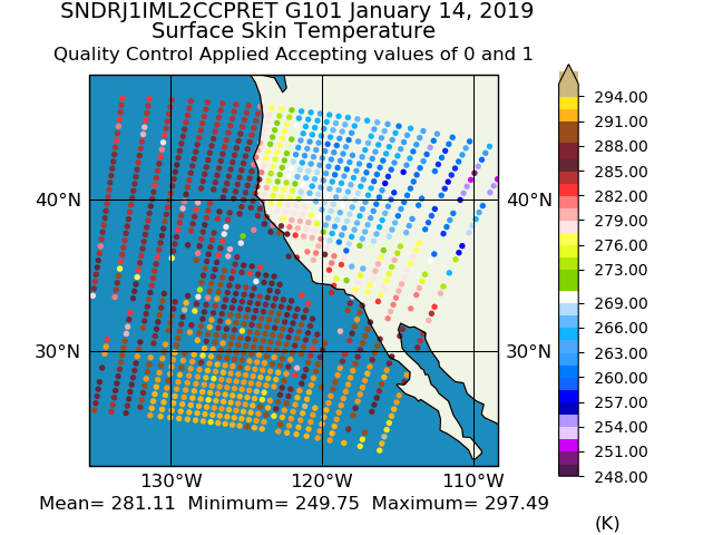
Sounder SIPS: JPSS-1 CrIS Level 2 CLIMCAPS: Atmosphere cloud and surface geophysical state V2 (SNDRJ1IML2CCPRET) at GES DISC
National Aeronautics and Space Administration —
WARNING: To users of the derived product “co_mmr_midtrop” (carbon monoxide mass mixing ratio to dry air [kg/kg] at ~500 hPa). This variable has a significant bias due... -
Federal
Tundra Plant Reflectance, CO2 Exchange, PAM Fluorometry, and Pigments, AK, 2001-2002
National Aeronautics and Space Administration —
This dataset provides measurements at tundra plots collected near Utqiagvik and Atqasuk, AK, including visible-near infrared spectral reflectance, chamber gas... -
Federal
GPM MHS on METOP-A (GPROF) Radiometer Precipitation Profiling L3 1 month 0.25 degree x 0.25 degree V07 (GPM_3GPROFMETOPAMHS_CLIM) at GES DISC
National Aeronautics and Space Administration —
Version 07 is the current version of the data set. Older versions are no longer available and have been superseded by Version 07. The "CLIM" products differ from...

Official websites use .gov
A
.gov website belongs to an official government
organization in the United States.
Secure .gov websites use HTTPS
A
lock (
) or https:// means you’ve safely connected to
the .gov website. Share sensitive information only on official,
secure websites.