
-
Federal
SBUV2/NOAA-18 Ozone (O3) Profile and Total Column Ozone 1 Month Zonal Mean L3 Global 5.0 degree Latitude Zones V1 (SBUV2N18L3zm) at GES DISC
National Aeronautics and Space Administration —
The Solar Backscattered Ultraviolet (SBUV) from NOAA-18 Level-3 monthly zonal mean (MZM) product (SBUV2N18L3zm) is derived from the Level-2 retrieved ozone profiles.... -
Federal
MRIR/Nimbus-3 Images of Daytime Brightness Temperature on 4 x 5 inch Film Sheets V001 (MRIRN3IM) at GES DISC
National Aeronautics and Space Administration —
MRIRN3IM is the Nimbus-3 Medium Resolution Infrared Radiometer (MRIR) data product consisting of 4 x 5 inch photographic film sheets. Each film sheet contains an... -
Federal
Soil Moisture Profiles and Temperature Data from SoilSCAPE Sites, USA
National Aeronautics and Space Administration —
This data set contains in-situ soil moisture profile and soil temperature data collected at 20-minute intervals at SoilSCAPE (Soil moisture Sensing Controller and... -
Federal
LBA Regional Mean Climatology, 0.5-Deg, 1930-1960, V. 2.1 (Cramer and Leemans)
National Aeronautics and Space Administration —
This data set is a subset of Cramer and Leemans' (2001) global database of mean monthly climatology, which contains monthly averages of mean temperature, temperature... -
Federal
TROPICS07 L2A Unified Resolution Brightness Temperatures V0.2
National Aeronautics and Space Administration —
The "Time-Resolved Observations of Precipitation structure and storm Intensity with a Constellation of Smallsats" (TROPICS) mission has a goal of providing nearly... -
Federal
SBUV2/NOAA-19 Ozone (O3) Profile and Total Column Ozone 1 Month Zonal Mean L3 Global 5.0 degree Latitude Zones V1 (SBUV2N19L3zm) at GES DISC
National Aeronautics and Space Administration —
The Solar Backscattered Ultraviolet (SBUV) from NOAA-19 Level-3 monthly zonal mean (MZM) product (SBUV2N19L3zm) is derived from the Level-2 retrieved ozone profiles.... -
Federal
CERES Daily Daytime Mean Regionally Averaged Terra and Aqua TOA Fluxes and Associated Cloud Properties Stratified by Optical Depth and Effective Pressure Edition4A
National Aeronautics and Space Administration —
CER_FluxByCldTyp-Day_Terra-Aqua-MODIS_Edition4A is the Clouds and the Earth's Radiant Energy System (CERES) Daily Daytime Mean Regionally Averaged Terra and Aqua Top-... -
Federal
LBA-ECO TG-07 Ground-based Biometry Data at km 83 Site, Tapajos National Forest: 1997
National Aeronautics and Space Administration —
Changes in the biomass of Amazon region forests represent an important component of the global carbon cycle but the biomass of these forests remains poorly... -
Federal
Sounder SIPS: AQUA AIRS IR-only Level 2 CLIMCAPS: retrieved atmospheric state V2.1 (SNDRAQIL2CPS) at GES DISC
National Aeronautics and Space Administration —
The CLIMCAPS (Community Long-term Infrared Microwave Coupled Product System) algorithm is used to analyze data from the AIRS (Atmospheric Infrared Sounder). The AIRS... -
Federal
LiDAR Derived Biomass, Canopy Height, and Cover for New England Region, USA, 2015
National Aeronautics and Space Administration —
This dataset provides 30 m gridded estimates of aboveground biomass density (AGBD), forest canopy height, and tree canopy coverage for the New England Region of the... -
Federal
MLS/Aura Level 3 Monthly Binned Ozone (O3) Mixing Ratio on Assorted Grids V004 (ML3MBO3) at GES DISC
National Aeronautics and Space Administration —
ML3MBO3 is the EOS Aura Microwave Limb Sounder (MLS) monthly binned on various vertical grids product for ozone (O3) derived from radiances measured by the 240 GHz... -
Federal
Sentinel-5P TROPOMI Near-Real-Time (NRT) Carbon Monoxide CO Column 1-Orbit L2 5.5km x 7km V2 (S5P_L2__CO_____HiR_NRT) at GES DISC
National Aeronautics and Space Administration —
The Sentinel-5P TROPOMI Near Real Time (NRT) Carbon Monoxide CO Column 1-Orbit L2 5.5km x 7km V2 (S5P_L2__CO_HiR_NRT) at GES DISC is the near real time version of the... -
Federal
MLS/Aura Level 3 Daily Binned Water Vapor (H2O) Mixing Ratio on Zonal and Similar Grids V004 (ML3DZH2O) at GES DISC
National Aeronautics and Space Administration —
ML3DZH2O is the EOS Aura Microwave Limb Sounder (MLS) daily binned on zonal and assorted vertical grids product for water vapor (H2O) derived from radiances measured... -
Federal
Global Vegetation Types, 1971-1982 (Matthews)
National Aeronautics and Space Administration —
The global vegetation type data of 1 x 1 degree latitude and longitude resolution were designed for use in studies of climate and climate change. Vegetation data were... -
Federal
CATS-ISS Level 2 Operational Day Mode 7.1 Version 3-01 5 km Layer
National Aeronautics and Space Administration —
CATS-ISS_L2O_D-M7.1-V3-01_05kmLay is the Cloud-Aerosol Transport System (CATS) International Space Station (ISS) Level 2 Operational Day Mode 7.1 Version 3-01 5 km... -
Federal
Rock glaciers, Zailiysiky Range, Kungei Ranges, Tienshan, Kazakhstan, Version 1
National Aeronautics and Space Administration —
The Zailiyskiy Alatau is the northernmost parallel latitudinal ranges of the Northern Tien Shan. The highest point of this range is the Talgar peak (4973 m a.s.l.).... -
Federal
Aircraft Flux-Detrended: Univ. Col. (FIFE)
National Aeronautics and Space Administration —
The NCAR King Air participation in FIFE-1987 and FIFE-1989 was part of a coordinated atmospheric boundary layer component which included other aircraft, surface... -
Federal
LBA Regional Global Historical Climatology Network, V. 1, 1832-1990
National Aeronautics and Space Administration —
This data set consists of a subset of the Global Historical Climatology Network (GHCN) Version 1 database for the study area of the Large Scale Biosphere-Atmosphere... -
Federal
LBA-ECO CD-08 Radiocarbon Dates for Large Trees from a Forest near Manaus, Brazil
National Aeronautics and Space Administration —
This data set reports the ages and growth rates of trees as determined by radiocarbon dating (14C), selected from a logging operation near the city of Itacoatiara,... -
Federal
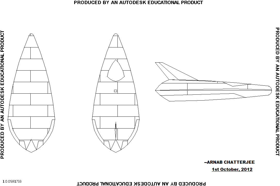
Single reusable spacecraft
National Aeronautics and Space Administration —
Design of a my single person reusable spacecraft. It can carry one person and it has to be dropped from an aircraft at an altitude of 40,000 - 45,000 feet. Can be the...

Official websites use .gov
A
.gov website belongs to an official government
organization in the United States.
Secure .gov websites use HTTPS
A
lock (
) or https:// means you’ve safely connected to
the .gov website. Share sensitive information only on official,
secure websites.