
-
Federal
MISR Level 2 Surface parameters V002 recent views
National Aeronautics and Space Administration —
MIL2ASLS_2 is the Multi-angle Imaging SpectroRadiometer (MISR) Level 2 Land Surface parameters version 2 data product. It contains a variety of information on the... -
Federal
BOREAS TE-08 Aspen Bark Chemistry Data recent views
National Aeronautics and Space Administration —
Contains bark biochemical data collected by TE-08. -
Federal
UARS Correlative UKMO Daily Gridded Stratospheric Assimilated Data V001 (UARZCUKM) at GES DISC recent views
National Aeronautics and Space Administration —
The UARS Correlative assimilation data from the U.K. Meteorological Office (UKMO) consists of daily model runs at 12:00 GMT as a means of providing an independent... -
Federal
UARS Improved Stratospheric and Mesospheric Sounder (ISAMS) Level 3AL V010 (UARIS3AL) at GES DISC recent views
National Aeronautics and Space Administration —
The Improved Stratospheric and Mesospheric Sounder (ISAMS) Level 3AL data product consists of daily, 4 degree increment latitude-ordered vertical profiles of... -
Federal
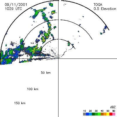
CAMEX-4 TOGA RADAR V1 recent views
National Aeronautics and Space Administration —
The TOGA radar dataset consists of browse and radar data collected from the TOGA radar during the CAMEX-4 experiment. TOGA is a C-band linear polarized doppler radar... -
Federal
GPM GROUND VALIDATION SATELLITE SIMULATED ORBITS TWP-ICE V1 recent views
National Aeronautics and Space Administration —
The GPM Ground Validation Satellite Simulated Orbits TWP-ICE dataset is available in the Orbital database, which takes account for the atmospheric profiles, the... -
Federal
UARS Improved Stratospheric and Mesospheric Sounder (ISAMS) Level 3AT V010 (UARIS3AT) at GES DISC recent views
National Aeronautics and Space Administration —
The Improved Stratospheric and Mesospheric Sounder (ISAMS) Level 3AT data product consists of daily, 65.536 second interval time-ordered vertical profiles of... -
Federal
UARS High Resolution Doppler Imager (HRDI) Level 3AT V011 (UARHR3AT) at GES DISC recent views
National Aeronautics and Space Administration —
The High Resolution Doppler Imager (HRDI) Level 3AT data product consists of daily, 65.536 second interval time-ordered vertical profiles of meridional and zonal wind... -
Federal
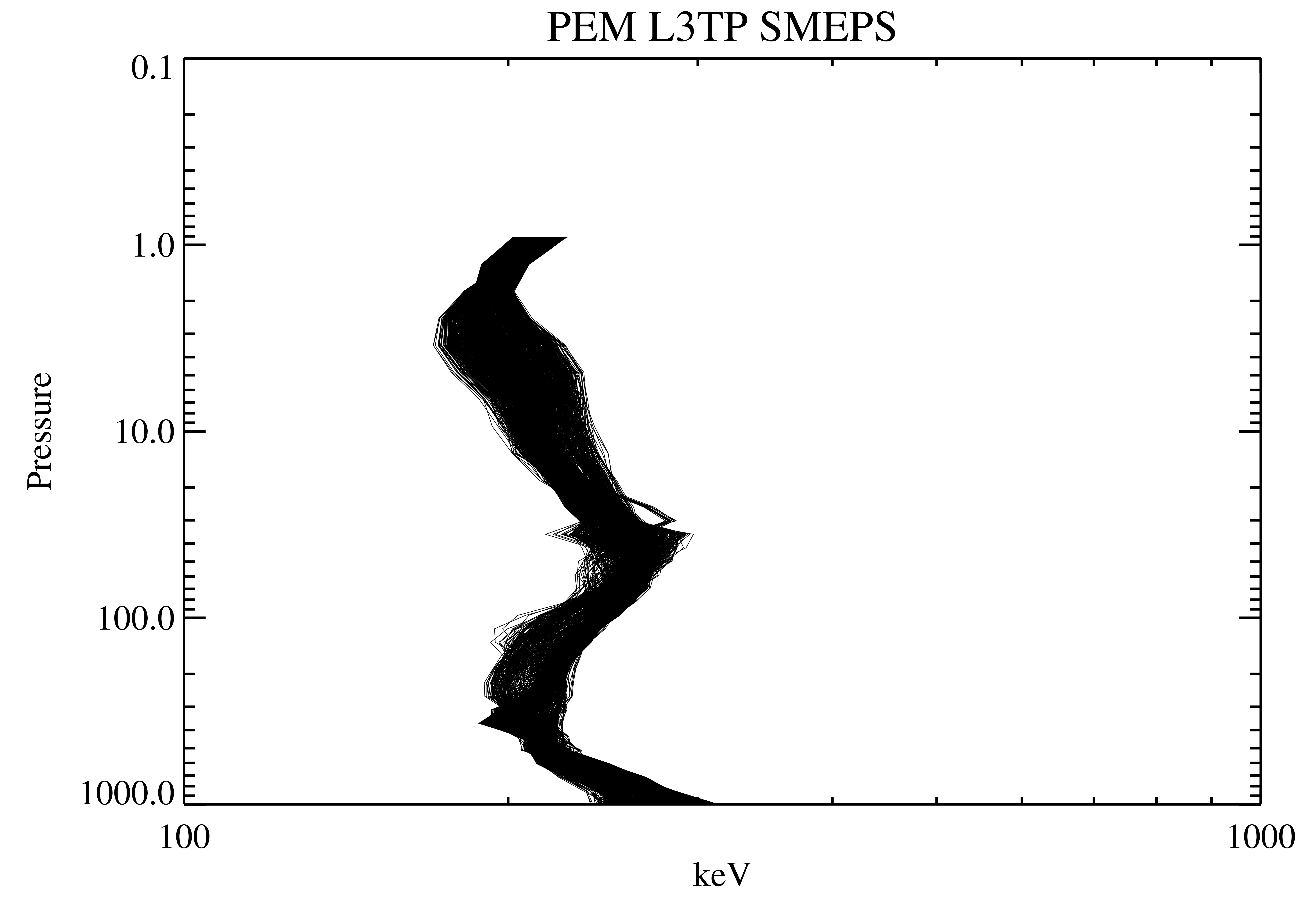
UARS Particle Environment Monitor (PEM) Level 3TP V004 (UARPE3TP) at GES DISC recent views
National Aeronautics and Space Administration —
The Particle Environment Monitor (PEM) Level 3TP data product consists of daily, 65.536 second and 2.048 interval time-ordered, vertical profiles of electron and... -
Federal
UARS Particle Environment Monitor (PEM) Level 3AT V004 (UARPE3AT) at GES DISC recent views
National Aeronautics and Space Administration —
The Particle Environment Monitor (PEM) Level 3AT data product consists of daily, 65.536 second interval time-ordered, vertical profiles of electron, proton and x-ray... -
Federal
BOREAS RSS-14 GOES-7 Level-1a Visible, Infrared, and Water Vapor Images recent views
National Aeronautics and Space Administration —
The level-1a BOREAS GOES-7 image data was collected by Remote Sensing Science Team-14 (RSS-14) personnel at Florida State University and processed to level-1a... -
Federal
BIGFOOT Meteorological Data for North and South American Sites, 1991-2004 recent views
National Aeronautics and Space Administration —
The BigFoot Project has compiled daily meteorological measurements for nine EOS Land Validation Sites located from Alaska to Brazil from 1991 to 2004. Each site is... -
Federal
BOREAS RSS-17 Stem, Soil, and Air Temperature Data recent views
National Aeronautics and Space Administration —
Contains the soil and stem temperature measurements collected by RSS17 at various flux sites: (1) Southern Study Area (SSA) at the Old Black Spruce (OBS), Old Jack... -
Federal
BOREAS TE-06 1994 Soil and Air Temperatures in the NSA recent views
National Aeronautics and Space Administration —
Contains soil temperature data collected by TE-06 during the BOREAS project. -
Federal
BOREAS Level-2 MAS Surface Reflectance and Temperature Images in BSQ Format recent views
National Aeronautics and Space Administration —
MAS images, along with other remotely sensed data, were collected to provide spatially extensive information over the primary study areas. This information includes... -
Federal
BOREAS Level-3S SPOT Imagery: Scaled At-Sensor Radiance in LGSOWG Format recent views
National Aeronautics and Space Administration —
For BOREAS, the level-3s SPOT data, along with the other remotely sensed images,were collected in order to provide spatially extensive information over the primary... -
Federal
BOREAS TE-18 Landsat TM Physical Classification Image of the NSA recent views
National Aeronautics and Space Administration —
The objective of this classification is to provide BOREAS investigators with a data product that characterizes the land cover of the NSA. A Landsat-5 TM image from... -
Federal
SAFARI 2000 SeaWiFS Images for the Southern African Region, 1999-2001 recent views
National Aeronautics and Space Administration —
This data set contains Sea-viewing Wide Field-of-view Sensor (SeaWiFS) imagery for the southern African region. These images are Level-1a swaths of the southern... -
Federal
Aircraft Flux-Filtered: NRCC (FIFE) recent views
National Aeronautics and Space Administration —
Filtered boundary layer fluxes recorded on aircraft flights over the Konza

Official websites use .gov
A
.gov website belongs to an official government
organization in the United States.
Secure .gov websites use HTTPS
A
lock (
) or https:// means you’ve safely connected to
the .gov website. Share sensitive information only on official,
secure websites.