
-
Federal
Global Gridded Geographically Based Economic Data (G-Econ), Version 4 recent views
National Aeronautics and Space Administration —
The Global Gridded Geographically Based Economic Data (G-Econ), Version 4 contains derived one degree grid cells of Gross Domestic Product (GDP) data in Grid and... -
Federal
Global Urban Polygons and Points Dataset (GUPPD), Version 1 recent views
National Aeronautics and Space Administration —
The Global Urban Polygons and Points Dataset (GUPPD), Version 1 is a global data set of 123,034 urban settlements with place names and population for the years... -
Federal
ASTER Global Digital Elevation Model V003 NGDA recent views
National Aeronautics and Space Administration —
The ASTER Global Digital Elevation Model (GDEM) Version 3 (ASTGTM) provides a global digital elevation model (DEM) of land areas on Earth at a spatial resolution of 1... -
Federal
Global Urban Heat Island (UHI) Data Set, 2013 recent views
National Aeronautics and Space Administration —
The Urban Heat Island (UHI) effect represents the relatively higher temperatures found in urban areas compared to surrounding rural areas owing to higher proportions... -
Federal
OSCAR third degree resolution ocean surface currents - yearly files recent views
National Aeronautics and Space Administration —
OSCAR (Ocean Surface Current Analysis Real-time) contains near-surface ocean current estimates, derived using quasi-linear and steady flow momentum equations. The... -
Federal
OMPS-NPP L2 NM Aerosol Index swath orbital recent views
National Aeronautics and Space Administration —
The OMPS-NPP L2 NM Aerosol Index swath orbital product provides aerosol index values from the Ozone Mapping and Profiling Suite (OMPS) Nadir-Mapper (NM) instrument on... -
Federal
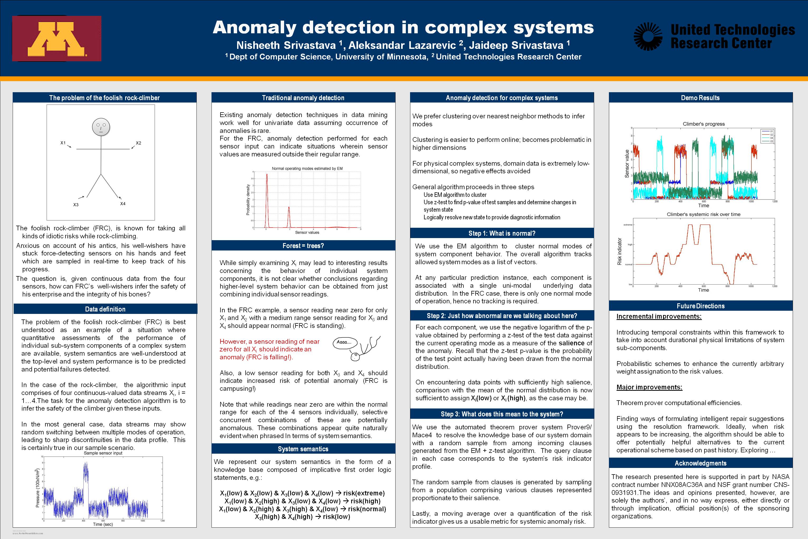
Anomaly Detection for Complex Systems recent views
National Aeronautics and Space Administration —
In performance maintenance in large, complex systems, sensor information from sub-components tends to be readily available, and can be used to make predictions about... -
Federal
SDG Indicator 9.1.1: Rural Access Index (RAI), 2023 Release recent views
National Aeronautics and Space Administration —
The SDG Indicator 9.1.1: The Rural Access Index (RAI), 2023 Release data set, part of the SDGI collection, measures the proportion of the rural population who live... -
Federal
JPL TELLUS GRACE-FO Level-3 Monthly Ocean Bottom Pressure Anomaly Release 6.3 version 04 recent views
National Aeronautics and Space Administration —
This data set is produced by the Jet Propulsion Laboratory (JPL) as part of the GRACE-FO (Gravity Recovery and Climate Experiment Follow-On) program and derives the... -
Federal
GPM Ground Validation Global Flood Monitoring System (GFMS) Flood Maps IFloodS V1 recent views
National Aeronautics and Space Administration —
The GPM Ground Validation Global Flood Monitoring System (GFMS) Flood Maps IFloodS dataset contains global flood estimates on a 0.25 degree spatial resolution every 3... -
Federal
CYGNSS L3 Ocean Microplastic Concentration V1.0 recent views
National Aeronautics and Space Administration —
This dataset contains the version 1.0 CYGNSS level 3 ocean microplastic concentration data record, which provides 18 netCDF files, each containing one month of daily... -
Federal
OMPS-NPP L1G LP Radiance EV Wavelength-Altitude Grid swath orbital 3slit V2.6 (OMPS_NPP_LP_L1G_EV) at GES DISC recent views
National Aeronautics and Space Administration —
The OMPS-NPP L1G LP Radiance EV Wavelength-Altitude Grid swath orbital 3slit product contains the calibrated earth-viewing radiances measured by the Ozone Mapping and... -
Federal
OSCAR 1 degree ocean surface currents recent views
National Aeronautics and Space Administration —
OSCAR (Ocean Surface Current Analysis Real-time) contains near-surface ocean current estimates, derived using quasi-linear and steady flow momentum equations. The... -
Federal
S-MODE MASS Level 1 Visible Imagery Version 1 recent views
National Aeronautics and Space Administration —
This dataset contains airborne visible imagery from the Sub-Mesoscale Ocean Dynamics Experiment (S-MODE) during a pilot campaign conducted approximately 300 km... -
Federal
Northwest Pacific Pre-SWOT Level-4 Hourly MITgcm LLC4320 Native Grid 2km Oceanographic Dataset Version 1.0 recent views
National Aeronautics and Space Administration —
This dataset provides a regional multivariate oceanographic state estimate from a global ocean numerical simulation with a focus on the Northwest Pacific Ocean... -
Federal
Integrated Building Health Management recent views
National Aeronautics and Space Administration —
Abstract: Building health management is an important part in running an efficient and cost-effective building. Many problems in a building’s system can go undetected... -
Federal
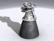
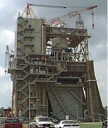
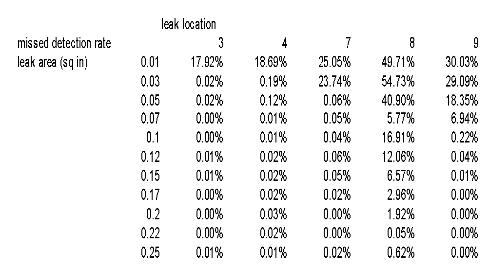
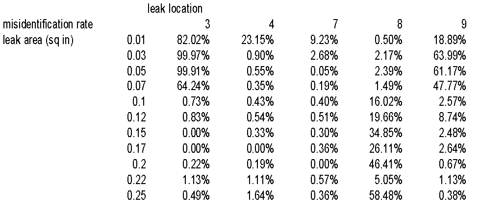
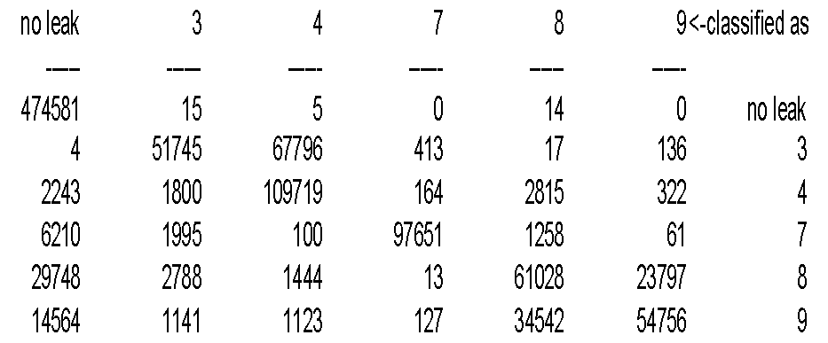
Using Decision Trees to Detect and Isolate Leaks in the J-2X recent views
National Aeronautics and Space Administration —
Full title: Using Decision Trees to Detect and Isolate Simulated Leaks in the J-2X Rocket Engine Mark Schwabacher, NASA Ames Research Center Robert Aguilar, Pratt... -
Federal
SDG Indicator 7.1.1: Access to Electricity, 2023 Release recent views
National Aeronautics and Space Administration —
The SDG Indicator 7.1.1: Access to Electricity, 2023 Release data set, part of the Sustainable Development Goal Indicators (SDGI) collection, measures the proportion... -
Federal
Global Human Modification of Terrestrial Systems recent views
National Aeronautics and Space Administration —
The Global Human Modification of Terrestrial Systems data set provides a cumulative measure of the human modification of terrestrial lands across the globe at a 1-km... -
Federal
U.S. Census Grids (Summary File 1), 1990: Metropolitan Statistical Areas recent views
National Aeronautics and Space Administration —
The U.S. Census Grids (Summary File 1), 1990: Metropolitan Statistical Areas data set contains grids of demographic and socioeconomic data from the year 1990 U.S....

Official websites use .gov
A
.gov website belongs to an official government
organization in the United States.
Secure .gov websites use HTTPS
A
lock (
) or https:// means you’ve safely connected to
the .gov website. Share sensitive information only on official,
secure websites.