
-
Federal
CERES and GEO-Enhanced TOA, Within-Atmosphere and Surface Fluxes, Clouds and Aerosols 1-Hourly Terra-Aqua-NOAA20 Edition4B
National Aeronautics and Space Administration —
CER_SYN1deg-1Hour_Terra-Aqua-NOAA20_Edition4B is the Clouds and the Earth's Radiant Energy System (CERES) and geostationary (GEO) Top-of-Atmosphere (TOA) Within-... -
Federal
ABoVE: Boreal Forest Resilience Study 2020-2022, Fairbanks AK
National Aeronautics and Space Administration —
This dataset includes five metrics of forest resilience (recruitment, invasives, permafrost change, tree damage, and radial growth) at five recently burned forest... -
Federal
ABoVE: Vegetation Composition across Fire History Gradients on the Y-K Delta, Alaska
National Aeronautics and Space Administration —
This dataset provides ecological field data that were collected during July 2017 and July 2018 from 43 plots spanning gradients of fire history in the upland tundra... -
Federal
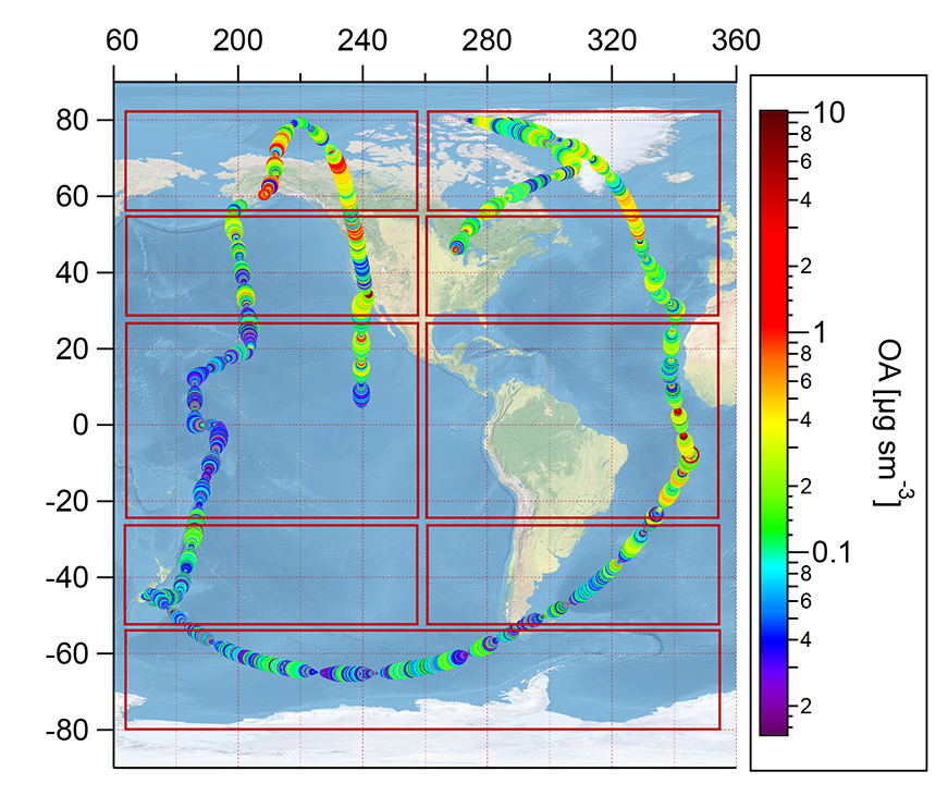
ATom: Observed and Modeled Organic Aerosol Mass Concentrations, 2016-2017
National Aeronautics and Space Administration —
This dataset provides airborne in situ observations of submicron organic aerosol (OA) mass concentrations during the first (mid-2016) and second (early-2017) global... -
Federal
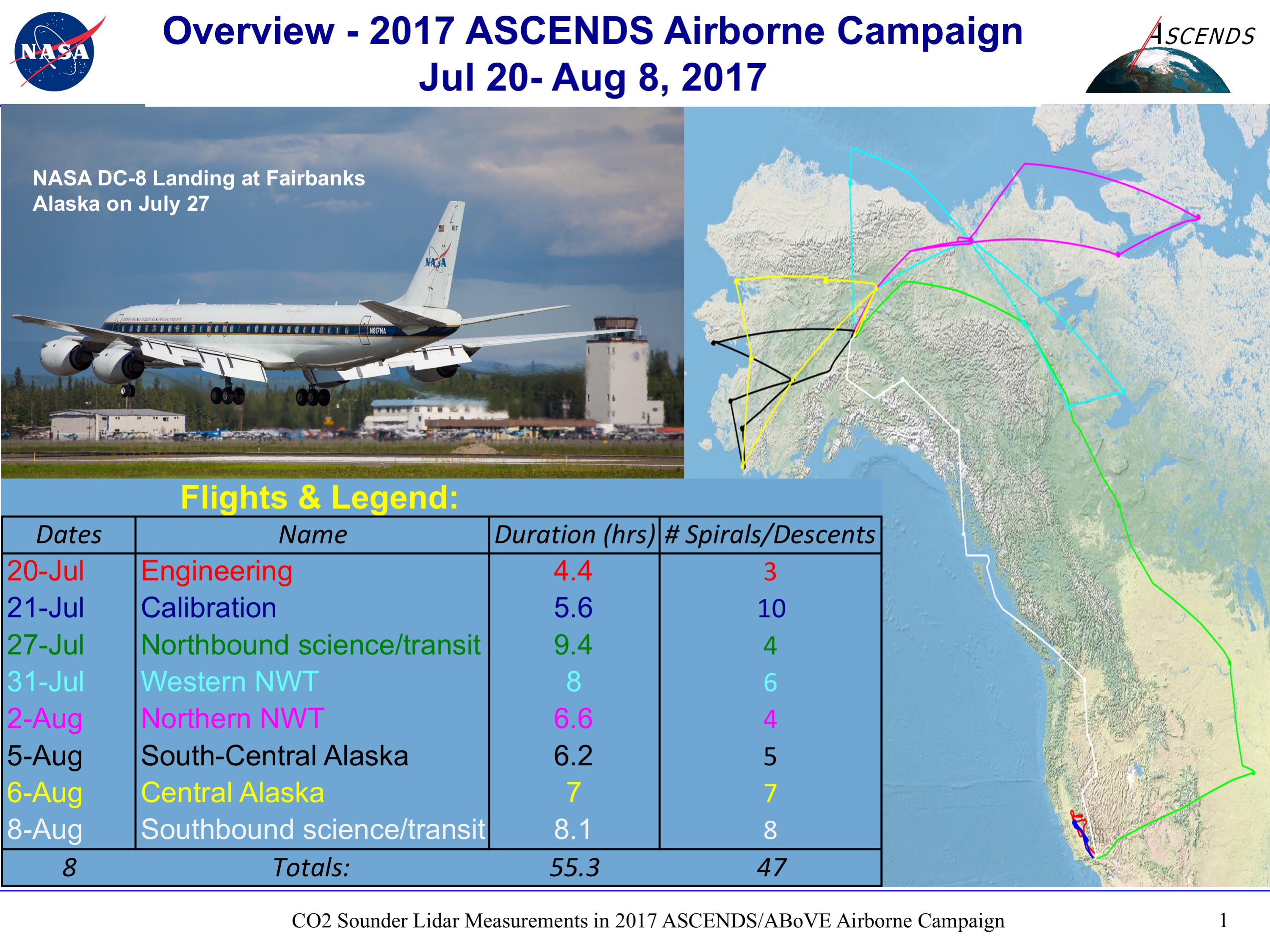
ABoVE/ASCENDS: Active Sensing of CO2, CH4, and Water Vapor, Alaska and Canada, 2017
National Aeronautics and Space Administration —
This dataset provides in situ airborne measurements of atmospheric carbon dioxide (CO2), methane (CH4), and water vapor concentrations, plus air temperature,... -
Federal
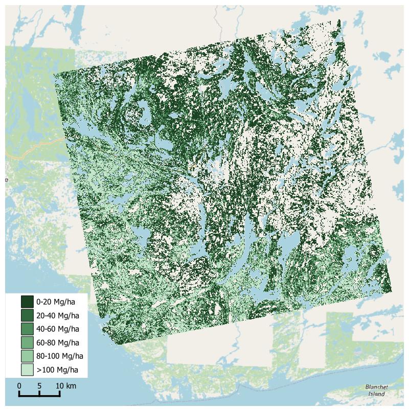
Aboveground Biomass from SAR, Great Slave Lake Region, NWT, 2019
National Aeronautics and Space Administration —
This dataset holds aboveground biomass (ABG) estimates for areas in the Great Slave Lake Region in the Northwest Territories of Canada for 2019. ABG was estimated... -
Federal
ABoVE: CO2 and CH4 Fluxes and Meteorology at Flux Tower Sites, Alaska, 2015-2017
National Aeronautics and Space Administration —
This dataset provides CO2 and CH4 fluxes and meteorological parameters from five eddy covariance (EC) tower sites located at Barrow (three sites), Atqasuk (ATQ) and... -
Federal
CATS-ISS Level 2 Operational Night Mode 7.2 Version 3-01 5 km Layer
National Aeronautics and Space Administration —
CATS-ISS_L2O_N-M7.2-V3-01_05kmLay is the Cloud-Aerosol Transport System (CATS) International Space Station (ISS) Level 2 Operational Night Mode 7.2 Version 3-01 5 km... -
Federal
CER_BDS_Terra-FM2_Edition4
National Aeronautics and Space Administration —
CER_BDS_Terra-FM2_Edition4 is the Clouds and the Earth's Radiant Energy System (CERES) Bidirectional Scans (BDS) Terra Flight Model 2 (FM2) Edition 4 data product,... -
Federal
ABoVE: Active Layer and Soil Moisture Properties from AirMOSS P-band SAR in Alaska
National Aeronautics and Space Administration —
This dataset provides estimates of soil geophysical properties derived from Airborne Microwave Observatory of Subcanopy and Subsurface (AirMOSS) P-band polarimetric... -
Federal
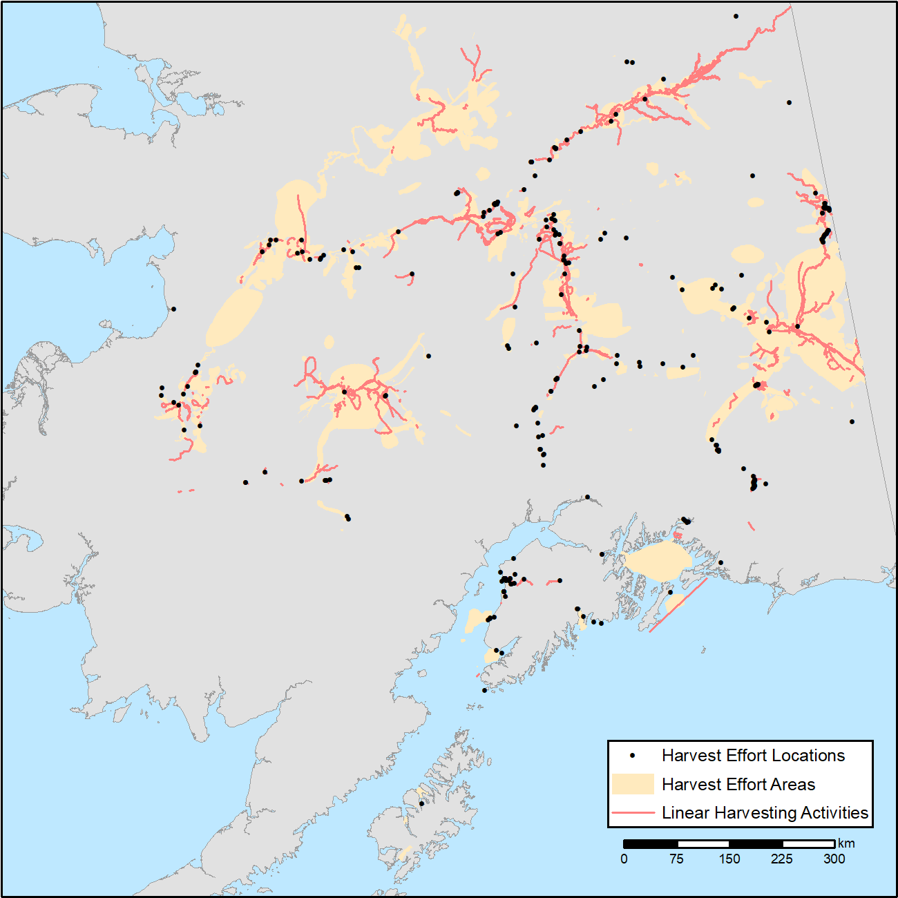
ABoVE: Subsistence Resource Use Areas of Interior Alaskan Communities, 2011-2017
National Aeronautics and Space Administration —
This dataset provide maps to show the search and harvest areas used by community residents for all subsistence resources combined across Interior Alaska for the years... -
Federal
ACT-America: L2 Remotely Sensed Column-average CO2 by Airborne Lidar, Eastern USA
National Aeronautics and Space Administration —
This dataset provides Level 2 (L2) remotely sensed column-average carbon dioxide (CO2) concentrations measured during airborne campaigns in Summer 2016, Winter 2017,... -
Federal
ABoVE: Distribution Maps of Wildland Fire Fuel Components across Alaskan Tundra, 2015
National Aeronautics and Space Administration —
This dataset provides maps of the distribution of three major wildland fire fuel types at 30 m spatial resolution covering the Alaskan arctic tundra, circa 2015. The... -
Federal
ABoVE: Needle-Level Chlorophyll Fluorescence, Alaska and Idaho, USA, 2017 and 2019
National Aeronautics and Space Administration —
This dataset provides the results of in situ measurements of needle-level chlorophyll fluorescence (ChlF) obtained from a pulse amplitude modulated (PAM) fluorometer... -
Federal
ATom: L2 In Situ Peroxyacetyl Nitrate (PAN) Measurements from Georgia Tech CIMS
National Aeronautics and Space Administration —
This dataset provides measurements of two important components of photochemical smog - peroxyacetyl nitrate (PAN) and peroxyl propionyl nitrate (PPN)- measured by the... -
Federal
CERES and GEO-Enhanced TOA, Within-Atmosphere and Surface Fluxes, Clouds and Aerosols Monthly-Averaged 1-Hourly Terra-Aqua Edition4A
National Aeronautics and Space Administration —
CER_SYN1deg-MHour_Terra-Aqua-MODIS_Edition4A is the Clouds and the Earth's Radiant Energy System (CERES) and geostationary (GEO)-Enhanced Top-of-Atmosphere (TOA),...

Official websites use .gov
A
.gov website belongs to an official government
organization in the United States.
Secure .gov websites use HTTPS
A
lock (
) or https:// means you’ve safely connected to
the .gov website. Share sensitive information only on official,
secure websites.