
-
Federal
ASTER Global DEM NGDA
National Aeronautics and Space Administration —
ASTER is capable of collecting in-track stereo using nadir- and aft-looking near infrared cameras. Since 2001, these stereo pairs have been used to produce single-... -
Federal
Exoplanet Orbit Database
National Aeronautics and Space Administration —
The Exoplanet Orbit Database is a database of well-determined orbital parameters of exoplanets, and their host stars' properties. This database comprises... -
Federal
MLS/Aura Near-Real-Time L2 Water Vapor (H2O) Mixing Ratio V005 (ML2H2O_NRT) at GES DISC
National Aeronautics and Space Administration —
ML2H2O_NRT is the EOS Aura Microwave Limb Sounder (MLS) Near-Real-Time (NRT) product for water vapor (H2O). This product contains H2O profiles derived from the 190... -
Federal
Thermal-Inertial UAV Night Dataset
National Aeronautics and Space Administration —
Thermal-Inertial UAV Night Dataset -
Federal
Real System Failures
National Aeronautics and Space Administration —
This resource area contains descriptions of actual electronic systems failure scenarios with an emphasis on the diversity of failure modes and effects that can befall... -
Federal
AKARI/FIS All-Sky Survey Bright Source Catalog, Version 1
National Aeronautics and Space Administration —
The AKARI Infrared Astronomical Satellite observed the whole sky in the far-infrared (50-180 microns or um) and the mid-infrared (9 and 18 um) between May 2006 and... -
Federal
Suomi-NPP VIIRS Regional Ocean Color (OC) - Near Real Time (NRT) Data, version R2022.0
National Aeronautics and Space Administration —
The Ocean Biology DAAC produces near real-time (quicklook) products using the best-available combination of ancillary data from meteorological and ozone data. As... -
Federal
EMIT L2B Estimated Mineral Identification and Band Depth and Uncertainty 60 m V001
National Aeronautics and Space Administration —
The Earth Surface Mineral Dust Source Investigation (EMIT) instrument measures surface mineralogy, targeting the Earth’s arid dust source regions. EMIT is installed... -
Federal
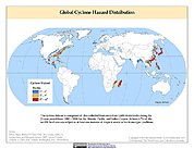
Global Cyclone Hazard Frequency and Distribution
National Aeronautics and Space Administration —
The Global Cyclone Hazard Frequency and Distribution is a 2.5 minute grid based on more than 1,600 storm tracks for the period 1 January 1980 through 31 December 2000... -
Federal
GPM GROUND VALIDATION ENVIRONMENT CANADA (EC) MANUAL PRECIPITATION MEASUREMENTS GCPEX V1
National Aeronautics and Space Administration —
The GPM Ground Validation Environment Canada (EC) Manual Precipitation Measurements GCPEx dataset was collected during the GPM Cold-season Precipitation Experiment... -
Federal
Reflectance Reference Targets (OTTER)
National Aeronautics and Space Administration —
Spectral reflectance measurements of flat field targets as reference points representative of psuedo-invariant targets as measured by the Spectron SE590... -
Federal
Western North American FLEXPART Back Trajectory 1999 Data
National Aeronautics and Space Administration —
WNA-FLEXPART-BackTraj-1999 is the 1999 Western North America Back Trajectory data using the FLEXible PARTicle (FLEXPART) dispersion model. Data collection for this... -
Federal
NASA Web-Enabled Landsat Data CONUS 30m Composites over Annual Periods V001
National Aeronautics and Space Administration —
WELDUSYR.015 was decommissioned on December 2, 2019. Users are encouraged to use the improved yearly Global Web-Enabled Landsat Data (GWELD) Version 3, 3.1, and 3.2... -
Federal
ECOSTRESS Swath Geolocation Instantaneous L1B Global 70 m V002
National Aeronautics and Space Administration —
The ECOsystem Spaceborne Thermal Radiometer Experiment on Space Station (ECOSTRESS) mission measures the temperature of plants to better understand how much water... -
Federal
BOREAS TE-18 Landsat TM Physical Classification Image of the SSA
National Aeronautics and Space Administration —
The objective of this classification is to provide the BOREAS investigators with a data product that characterizes the land cover of the SSA. A Landsat-5 TM image... -
Federal
BARREL 4F X-ray Spectrometer (USPC) Bremsstrahlung X-ray Spectrum Ultra Fast Time Resolution, Level 2, 10 ms Data
National Aeronautics and Space Administration —
USPC: 30 channels of ultra fast time resolution, 10 ms, Bremsstrahlung X-ray spectra. The channel count data are in raw format. The energy levels for bins in each... -
Federal
XMM-Newton Serendipitous Source Catalog (4XMM-DR14 Version)
National Aeronautics and Space Administration —
The XMMSSC table contains the Fourth XMM-Newton Serendipitous Source Catalog, Fourteenth Data Release, or 4XMM-DR14. 4XMM-DR14 is the fourth-generation catalog of... -
Federal
MMS 3 Electric Particle Detector, Fly's Eye Energetic Particle Sensor (EPD, FEEPS) Ions, Level 2 (L2), Survey Mode, 2.42 s Data
National Aeronautics and Space Administration —
Fly's Eye Electron Proton Spectrometer (FEEPS) Survey Data. The Energetic Particle Detector (EPD) investigation aboard the four MMS spacecraft consists of two... -
Federal
MMS 2 Magnetic Ephemeris and Coordinates (MEC) and Support (Tsyganenko 2004 model, Dynamic conditions), Level 2 (L2), Burst Mode, 30 ms Data
National Aeronautics and Space Administration —
Magnetospheric Multiscale 2 (MMS 2) spacecraft position, velocity, attitude, angular momentum vector, and magnetic ephemeris and coordinates (MEC), Level-2 science... -
Federal
CDDIS_GNSS_products_erp
National Aeronautics and Space Administration —
Earth Rotation Parameters (ERPs) derived from analysis of Global Navigation Satellite System (GNSS) data. These products are the generated by analysis centers in...

Official websites use .gov
A
.gov website belongs to an official government
organization in the United States.
Secure .gov websites use HTTPS
A
lock (
) or https:// means you’ve safely connected to
the .gov website. Share sensitive information only on official,
secure websites.