
-
Federal
ECOSTRESS Gridded Downscaled Meteorology Instantaneous L3 Global 70 m V002
National Aeronautics and Space Administration —
The ECOsystem Spaceborne Thermal Radiometer Experiment on Space Station (ECOSTRESS) mission measures the temperature of plants to better understand how much water... -
Federal
MLS/Aura Level 3 Daily Binned Relative Humidity With Respect To Ice (RHI) on Assorted Grids V005 (ML3DBRHI) at GES DISC
National Aeronautics and Space Administration —
ML3DBRHI is the EOS Aura Microwave Limb Sounder (MLS) daily binned on various vertical grids product for relative humidity with respect to ice (RHI) derived from... -
Federal
AMAZE-08 Aerosol Characterization and Meteorological Data, Central Amazon Basin: 2008
National Aeronautics and Space Administration —
This data set provides measurements from the Amazonian Aerosol Characterization Experiment (AMAZE-08) carried out during the wet season from February 4 to March 21,... -
Federal
TOLNet NASA Goddard Space Flight Center Data
National Aeronautics and Space Administration —
TOLNet_GSFC_Data is the lidar data collected by the Tropospheric Ozone (TROPOZ) lidar at the Goddard Space Flight Center (GSFC) as part of the Tropospheric Ozone... -
Federal
Puerto Rico Radiosondes CPEX-AW V1
National Aeronautics and Space Administration —
The Puerto Rico Radiosondes CPEX-AW dataset consists of atmospheric pressure, atmospheric temperature, relative humidity, wind speed, and wind direction measurements.... -
Federal
SAFARI 2000 Surface Atmospheric Radiative Transfer (SMART), Dry Season 2000
National Aeronautics and Space Administration —
Surface-sensing Measurements for Radiative Transfer (SMART) and Chemical, Optical, and Microphysical Measurements of In-situ Troposphere (COMMIT) consist of a suite... -
Federal
In-situ Air Temperature and Relative Humidity in Greenbelt, MD, 2013-2015
National Aeronautics and Space Administration —
This data set describes the temperature and relative humidity at 12 locations around Goddard Space Flight Center in Greenbelt MD at 15 minute intervals between... -
Federal
First ISCCP Regional Experiment (FIRE) Atlantic Stratocumulus Transition Experiment (ASTEX) Oceanus Radiosonde Data
National Aeronautics and Space Administration —
The First ISCCP Regional Experiments (FIRE) have been designed to improve data products and cloud/radiation parameterizations used in general circulation models... -
Federal
Daily SnowModel Outputs Covering the ABoVE Core Domain, 3-km Resolution, 1980-2020
National Aeronautics and Space Administration —
This dataset provides daily SnowModel simulation outputs on a 3-km grid for the period 1 September 1980 through 31 August 2020, covering the Core ABoVE Domain. The... -
Federal
ACCLIP WB-57 Aircraft Merge Data
National Aeronautics and Space Administration —
ACCLIP_Merge_WB57-Aircraft_Data is the pre-generated merge files created from a variety of in-situ instrumentation collecting measurements onboard the WB-57 aircraft... -
Federal
ACCLIP WB-57 Aircraft Model Data
National Aeronautics and Space Administration —
ACCLIP_Model_WB57_Data contains modeled meteorological, chemical, and aerosol data along the flight tracks of the WB-57 aircraft during the Asian Summer Monsoon... -
Federal
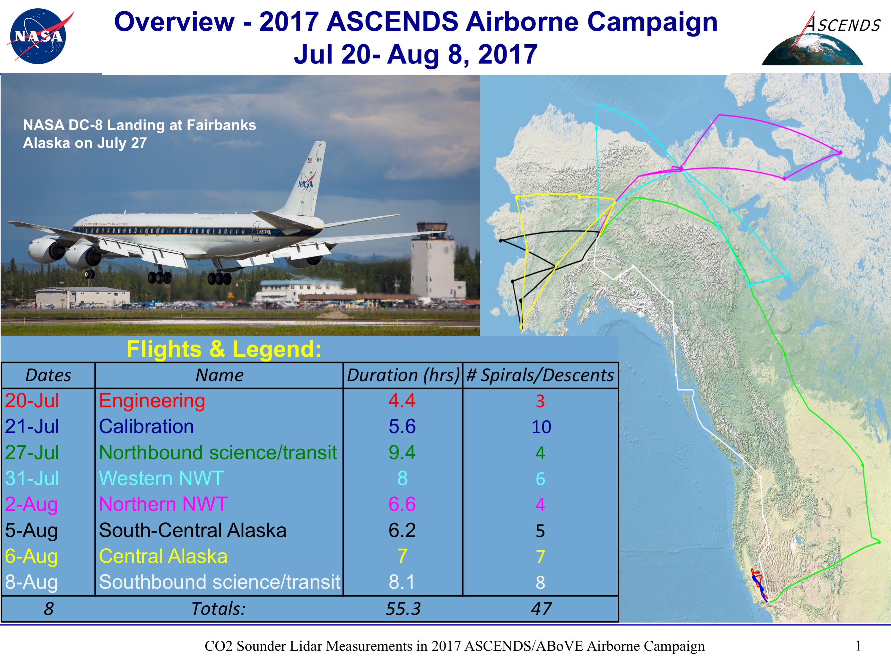
ABoVE/ASCENDS: Active Sensing of CO2, CH4, and Water Vapor, Alaska and Canada, 2017
National Aeronautics and Space Administration —
This dataset provides in situ airborne measurements of atmospheric carbon dioxide (CO2), methane (CH4), and water vapor concentrations, plus air temperature,... -
Federal
GPM GROUND VALIDATION ENVIRONMENT CANADA (EC) RADIOMETER GCPEX V1
National Aeronautics and Space Administration —
The GPM Ground Validation Environment Canada (EC) Radiometer GCPEx dataset contains retrievals of temperature, water vapor, relative humidity, liquid water profiles... -
Federal
Sounder SIPS: AQUA AIRS IR-only Level 2: Atmospheric state at Standard Pressure Levels derived from CLIMCAPS V2.1 (SNDRAQIL2PLEVCPS) at GES DISC
National Aeronautics and Space Administration —
The CLIMCAPS (Community Long-term Infrared Microwave Coupled Product System) algorithm is used to analyze data from the AIRS (Atmospheric Infrared Sounder) instrument... -
Federal
Sounder SIPS: Suomi NPP ATMS Level 2 RAMSES2 Standard: Atmosphere, precipitation and surface geophysical state, V3 (SNDRSNML2RMS ) at GES DISC
National Aeronautics and Space Administration —
This level 2 product is generated by the RAMSES (Retrieval Algorithm for Microwave Sounders in Earth Science) II algorithm.The RAMSES II algorithm is a microwave only... -
Federal
SARP-East 2023 Data
National Aeronautics and Space Administration —
SARP_2023_East_Data is the ground site data and data collected onboard the Dynamic Aviation B200 aircraft during the 2023 deployment of the Student Airborne Research... -
Federal
SARP 2024 Data
National Aeronautics and Space Administration —
SARP_2024_Data is the data collected onboard the NASA P-3B and the Dynamic Aviation B200 aircrafts during the 2024 deployment of the Student Airborne Research Program... -
Federal
OWLETS-2 Surface (Ground) Data
National Aeronautics and Space Administration —
OWLETS2_Surface_Data_1 is the Ozone Water-Land Environmental Transition Study (OWLETS-2) data collected via in-situ and remote sensing instrumentation at various... -
Federal
NARSTO EPA Supersite (SS) Fresno, Beta Attenuation Monitors (BAM) Meteorological Data
National Aeronautics and Space Administration —
NARSTO_EPA_SS_FRESNO_MET_DATA is North American Research Strategy for Tropospheric Ozone (NARSTO) Environmental Protection Agency (EPA) Supersite (SS) Fresno, Beta... -
Federal
Supporting Information for Doppler Orbitography and Radiopositioning Integrated by Satellite (DORIS) Data and Products from NASA CDDIS
National Aeronautics and Space Administration —
Doppler Orbitography and Radiopositioning Integrated by Satellite (DORIS) Data (multi-day files) from the NASA Crustal Dynamics Data Information System (CDDIS). DORIS...

Official websites use .gov
A
.gov website belongs to an official government
organization in the United States.
Secure .gov websites use HTTPS
A
lock (
) or https:// means you’ve safely connected to
the .gov website. Share sensitive information only on official,
secure websites.