

11 datasets found for ""Aerial Photos""
-
Federal
North American Landscape Characterization
National Aeronautics and Space Administration —
The North American Landscape Characterization (NALC) project is a component of the Landsat Pathfinder Program, which is part of a larger Pathfinder Program initiated... -
Federal
Aerial Photo Single Frames
National Aeronautics and Space Administration —
The Aerial Photography Single Frame Records collection is a large and diverse group of imagery acquired by Federal organizations from 1937 to the present. Over 6.4... -
Federal
Borehole and environmental protection descriptive and numerical data, Yamal Peninsula, Russia, Version 1
National Aeronautics and Space Administration —
This database of selected borehole records from the Yamal Peninsula, Russia, contains environmental descriptions (textual and numerical) of the units on the index... -
Federal
Spaceborne Imaging Radar-C Precision
National Aeronautics and Space Administration —
Spaceborne Imaging Radar-C/X-band Synthetic Aperture Radar (SIR-C/X-SAR) is a joint project of the National Aeronautics and Space Administration (NASA), the German... -
Federal
SAFARI 2000 ER-2 Color-IR Aerial Photography, Dry Season 2000
National Aeronautics and Space Administration —
Aerial photography from the NASA ER-2 high altitude aircraft was collected to provide detailed and spatially extensive documentation over parts of the SAFARI study... -
Federal
AVHRR 1-km Orbital Segments
National Aeronautics and Space Administration —
The Advanced Very High Resolution Radiometer (AVHRR) 1-km Orbital Segments data set is a component of the National Aeronautics and Space Administration (NASA) AVHRR... -
Federal
NASA Landsat Data Collection
National Aeronautics and Space Administration —
The NASA Landsat Data Collection (NLDC) is a compilation of Landsat multispectral scanner (MSS) scenes and Landsat thematic mapper (TM) scenes. This compilation of... -
Federal
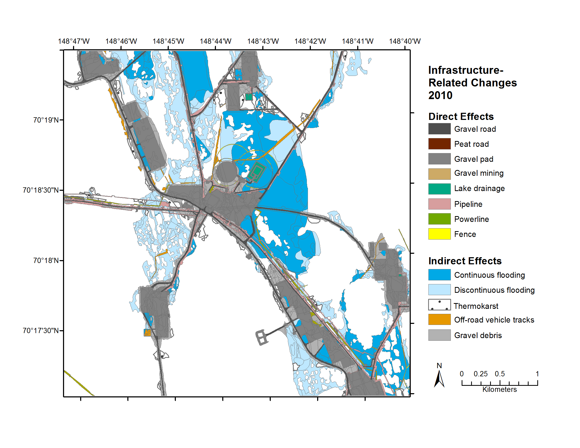
Geobotanical and Impact Map Collection for Prudhoe Bay Oilfield, Alaska, 1972-2010
National Aeronautics and Space Administration —
This data set provides a collection of maps of geoecological characteristics of areas within the Beechey Point quadrangle near Prudhoe Bay on the North slope of... -
Federal
LBA-ECO LC-09 Land Cover Transitions Maps for Study Sites in Para, Brazil: 1970-2001
National Aeronautics and Space Administration —
This data set includes classified land cover transition maps at 30-m resolution derived from Landsat TM, MSS, ETM+ imagery and aerial photos of Altamira, Santarem,... -
Federal
Glacier Inventory of West Greenland, 1948 - 1985, Version 1
National Aeronautics and Space Administration —
The inventory includes 5,297 Glaciers from west Greenland between 59 to 71 degrees latitude north and 43 to 53 degrees longitude west. The glacier data basin division... -
Federal
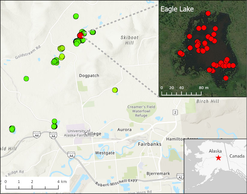
ABoVE: Methane Ebullition Hotspots in Frozen Lakes near Fairbanks, Alaska, Oct 2014
National Aeronautics and Space Administration —
This dataset includes maps of the locations and number of methane ebullition hotspots in 15 frozen lakes in the southern portion of the Goldstream Valley and the...
11 datasets found for ""Aerial Photos""