
-
Federal
Land Use and Cover Maps from Landsat, Mawas, Central Kalimantan, Indonesia, 1994-2019
National Aeronautics and Space Administration —
This dataset contains annual land use/cover (LUC) maps at 30 m resolution across Mawas, Central Kalimantan, Indonesia. There are six files, each representing a five-... -
Federal
Arctic Vegetation Plots for IBP Tundra Biome, Barrow, Alaska, 1972-2010
National Aeronautics and Space Administration —
This data set provides vegetation cover and environmental plot data collected as part of the International Biological Program (IBP), U. S. Tundra Biome Program, in... -
Federal
BioSCape Vegetation Surveys Berg and Eerste River Catchments, South Africa, 2022-2023
National Aeronautics and Space Administration —
This dataset contains vegetation plot survey data collected at 36 sites across the Berg and Eerste River catchments in the Western Cape, South Africa collected during... -
Federal
ABoVE: Wetland Vegetation Classification for Peace-Athabasca Delta, Canada, 2019
National Aeronautics and Space Administration —
This dataset contains land cover classification focused on water and wetland vegetation communities over the Peace-Athabasca Delta, Canada. Four classification maps... -
Federal
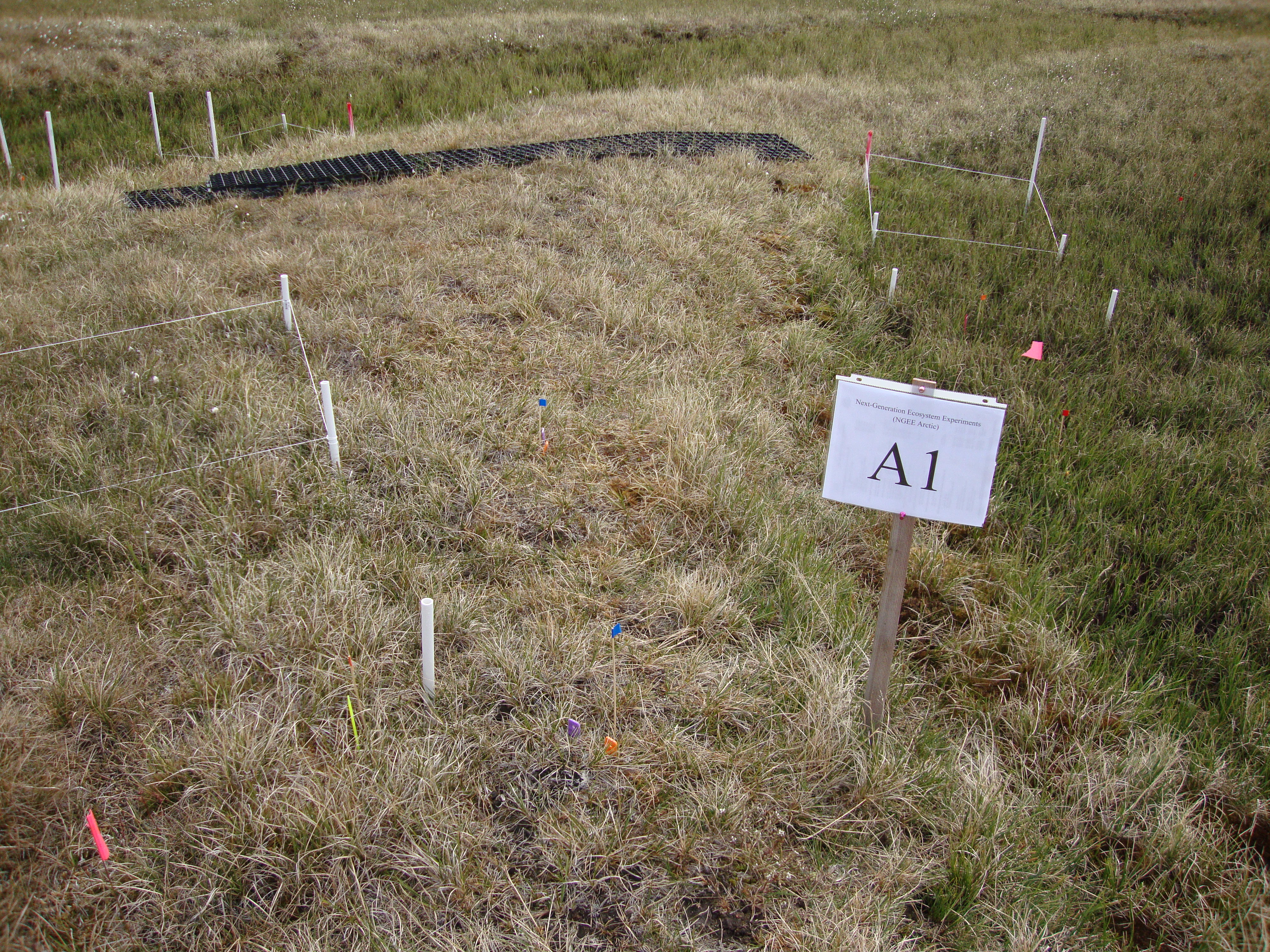
Arctic Vegetation Plots for NGEE-Arctic at Barrow, Alaska, 2012
National Aeronautics and Space Administration —
This data set provides vegetation cover and environmental plot data collected on the Barrow Environmental Observatory (BEO), Barrow, Alaska in 2012. Forty-eight 1 x 1... -
Federal
Aboveground Biomass Density for High Latitude Forests from ICESat-2, 2020
National Aeronautics and Space Administration —
This dataset provides estimates of Aboveground dry woody Biomass Density (AGBD) for high northern latitude forests at a 30-m spatial resolution. It is designed both... -
Federal
BOREAS SERM Forest Cover Data Layers of the SSA in Vector Format
National Aeronautics and Space Administration —
The forest cover data provided by Saskatchewan Environment and Resource Management, Forestry Branch - Inventory Unit (SERM-FBIU) are basically a digital version of... -
Federal
ABoVE: Lake Growing Season Green Surface Reflectance Trends, AK and Canada, 1984-2019
National Aeronautics and Space Administration —
This dataset provides an annual time series of Landsat green surface reflectance and the derived annual trend during the growing season (June and July) for 472,890... -
Federal
NACP Peatland Land Cover Map of Upper Peninsula, Michigan, 2007-2011
National Aeronautics and Space Administration —
This dataset provides a land cover map focused on peatland ecosystems in the upper peninsula of Michigan. The map was produced at 12.5-m resolution using a multi-... -
Federal
BOREAS CanSIS Regional Soils Data in Vector Format, V2
National Aeronautics and Space Administration —
This data set contains soils data from the Canada Soil Information System (CanSIS) in ESRI Shapefile format for the provinces of Saskatchewan and Manitoba. They are... -
Federal
LBA-ECO CD-17 Secondary Forest Survey, Para and Rondonia, Brazil: 2002-2003
National Aeronautics and Space Administration —
This data set provides measurements for diameter at breast height (DBH), tree height, distance from tree stems to the furthest canopy element, and a species survey of... -
Federal
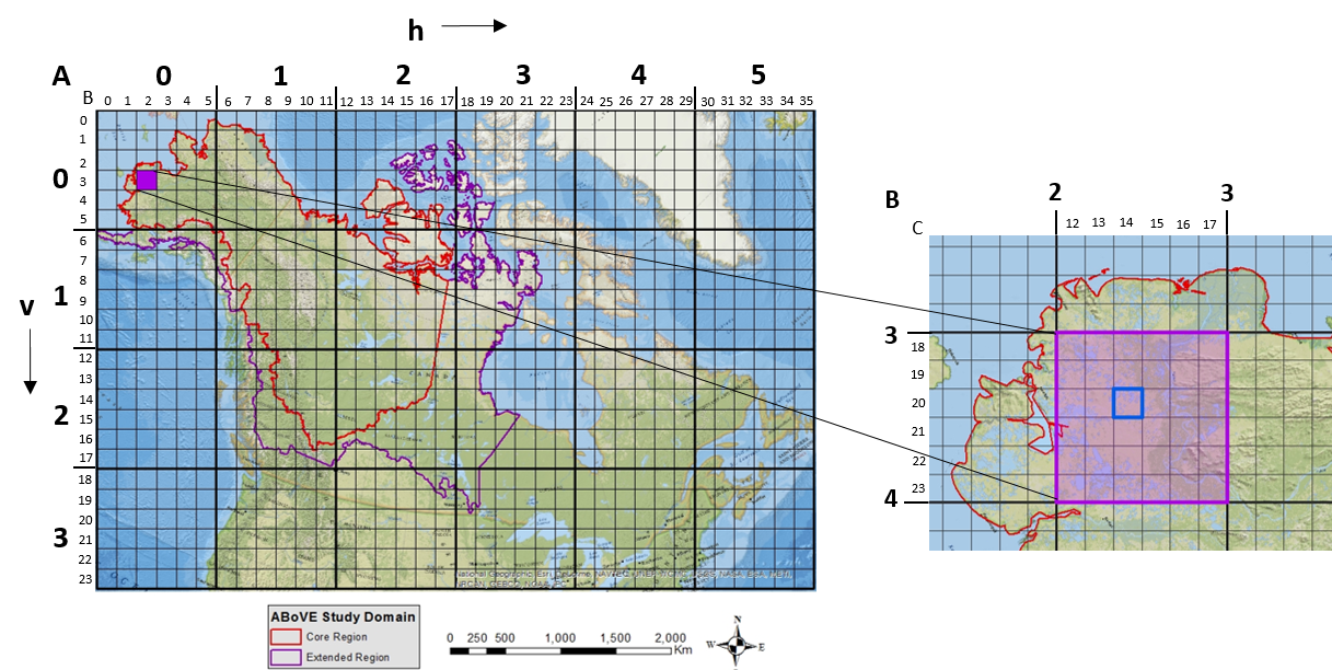
ABoVE: Study Domain and Standard Reference Grids
National Aeronautics and Space Administration —
The Arctic - Boreal Vulnerability Experiment (ABoVE) has developed two standardized spatial data products to expedite coordination of research activities and to... -
Federal
Impacts of Wildfires on Boreal Forest Ecosystem Carbon Dynamics
National Aeronautics and Space Administration —
This dataset contains simulations of net primary production (NPP), heterotrophic respiration (RH), net ecosystem production (NEP), and soil temperature data in North... -
Federal
AVIRIS Facility Instruments: Flight Line Geospatial and Contextual Data
National Aeronautics and Space Administration —
This dataset provides attributed geospatial and tabular information for identifying and querying flight lines of interest for the Airborne Visible InfraRed Imaging... -
Federal
Soil Carbon Estimates in 20-cm Layers to 1-meter Depth, Conterminous US, 1970-1993
National Aeronautics and Space Administration —
This data set provides a soil map with estimates of soil carbon (C) in g C/m2 for 20-cm layers from the surface to one meter depth for the conterminous United... -
Federal
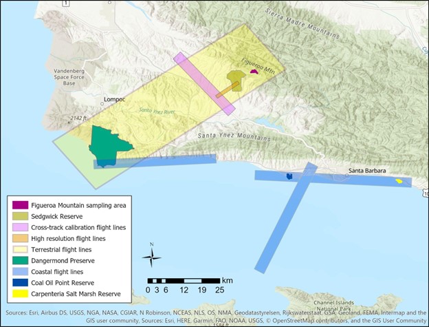
SHIFT: Vegetation Plot Characterization, Santa Barbara County, CA, 2022
National Aeronautics and Space Administration —
This dataset contains vegetation plot locations, descriptions, fractional cover, and sample identifier information from surveys conducted as part of the 2022 NASA... -
Federal
ABoVE: Study Domain and Standard Reference Grids, Version 2
National Aeronautics and Space Administration —
The Arctic - Boreal Vulnerability Experiment (ABoVE) has developed two standardized spatial data products to expedite coordination of research activities and to... -
Federal
BOREAS Follow-On DSP-10 Regridded Peatland Maps
National Aeronautics and Space Administration —
These images were produced by aggregating 1' gridded data layers derived from the polygon-based Peatlands of Canada Database (Tarnocai et al., 2000) to 10'... -
Federal
ABoVE: Lake and Pond Extents in Alaskan Boreal and Tundra Subregions, 2019-2021
National Aeronautics and Space Administration —
This dataset provides polygon spatial files of lake and pond extents for three sub-regions of Interior Alaska's boreal forest, and one tundra region located in... -
Federal
LBA-ECO LC-07 Monthly Inundated Areas, Amazon, Orinoco and Pantanal Basins: 1978-1987
National Aeronautics and Space Administration —
This data set reports the monthly record of inundated area, in square km, for six floodplain and open water regions in South America. The following floodplains were...

Official websites use .gov
A
.gov website belongs to an official government
organization in the United States.
Secure .gov websites use HTTPS
A
lock (
) or https:// means you’ve safely connected to
the .gov website. Share sensitive information only on official,
secure websites.