
-
Federal
Global MODIS and FLUXNET-derived Daily Gross Primary Production, V2
National Aeronautics and Space Administration —
This dataset provides global gridded daily estimates of gross primary production (GPP) and uncertainties at 0.05-degree resolution for the period 2000-03-01 to the... -
Federal
ATom: Merged Atmospheric Chemistry, Trace Gases, and Aerosols, Version 2
National Aeronautics and Space Administration —
This dataset provides information on greenhouse gases and human-produced air pollution, including atmospheric concentrations of carbon dioxide (CO2), methane (CH4),... -
Federal
BOREAS TE-20 Site Characteristics Data
National Aeronautics and Space Administration —
The BOREAS TE-20 team collected several data sets for use in developing and testing models of forest ecosystem dynamics. This data set contains measurements of site... -
Federal
BOREAS RSS-08 Snow Maps Derived from Landsat TM Imagery
National Aeronautics and Space Administration —
The BOREAS RSS-08 team utilized Landsat TM images to perform mapping of snow extent over the SSA. This data set consists of two Landsat TM images which were used to... -
Federal
LBA-ECO ND-03 Stream and Soil Water Data, Fazenda Nova Vida, Rondonia: 1994-2001
National Aeronautics and Space Administration —
This data set provides the results of (1) the physical and chemical characterization of streams and (2) comparable chemical analyses of extracted soil water in the... -
Federal
LBA-ECO LC-04 Satellite/Census-Based 5-Minute Land Use Data, Amazonia: 1980 and 1995
National Aeronautics and Space Administration —
Amazonia has been under considerable development pressure as croplands and pasture are established in areas formerly occupied by tropical forest and cerrado. Although... -
Federal
Global Distribution of Plant-Extractable Water Capacity of Soil (Dunne)
National Aeronautics and Space Administration —
Plant-extractable water capacity of soil is the amount of water that can be extracted from the soil to fulfill evapotranspiration demands. It is often assumed to be... -
Federal
ISLSCP II Globalview: Atmospheric CO2 Concentrations
National Aeronautics and Space Administration —
The GlobalView Carbon Dioxide (CO2) data product contains synchronized and smoothed time series of atmospheric CO2 concentrations at selected sites that were created... -
Federal
LBA-ECO ND-11 Pre-harvest Forest Tree and Liana Biomass, NW Mato Grosso, Brazil: 2003
National Aeronautics and Space Administration —
The purpose of this study was to determine if spatially-explicit commercial timber inventories (CTI) could be used in conjunction with satellite imagery to improve... -
Federal
Global Data Set of Derived Soil Properties, 0.5-Degree Grid (ISRIC-WISE)
National Aeronautics and Space Administration —
The World Inventory of Soil Emission Potentials (WISE) database currently contains data for over 4300 soil profiles collected mostly between 1950 and 1995. This... -
Federal
LBA-ECO LC-01 Landsat MSS, TM, ETM+ Imagery, Northern Ecuadorian Amazon: 1973-2002
National Aeronautics and Space Administration —
This data set contains a time series of early Landsat-4 MSS satellite imagery as well as Landsat-5 TM and Landsat-7 ETM+ satellite imagery of the northern Ecuadorian... -
Federal
BioSCape Vegetation Surveys Berg and Eerste River Catchments, South Africa, 2022-2023
National Aeronautics and Space Administration —
This dataset contains vegetation plot survey data collected at 36 sites across the Berg and Eerste River catchments in the Western Cape, South Africa collected during... -
Federal
SAFARI 2000 Wetlands Data Set, 1-Deg (Matthews and Fung)
National Aeronautics and Space Administration —
This database, compiled by Matthews and Fung (1987), provides information on the distribution and environmental characteristics of natural wetlands. The database was... -
Federal
LBA-ECO LC-04 IBIS Model Simulations for the Amazon and Tocantins Basins: 1921-1998
National Aeronautics and Space Administration —
The provided data were generated by the Integrated BIosphere Simulator (IBIS) terrestrial ecosystem model (Foley et al. 1996, Kucharik et al. 2000) using data from... -
Federal
LBA-ECO CD-10 Coarse Woody Debris Data at km 67 Tower Site, Tapajos National Forest
National Aeronautics and Space Administration —
This data sets reports properties of fallen course woody debris in an old-growth upland forest at the Para Western (Santarem) - km 67, Primary Forest Tower Site. This... -
Federal
BOREAS TE-20 Soils Data over the NSA-MSA and Tower Sites in Raster Format
National Aeronautics and Space Administration —
This data set was gridded from vector layers of soil maps that were received from Dr. Hugo Veldhuis, who did the original mapping in the field during 1994. The vector... -
Federal
LBA-ECO LC-07 CO2 and CH4 Flux from Wetlands, Negro River Basin, Brazil: 2004-2006
National Aeronautics and Space Administration —
This data set provides estimates of daily and monthly carbon dioxide (CO2) and methane (CH4) diffusive and ebullitive flux for dry and flooded areas from two study... -
Federal
LBA Regional Organic Soil Carbon and Nitrogen Data (Zinke et al.)
National Aeronautics and Space Administration —
The data set contains a subset of a global organic soil carbon and nitrogen data set (Zinke et al. 1986). The subset was created for the study area of the Large Scale... -
Federal
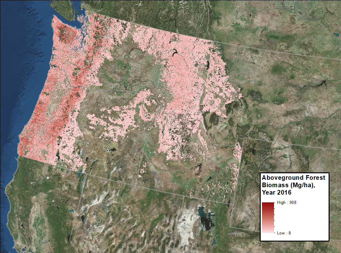
Annual Aboveground Biomass Maps for Forests in the Northwestern USA, 2000-2016
National Aeronautics and Space Administration —
This dataset provides annual maps of aboveground biomass (AGB, Mg/ha) for forests in Washington, Oregon, Idaho, and western Montana, USA, for the years 2000-2016, at... -
Federal
CARVE: L1 Airborne Forward Looking Infrared Radiance Counts, Alaska, 2013-2015
National Aeronautics and Space Administration —
This data set provides earth referenced radiance counts measured by the Forward Looking Infrared (FLIR) camera aboard the CARVE aircraft between April 2013 and...

Official websites use .gov
A
.gov website belongs to an official government
organization in the United States.
Secure .gov websites use HTTPS
A
lock (
) or https:// means you’ve safely connected to
the .gov website. Share sensitive information only on official,
secure websites.