
-
Federal
Geostationary Lightning Mapper (GLM) Thunder Hour Data Product
National Aeronautics and Space Administration —
The Geostationary Lightning Mapper (GLM) is the first optical lightning detector in geostationary orbit, and GLM sensors operate aboard the National Oceanic and... -
Federal
REGIONAL AIR-SEA INTERACTION (RASI) GAP WIND AND COASTAL UPWELLING EVENTS CLIMATOLOGY GULF OF PANAMA, PANAMA V1
National Aeronautics and Space Administration —
The Regional Air-Sea Interactions (RASI) Gap Wind and Coastal Upwelling Events Climatology Gulf of Panama, Panama dataset was created using an automated intelligent... -
Federal
Flight Reports EPOCH
National Aeronautics and Space Administration —
The Flight Reports EPOCH dataset consists of flight number, purpose of flight, and flight hours logged during the East Pacific Origins and Characteristics of... -
Federal
AMPR BRIGHTNESS TEMPERATURE CAMEX-1 V2
National Aeronautics and Space Administration —
The Advanced Microwave Precipitation Radiometer (AMPR) was deployed during the Convection and Moisture Experiments (CAMEX-1) conducted at Wallops Island, VA. AMPR... -
Federal
GRIP HURRICANE IMAGING RADIOMETER (HIRAD) V1
National Aeronautics and Space Administration —
The GRIP Hurricane Imaging Radiometer (HIRAD) V1 dataset contains measurements of brightness temperature taken at 4, 5, 6 and 6.6 GHz, as well as MERRA 2 m wind speed... -
Federal
GPM GROUND VALIDATION NOAA CPC MORPHING TECHNIQUE (CMORPH) IPHEX V1
National Aeronautics and Space Administration —
The GPM Ground Validation NOAA CPC Morphing Technique (CMORPH) IPHEx dataset consists of global precipitation analyses data produced by the NOAA Climate Prediction... -
Federal
GPM Ground Validation Precipitation Imaging Package (PIP) ICE POP V1
National Aeronautics and Space Administration —
The GPM Ground Validation Precipitation Imaging Package (PIP) ICE POP dataset includes precipitation measurements and video images collected by the Precipitation... -
Federal
Hurricane and Severe Storm Sentinel (HS3) Statistical Hurricane Intensity Prediction Scheme (SHIPS) Intensity V1
National Aeronautics and Space Administration —
The Hurricane and Severe Storm Sentinel (HS3) Statistical Hurricane Intensity Prediction Scheme (SHIPS) Intensity dataset was obtained from March 18, 2014 through... -
Federal
GPM Ground Validation Optical Disdrometer (ODM) LPVEx
National Aeronautics and Space Administration —
The GPM Ground Validation Optical Disdrometer (ODM) LPVEx dataset consists of precipitation particle size distribution data collected by the Eigenbrodt Optical... -
Federal
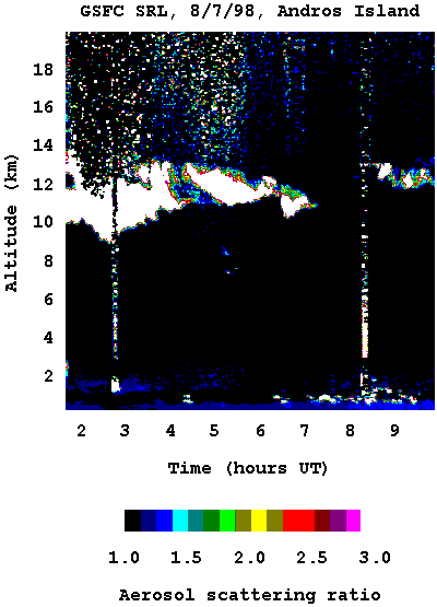
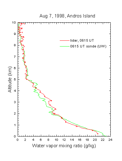
CAMEX-3 SCANNING RAMAN LIDAR V1
National Aeronautics and Space Administration —
The CAMEX-3 Scanning Raman LIDAR dataset collected data during the CAMEX-3 campaign on Andros Island during the period 6 August - 20 September 1998. The SRL... -
Federal
Puerto Rico Radiosondes CPEX-AW V1
National Aeronautics and Space Administration —
The Puerto Rico Radiosondes CPEX-AW dataset consists of atmospheric pressure, atmospheric temperature, relative humidity, wind speed, and wind direction measurements.... -
Federal
GPM GROUND VALIDATION ACHIEVE W-BAND CLOUD RADAR IPHEX V1
National Aeronautics and Space Administration —
The GPM Ground Validation ACHIEVE W-band Cloud Radar IPHEx dataset consists of cloud and light precipitation radar observations gathered during the Global... -
Federal
RSS SSM/I OCEAN PRODUCT GRIDS MONTHLY AVERAGE FROM DMSP F15 NETCDF V7
National Aeronautics and Space Administration —
The RSS SSM/I Ocean Product Grids Monthly Average from DMSP F15 netCDF dataset is part of the collection of Special Sensor Microwave/Imager (SSM/I) and Special Sensor... -
Federal
TCSP AMPR BRIGHTNESS TEMPERATURE (TB) V2
National Aeronautics and Space Administration —
The TCSP AMPR Brightness Temperature (TB) dataset consists of brightness temperature measurements from July 5, 2005 to July 27, 2005. The Advanced Microwave... -
Federal
GPM GROUND VALIDATION NASA MICRO RAIN RADAR (MRR) MC3E V1
National Aeronautics and Space Administration —
The GPM Ground Validation NASA Micro Rain Radar (MRR) MC3E dataset was collected by a Micro Rain Radar (MRR), which is a vertically pointing Doppler radar which... -
Federal
RSS SSM/I OCEAN PRODUCT GRIDS WEEKLY AVERAGE FROM DMSP F15 NETCDF V7
National Aeronautics and Space Administration —
The RSS SSM/I Ocean Product Grids Weekly Average from DMSP F15 netCDF dataset is part of the collection of Special Sensor Microwave/Imager (SSM/I) and Special Sensor... -
Federal
ADVANCED MICROWAVE SOUNDING UNIT-A (AMSU-A) SWATH FROM NOAA-15
National Aeronautics and Space Administration —
AMSU-A, the Advanced Microwave Sounding Unit, is a 15-channel passive microwave radiometer used to profile atmospheric temperature and moisture from the earth's... -
Federal
LIS/OTD 2.5 Degree Low Resolution Monthly Climatology Time Series (LRMTS) V2.3.2015
National Aeronautics and Space Administration —
The LIS/OTD 2.5 Degree Low Resolution Monthly Climatology Time Series (LRMTS) contains a variety of gridded climatologies of total lightning flash rates obtained from... -
Federal
GRIP Hurricane and Tropical Storm Forecasts V1
National Aeronautics and Space Administration —
The GRIP Hurricane and Tropical Storm Forecasts dataset consists of tropical cyclone model forecast tracks archived during the NASA Genesis and Rapid Intensification... -
Federal
GPM GROUND VALIDATION CLOUD SPECTROMETER AND IMPACTOR (CIP) LPVEX V1
National Aeronautics and Space Administration —
The GPM Ground Validation Cloud Spectrometer and Impactor (CIP) LPVEx dataset provides particle size spectra for the Global Precipitation Measurement (GPM) Misson...

Official websites use .gov
A
.gov website belongs to an official government
organization in the United States.
Secure .gov websites use HTTPS
A
lock (
) or https:// means you’ve safely connected to
the .gov website. Share sensitive information only on official,
secure websites.