
-
Federal
Measurements stretching across the Pacific Ocean to the Hawaiian Islands from 1998 to 1999
National Aeronautics and Space Administration —
Measurements made primarily in Micronesia, but stretching across the Pacific Ocean to the Hawaiian Islands from 1998 to 1999. -
Federal
MODIS/Terra Thermal Anomalies/Fire 5-Min L2 Swath 1km V006
National Aeronautics and Space Administration —
The MOD14 Version 6 data product was decommissioned on July 31, 2023. Users are encouraged to use the MOD14 Version 6.1 data product.The Moderate Resolution Imaging... -
Federal
ACE Electron Proton Alpha Monitor (EPAM) LEFS150 MFSA, Spacecraft Frame, Sectored Proton Fluxes, 17 min Averages
National Aeronautics and Space Administration —
17-min-averaged sectored proton fluxes from the MF Spectrum Analyzer of the ACE/EPAM LEFS150 instrument. All energies thresholds take into account the incident... -
Federal
KAKQ NEXRAD IMPACTS V1
National Aeronautics and Space Administration —
The KAKQ NEXRAD IMPACTS dataset consists of Next Generation Weather Radar (NEXRAD) Level II surveillance data that were collected from January 1 to March 1, 2020... -
Federal
Spitzer Wide-area InfraRed Extragalactic Survey Lockman Hole MIPS24 Single-Band Catalog
National Aeronautics and Space Administration —
The Spitzer Wide-area InfraRed Extragalactic survey (SWIRE), the largest Spitzer Legacy program, is a wide-area, imaging survey to trace the evolution of dusty, star-... -
Federal
GEWEX SRB Integrated Product (Rel-4) Shortwave Monthly Average by UTC Fluxes
National Aeronautics and Space Administration —
GEWEXSRB_Rel4-IP_Shortwave_monthly_utc is the Global Energy and Water Exchanges (GEWEX) Surface Radiation Budget (SRB) Integrated Product (Rel-4) Shortwave Monthly... -
Federal
BARREL 1D X-ray Spectrometer (SSPC) Bremsstrahlung X-ray Spectrum Slow Time Resolution, Level 2, 32 s Data
National Aeronautics and Space Administration —
SSPC: 256 channels of slow time resolution, 32 s, Bremsstrahlung X-ray spectra detected with a NaI Scintillator. The nominal energy range covered by the 256 channels... -
Federal
MLS/Aura Level 2 Methyl Chloride (CH3CL) Mixing Ratio V004 (ML2CH3CL) at GES DISC
National Aeronautics and Space Administration —
ML2CH3CL is the EOS Aura Microwave Limb Sounder (MLS) standard product for methyl chloride derived from radiances measured by the 640 GHz radiometer. The data version... -
Federal
MODIS/Terra+Aqua BRDF/Albedo Parameter 1 Band 2 Daily L3 Global 30 ArcSec CMG V061
National Aeronautics and Space Administration —
The MCD43D04 Version 6.1 Bidirectional Reflectance Distribution Function and Albedo (BRDF/Albedo) Model Parameter dataset is produced daily using 16 days of Terra and... -
Federal
MODIS/Aqua Land Surface Temperature/Emissivity 8-Day L3 Global 0.05Deg CMG V006
National Aeronautics and Space Administration —
The MYD11C2 Version 6 data product was decommissioned on July 31, 2023. Users are encouraged to use the MYD11C2 Version 6.1 data product.The MYD11C2 Version 6 product... -
Federal
BARREL 2W Data Processing Unit (HKPG) Analog Housekeeping Voltage, Temperature, Current, and Payload Status, Level 2, 40 s Data
National Aeronautics and Space Administration —
Housekeeping voltage, temperature, current, and payload status values returned every 40 s. NOTE: The analog sensor data in these records are based on the nominal... -
Federal
Polar Radiant Energy in the Far InfraRed Experiment (PREFIRE) Cloud Properties from PREFIRE Satellite 1 R01
National Aeronautics and Space Administration —
Polar Radiant Energy in the Far InfraRed Experiment (PREFIRE) Satellite 1 Cloud Properties (PREFIRE_SAT1_2B-CLD) contains cloud properties derived from data collected... -
Federal
OMI/Aura Aerosol product Multi-wavelength Algorithm Zoomed 1-Orbit L2 Swath 13x12km V003 (OMAEROZ) at GES DISC
National Aeronautics and Space Administration —
The reprocessed OMI/Aura Level-2 Zoomed Aerosol data product OMAEROZ at 13x12 km resolution have been made available from the NASA Goddard Earth Sciences Data and... -
Federal
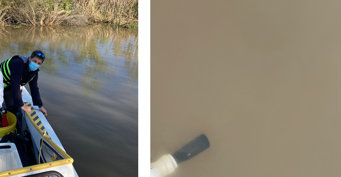
Delta-X: In Situ Water Quality Indicators across MRD, LA, USA, 2021, Version 2
National Aeronautics and Space Administration —
This dataset provides in situ measurements of water temperature (degrees C), salinity (PSU), turbidity (FNU), and chlorophyll-a fluorescence (RFU) in surface of the... -
Federal
GPM SSMI on F08 Common Calibrated Brightness Temperatures L1C 1.5 hours 13 km V07 (GPM_1CF08SSMI) at GES DISC
National Aeronautics and Space Administration —
All 1C products have a common L1C data structure, simple and generic. Each L1C swath includes scan time, latitude and longitude, scan status, quality, incidence... -
Federal
IBEX High Energy Neutral Atom Imager (ENA-Hi) Data Release 10, not Compton-Getting corrected, Survival Probability corrected, Ram direction, West Longitude Ecliptic Maps, 1 year averaged data, Level H3
National Aeronautics and Space Administration —
This IBEX-Hi data set is from Release 10 of all-sky map data for the first seven years, 2009-2015, in the form of ram direction Hydrogen, H, energetic neutral atom... -
Federal
IBEX High Energy Neutral Atom Imager (ENA-Hi) Data Release 10, Compton-Getting corrected, not Survival Probability corrected, Ram direction, West Longitude Ecliptic Maps, 1 year averaged data, Level H3
National Aeronautics and Space Administration —
This IBEX-Hi data set is from Release 10 of all-sky map data for the first seven years, 2009-2015, in the form of ram direction Hydrogen, H, energetic neutral atom... -
Federal
IBEX High Energy Neutral Atom Imager (Hi) Data Release 04, not Compton-Getting corrected, not Survival Probability corrected, Ram direction, West Longitude Ecliptic Maps, Level H3 (H3), annually averaged Data
National Aeronautics and Space Administration —
1: The Interstellar Boundary Explorer (IBEX) has operated in space since 2008 updating our knowledge of the outer heliosphere and its interaction with the local... -
Federal
SMODE L4 ROMS Model Output Version 1
National Aeronautics and Space Administration —
This dataset contains output data files for the Sub-Mesoscale Ocean Dynamics Experiment (S-MODE) Regional Ocean Modelling System (ROMS) model runs. S-MODE aims to... -
Federal
MODIS/Aqua Snow Cover Daily L3 Global 500m SIN Grid V061 NGDA
National Aeronautics and Space Administration —
This global Level-3 (L3) data set provides a daily composite of snow cover and albedo derived from the 'MODIS/Aqua Snow Cover 5-Min L2 Swath 500m' data set...

Official websites use .gov
A
.gov website belongs to an official government
organization in the United States.
Secure .gov websites use HTTPS
A
lock (
) or https:// means you’ve safely connected to
the .gov website. Share sensitive information only on official,
secure websites.