
-
Federal
Archive of Census Related Products (ACRP): 1990 Public Use Microdata Sample Areas (PUMA) Boundary Files
National Aeronautics and Space Administration —
The 1990 Public Use Microdata Sample Areas (PUMA) Boundary Files portion of the Archive of Census Related Products (ACRP) consists of 5% sample (apuma) and 1% sample... -
Federal
Gridded Population of the World, Version 3 (GPWv3): Population Density Grid, Future Estimates
National Aeronautics and Space Administration —
The Gridded Population of the World, Version 3 (GPWv3): Population Density Grid, Future EstimatesFuture Estimates consists of estimates of human population for the... -
Federal
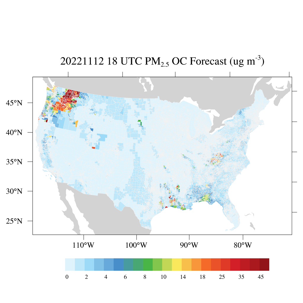
HAQES 3-Hourly Ensemble mean surface PM2.5 Organic Carbon concentration at census level, North America V1 (HAQES_NA_PM25_OC_CENSUS) at GES DISC
National Aeronautics and Space Administration —
This product provides HAQES 3-hourly ensemble mean surface PM2.5 Organic Carbon concentration at the census level over the continental United States (CONUS). The... -
Federal
Star Formation in Nearby Clouds (SFiNCs) Probable Cluster Members Catalog
National Aeronautics and Space Administration —
The Star Formation in Nearby Clouds (SFiNCs) project is aimed at providing a detailed study of the young stellar populations and of star cluster formation in the... -
Federal
Archive of Census Related Products (ACRP): 1980 SAS Transport Files
National Aeronautics and Space Administration —
The 1980 SAS Transport Files portion of the Archive of Census Related Products (ACRP) contains housing and population demographics from the 1980 Summary Tape File... -
Federal
Midcourse Space Experiment (MSX) Point Source Catalog, V2.3
National Aeronautics and Space Administration —
This table contains the main catalog from Version 2.3 of the Midcourse Space Experiment (MSX) Point Source Catalog (PSC), which supersedes the previous version (1.2)... -
Federal
NuSTAR COSMOS Field X-Ray Source Catalog
National Aeronautics and Space Administration —
To provide the census of the sources contributing to the X-ray background peak above 10 keV, the Nuclear Spectroscopic Telescope Array (NuSTAR) is performing... -
Federal
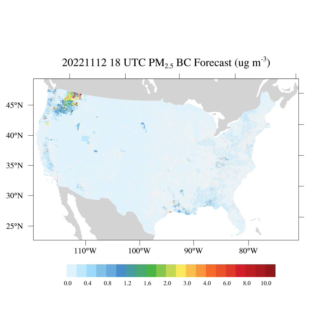
HAQES 3-Hourly Ensemble mean surface PM2.5 Black Carbon concentration at census level, North America V1 (HAQES_NA_PM25_BC_CENSUS) at GES DISC
National Aeronautics and Space Administration —
This product provides HAQES 3-hourly ensemble mean surface PM2.5 Black Carbon concentration at the census level over the continental United States (CONUS). The... -
Federal
U.S. Census Grids (Summary File 3), 1990
National Aeronautics and Space Administration —
The U.S. Census Grids (Summary File 3), 1990 data set contains grids of demographic and socioeconomic data from the year 1990 U.S. census in ASCII and GeoTIFF... -
Federal
Archive of Census Related Products (ACRP): 1990 SAS Transport Files
National Aeronautics and Space Administration —
The 1990 SAS Transport Files portion of the Archive of Census Related Products (ACRP) contains housing and population data from the U.S. Census Bureau's 1990 Summary... -
Federal
MassiveYoungStar-FormingComplexStudyinIR&X-Rays:Mid-IRSourceCatalogs
National Aeronautics and Space Administration —
Spitzer IRAC observations and stellar photometric catalogs are presented for the Massive Young star-forming complex Study in the Infrared and X-ray (MYStIX). MYStIX... -
Federal
Lepine and Shara Northern Stars Proper Motion (LSPM-North) Catalog
National Aeronautics and Space Administration —
The LSPM catalog is a comprehensive list of 61,977 stars north of the J2000 celestial equator that have proper motions larger than 0.15" yr-1 (local-background-stars... -
Federal
LBA-ECO CD-10 Tree DBH Measurements at the km 67 Tower Site, Tapajos National Forest
National Aeronautics and Space Administration —
This data sets reports diameter at breast height (DBH) measurements in the old-growth upland forest at the Para Western (Santarem) - km 67, Primary Forest Tower Site.... -
Federal
Low Elevation Coastal Zone (LECZ) Urban-Rural Population and Land Area Estimates, Version 2
National Aeronautics and Space Administration —
The Low Elevation Coastal Zone (LECZ) Urban-Rural Population and Land Area Estimates, Version 2 data set consists of country-level estimates of urban population,... -
Federal
Gridded Population of the World, Version 3 (GPWv3): Population Count Grid, Future Estimates
National Aeronautics and Space Administration —
The Gridded Population of the World, Version 3 (GPWv3): Population Count Grid, Future Estimates consists of estimates of human population for the years 2005, 2010,... -
Federal
Chamaeleon I North Cloud Chandra X-Ray Point Source Catalog
National Aeronautics and Space Administration —
This table contains the Chamaeleon (Cha) I North Cloud Chandra X-Ray point source catalog. Sensitive X-ray imaging surveys provide a new and effective tool to... -
Federal
NGC 2244/Rosette Nebula Chandra X-Ray Point Source Catalog
National Aeronautics and Space Administration —
This table contains the point source catalog based on the first high spatial resolution X-ray study of NGC 2244, the 2 Myr old stellar cluster in the Rosette Nebula,... -
Federal
U.S. Census Grids (Summary File 1), 1990: Metropolitan Statistical Areas
National Aeronautics and Space Administration —
The U.S. Census Grids (Summary File 1), 1990: Metropolitan Statistical Areas data set contains grids of demographic and socioeconomic data from the year 1990 U.S.... -
Federal
LBA-ECO LC-24 Historical Roads of the Legal Amazon: 1968-1993
National Aeronautics and Space Administration —
Understanding the impact of road investments on deforestation is part of a complete evaluation of the expansion of infrastructure for development.We find evidence of... -
Federal
NPP Tropical Forest: Barro Colorado, Panama, 1969-1990, R1
National Aeronautics and Space Administration —
This data set contains three ASCII files (.txt format). One file provides net primary productivity (NPP) data for the moist lowland tropical forest on Barro Colorado...

Official websites use .gov
A
.gov website belongs to an official government
organization in the United States.
Secure .gov websites use HTTPS
A
lock (
) or https:// means you’ve safely connected to
the .gov website. Share sensitive information only on official,
secure websites.