
-
Federal
Biomass Burning 5x5 degree data in Native Format
National Aeronautics and Space Administration —
The BIO_MASS_5X5_HAO_NAT data set contains data representing the geographical and temporal distribution of total amount of biomass burned. The data were collected by... -
Federal
SERVIR Data Catalog
National Aeronautics and Space Administration —
SERVIR is a Spanish acronym for 'Regional Visualization and Monitoring System.' The SERVIR project enables the use of Earth observations and predictive models for... -
Federal
West Africa Coastal Vulnerability Mapping: Subset of OpenStreetMap (OSM) Roads
National Aeronautics and Space Administration —
The West Africa Coastal Vulnerability Mapping: Subset of OpenStreetMap (OSM) Roads data set includes roads within 200 kilometers of the coast and was extracted from... -
Federal
Improved Simulations of Biomass Burning Aerosol Optical Properties and Lifetimes during the ORACLES-I Campaign: Results from the NASA GEOS Model
National Aeronautics and Space Administration —
This dataset contains model results and satellite-based research retrievals associated with the manuscript submitted in Atmospheric Chemistry and Physics Journal,... -
Federal
SDG Indicator 7.1.1: Access to Electricity, 2023 Release
National Aeronautics and Space Administration —
The SDG Indicator 7.1.1: Access to Electricity, 2023 Release data set, part of the Sustainable Development Goal Indicators (SDGI) collection, measures the proportion... -
Federal
AfriSAR LVIS L1B Geolocated Return Energy Waveforms V001
National Aeronautics and Space Administration —
This data set contains return energy waveform data over Gabon, Africa. The measurements were taken by the NASA Land, Vegetation, and Ice Sensor (LVIS), an airborne... -
Federal
West Africa Coastal Vulnerability Mapping: Gridded Subset of Sub-national Poverty and Extreme Poverty Prevalence
National Aeronautics and Space Administration —
The West Africa Coastal Vulnerability Mapping: Gridded Subset of Sub-national Poverty and Extreme Poverty Prevalence represents the HarvestChoice Subnational Poverty... -
Federal
NAMMA ATD LIGHTNING DATA V1
National Aeronautics and Space Administration —
The NAMMA ATD Lightning data provided by the UK Meterological Office from multiple outstations contains lightning stroke data, latitude and longitude, accuracy and... -
Federal
SAFARI 2000 AERONET-derived Diffuse Spectral Irradiance for Eight Core Sites
National Aeronautics and Space Administration —
This data set contains monthly mean values of diffuse irradiance fraction [f(Ediff), or ratio of diffuse-to-total irradiance] at ground level for a 30-degree solar... -
Federal
SAFARI 2000 Airborne Sunphotometer Aerosol Optical Depth and Water Vapor Data
National Aeronautics and Space Administration —
The NASA Ames Airborne Tracking 14-channel Sunphotometer (AATS-14) was operated successfully aboard the University of Washington CV-580 for 24 data flights during the... -
Federal
SAFARI 2000 SeaWiFS Images for the Southern African Region, 1999-2001
National Aeronautics and Space Administration —
This data set contains Sea-viewing Wide Field-of-view Sensor (SeaWiFS) imagery for the southern African region. These images are Level-1a swaths of the southern... -
Federal
SAFARI 2000 Vegetation and Soils, 1-Deg (Wilson and Henderson-Sellers)
National Aeronautics and Space Administration —
This data set contains a subset for southern Africa of Wilson and Henderson-Sellers' Global Vegetation & Soils 1-degree data. The data are available in both ASCII... -
Federal
SAFARI 2000 MAPSS MOD05_L2 Water Vapor Summary Data for Southern Africa
National Aeronautics and Space Administration —
The Moderate Resolution Imaging Spectroradiometer (MODIS) Atmosphere Group develops remote-sensing algorithms for deriving sets of atmospheric parameters from MODIS... -
Federal
SAFARI 2000 MISR Level 2 Data, Southern Africa, Dry Season 2000
National Aeronautics and Space Administration —
MISR (Multi-angle Imaging SpectroRadiometer) views the sunlit Earth simultaneously at nine widely spaced and collects global images with high spatial detail in four... -
Federal
SAFARI 2000 Monthly Climatology for the 20th Century (New et al.)
National Aeronautics and Space Administration —
This is a data set of mean monthly surface climate data over Southern Africa for nearly all of the twentieth century. The data set is gridded at 0.5 degree... -
Federal
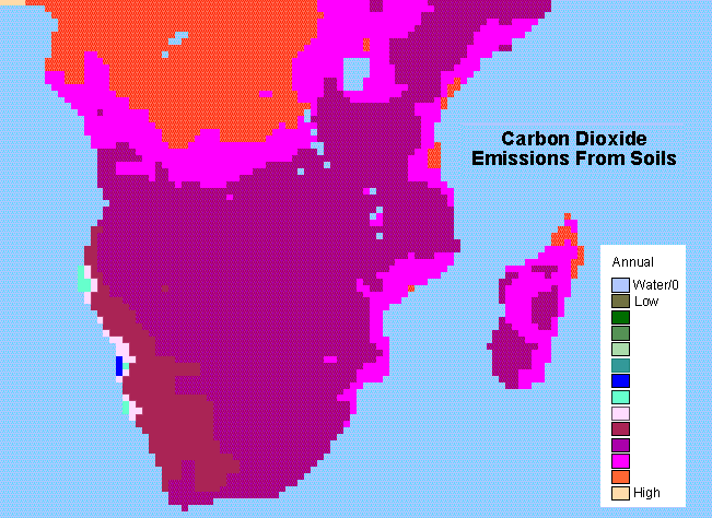
SAFARI 2000 Monthly and Annual CO2 Emissions from Soil, 0.5 Degree Grid
National Aeronautics and Space Administration —
The data set provides estimated monthly and annual soil CO2 emissions for southern Africa (the SAFARI 2000 project region). The calculated emissions are from the... -
Federal
SAFARI 2000 AVHRR-derived Land Surface Temperature Maps, Africa, 1995-2000
National Aeronautics and Space Administration —
Land Surface Temperature (LST) is a key indicator of land surface states, and can provide information on surface-atmosphere heat and mass fluxes, vegetation water... -
Federal
SAFARI 2000 BRDF Measurements at Sua Pan and Skukuza, Dry Season 2000
National Aeronautics and Space Administration —
The Jet Propulsion Laboratory's (JPL) Portable Apparatus for Rapid Acquisition of Bidirectional Observation of the Land and Atmosphere (PARABOLA), version III,... -
Federal
SAFARI 2000 Plant and Soil C and N Isotopes, Southern Africa, 1995-2000
National Aeronautics and Space Administration —
This data set contains measurements of the concentration and stable carbon (13C / 12C) and nitrogen (15N / 14N) isotope ratios of plant (leaves, roots and fungi) and... -
Federal
SAFARI 2000 FEWS 10-day Rainfall Estimate, 8-Km, 1999-2001
National Aeronautics and Space Administration —
The U.S. Agency for International Development (USAID) Famine Early Warning System (FEWS) has been supporting the production of 10-day Rainfall Estimate (RFE) data for...

Official websites use .gov
A
.gov website belongs to an official government
organization in the United States.
Secure .gov websites use HTTPS
A
lock (
) or https:// means you’ve safely connected to
the .gov website. Share sensitive information only on official,
secure websites.