
-
Federal
Sloan Digital Sky Survey I/II Cataclysmic Variables Catalog
National Aeronautics and Space Administration —
The reference paper completed the series of cataclysmic variables (CVs) identified from the Sloan Digital Sky Survey (SDSS) I and II. The coordinates, magnitudes, and... -
Federal
M 51 Chandra X-Ray Discrete Source Catalog
National Aeronautics and Space Administration —
This table contains the results of two Chandra observations (separated by 1 year) of the population of X-ray sources in the spiral galaxy M 51 (NGC 5194 and NGC... -
Federal
BeppoSAX High-Energy Large Area Survey (HELLAS) Radio Source Catalog
National Aeronautics and Space Administration —
This table contains results of a complete radio follow-up obtained with the VLA and ATCA radio telescopes down to a 6-cm flux limit of about 0.3 mJy (3-sigma) of all... -
Federal
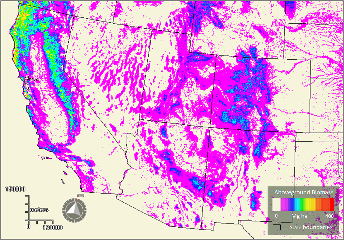
Forest Aboveground Biomass for the Southwestern U.S. from MISR, 2000-2021
National Aeronautics and Space Administration —
This dataset provides estimates of forest aboveground biomass (AGB; in Mg ha-1) at a resolution of 250 m for the southwestern United States over the time period... -
Federal
Global Annual Soil Respiration Data (Raich and Schlesinger 1992)
National Aeronautics and Space Administration —
This data set is a compilation of soil respiration rates (g C m-2 yr-1) from terrestrial and wetland ecosystems reported in the literature prior to 1992. These rates... -
Federal
GHRSST Level 3C Indian-Ocean (IO) sub-skin Sea Surface Temperature from the Spinning Enhanced Visible and Infrared Imager (SEVIRI) on MSG in GDS2 format produced by OSISAF
National Aeronautics and Space Administration —
This dataset is produced by the Ocean and Sea Ice Satellite Application Facility (OSI SAF) from the Spinning Enhanced Visible and InfraRed Imager (SEVIRI) instrument... -
Federal
2dF QSO Redshift (2QZ) Survey
National Aeronautics and Space Administration —
The final catalog of the 2dF QSO Redshift Survey (2QZ) is based on Anglo-Australian Telescope 2dF spectroscopic observations of 44,576 color-selected (u, bJ, r)... -
Federal
GHRSST Level 3U Global Subskin Sea Surface Temperature version 8a from the Advanced Microwave Scanning Radiometer 2 on the GCOM-W satellite
National Aeronautics and Space Administration —
GDS2 Version -The Advanced Microwave Scanning Radiometer 2 (AMSR2) was launched on 18 May 2012, onboard the Golbal Change Observation Mission - Water (GCOM-W)... -
Federal
GHRSST Level 3U Global Subskin Sea Surface Temperature version 8.2 from the Advanced Microwave Scanning Radiometer 2 on the GCOM-W satellite by REMSS
National Aeronautics and Space Administration —
This product contains a “Final” (Refined) Level-3U Sea Surface Temperature (SST) (currently identified by "v8.2" within the file name) for the Group for High... -
Federal
GHRSST Level 3U NOAA ACSPO SST v2.80 from VIIRS on NOAA-21 Satellite
National Aeronautics and Space Administration —
The N21-VIIRS-L3U-ACSPO-v2.80 dataset produced by the NOAA ACSPO system derives the Subskin Sea Surface Temperature (SST) from the Visible Infrared Imaging Radiometer... -
Federal
GHRSST Level 3U NOAA STAR SST v2.80 from VIIRS on NOAA-20 Satellite
National Aeronautics and Space Administration —
NOAA-20 (N20/JPSS-1/J1) is the second satellite in the US NOAA latest generation Joint Polar Satellite System (JPSS), launched on November 18, 2017. The ACSPO... -
Federal
FIREX-AQ MACH2 Surface Mobile In-Situ Measurements
National Aeronautics and Space Administration —
FIREXAQ_SurfaceMobile_MACH2_InSitu_Data are in-situ measurements collected via the NASA Langley Aerosol Research Group mobile platform (MACH2) during FIREX-AQ.... -
Federal
Eddy Corr. Surface Flux: UK (FIFE)
National Aeronautics and Space Administration —
Surface flux measurements were made at selected sites within the FIFE study area. Each surface flux station was capable of measuring the fluxes of net radiation,... -
Federal
Uhuru Fourth (4U) Catalog
National Aeronautics and Space Administration —
The Fourth Uhuru (4U) Catalog lists 339 X-ray sources that were observed with the Uhuru (SAS A) X-ray observatory. It contains positional information in the form of... -
Federal
ChaMP Extended Stellar Survey (ChESS) X-Ray Catalog
National Aeronautics and Space Administration —
The ChaMP Extended Stellar Survey (ChESS) X-ray catalog contains 348 X-ray-emitting stars identified from correlating the Extended Chandra Multiwavelength Project... -
Federal
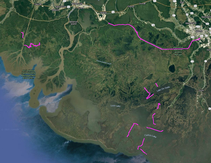
Delta-X: In-situ Water Surface Elevation, MRD, Louisiana, USA, 2021
National Aeronautics and Space Administration —
This dataset contains in situ water level measurements collected at 49 different locations across the Atchafalaya and Terrebonne basins in the Mississippi River Delta... -
Federal
Murchison Widefield Array 32-T Low-Frequency Source Catalog
National Aeronautics and Space Administration —
The Murchison Widefield Array (MWA) is a new low-frequency, wide-field-of-view radio interferometer under development at the Murchison Radio-astronomy Observatory in... -
Federal
Australia Telescope Chandra Deep Field-South and SDSS Stripe 82 20-GHz Sources
National Aeronautics and Space Administration —
This table contains a source catalog, one of the first results from a deep, blind radio survey carried out at 20 GHz with the Australia Telescope Compact Array, with... -
Federal
Midcourse Space Experiment (MSX) Point Source Catalog, V2.3
National Aeronautics and Space Administration —
This table contains the main catalog from Version 2.3 of the Midcourse Space Experiment (MSX) Point Source Catalog (PSC), which supersedes the previous version (1.2)... -
Federal
Small Magellanic Cloud XMM-Newton Point Source Catalog
National Aeronautics and Space Administration —
The XMM-Newton survey of the Small Magellanic Cloud (SMC) yielded complete coverage of the bar and eastern wing in the 0.2-12.0 keV energy band. In addition to the...

Official websites use .gov
A
.gov website belongs to an official government
organization in the United States.
Secure .gov websites use HTTPS
A
lock (
) or https:// means you’ve safely connected to
the .gov website. Share sensitive information only on official,
secure websites.