
-
Federal
Global Maps of Atmospheric Nitrogen Deposition, 1860, 1993, and 2050 10 recent views
National Aeronautics and Space Administration —
This data set provides global gridded estimates of atmospheric deposition of total inorganic nitrogen (N), NHx (NH3 and NH4+), and NOy (all oxidized forms of nitrogen... -
Federal
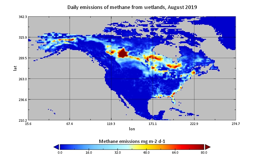
CMS: Global 0.5-deg Wetland Methane Emissions and Uncertainty (WetCHARTs v1.3.1)
National Aeronautics and Space Administration —
This dataset provides global monthly wetland methane (CH4) emissions estimates at 0.5 by 0.5-degree resolution for the period 2001-2019 that were derived from an... -
Federal
Methane Emissions from Dairy Sources (Vista-CA), State of California, USA, 2019
National Aeronautics and Space Administration —
This dataset provides estimates of methane (CH4) emissions from dairies in California at a resolution of 0.1 degrees (~ 10 km x 10 km) for the year 2019. The mapped... -
Federal
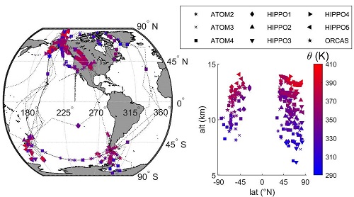
ATom: CAM-chem/CESM2 Model Outputs Along Flight Tracks, 2016-2018
National Aeronautics and Space Administration —
This dataset contains CAM-chem (Community Atmosphere Model with Chemistry) model outputs along ATom flight tracks. CAM-chem is a component of the Community Earth... -
Federal
ACT-America: L2 Remotely Sensed Column-avg CO2 by Airborne Lidar, Lite, Eastern USA
National Aeronautics and Space Administration —
This dataset provides a direct subset (i.e., the Lite version) of the Level 2 (L2) remotely sensed column-average carbon dioxide (CO2) concentrations measured during... -
Federal
Vulcan: High-Resolution Annual Fossil Fuel CO2 Emissions in USA, 2010-2015, Version 3
National Aeronautics and Space Administration —
The Vulcan version 3.0 annual dataset provides estimates of annual carbon dioxide (CO2) emissions from the combustion of fossil fuels (FF) and CO2 emissions from... -
Federal
ATom: Age of Air, ArN2 Ratio, and Trace Gases in Stratospheric Samples, 2009-2018
National Aeronautics and Space Administration —
This dataset provides calculated age of air (AoA) and the argon/nitrogen (Ar/N2) ratio (per meg) from stratospheric flask samples and simultaneous high-frequency... -
Federal
Tundra Plant Reflectance, CO2 Exchange, PAM Fluorometry, and Pigments, AK, 2001-2002
National Aeronautics and Space Administration —
This dataset provides measurements at tundra plots collected near Utqiagvik and Atqasuk, AK, including visible-near infrared spectral reflectance, chamber gas... -
Federal
Global-Gridded Daily Methane Emissions from Inland Dam-Reservoir Systems
National Aeronautics and Space Administration —
This dataset includes global maps of methane (CH4) emissions from inland dam-reservoir systems at 0.25-degree spatial resolution. Daily emission rates (as grams of... -
Federal
Burned and Unburned Field Site Data, Noatak, Seward, and North Slope, AK, 2016-2018
National Aeronautics and Space Administration —
This dataset includes field measurements from unburned and burned 10 m x 10 m and 1 m x 1 m plots in the Noatak, Seward, and North Slope regions of the Alaskan tundra... -
Federal
ACT-America: L1 Raw, Uncalibrated In-Situ CO2, CO, and CH4 Mole Fractions from Towers
National Aeronautics and Space Administration —
This dataset provides Level 1 (L1) in situ atmospheric carbon dioxide (CO2), carbon monoxide (CO), and methane (CH4) concentrations as measured on a network of... -
Federal
ABoVE: Dall Sheep Lamb Recruitment and Climate Data, Alaska and NW Canada, 2000-2015 NGDA
National Aeronautics and Space Administration —
This dataset contains estimated annual average Dall sheep (Ovis dalli dalli) lamb-to-ewe ratios for each year from 2000-2015 across the full species range in Alaska... -
Federal
AVIRIS-NG L2 Surface Reflectance, Facility Instrument Collection, V1
National Aeronautics and Space Administration —
This dataset contains Level 2 (L2) orthocorrected reflectance from the Airborne Visible / Infrared Imaging Spectrometer-Next Generation (AVIRIS-NG) instrument. This... -
Federal
ABoVE: Burned Area, Depth, and Combustion for Alaska and Canada, 2001-2019 NGDA
National Aeronautics and Space Administration —
This dataset provides annual gridded estimates of fire locations and associated burn fraction per pixel for Alaska and Canada at approximately 500 m spatial... -
Federal
A Global Database of Gas Fluxes from Soils after Rewetting or Thawing, Version 1.0
National Aeronautics and Space Administration —
This database contains information compiled from published studies on gas flux from soil following rewetting or thawing. The resulting database includes 222 field and... -
Federal
Simulated Fine Particulate Matter (PM2.5) Estimates over Alaska, 2001-2015
National Aeronautics and Space Administration —
The dataset provides simulated PM2.5 concentration estimates over Alaska, U.S. PM2.5 (particulate matter with diameter <= 2.5 microns) concentrations in air... -
Federal
NACP: MODIS Daily Land Incident 4-km PAR Images For North America, 2003-2005 NGDA
National Aeronautics and Space Administration —
This data set contains daily Moderate Resolution Imaging Spectroradiometer (MODIS) land incident photosynthetically active radiation (PAR) images over North America... -
Federal
ATom: L2 In Situ Measurements from NOAA Nitrogen Oxides and Ozone (NOyO3) Instrument
National Aeronautics and Space Administration —
This dataset provides in situ concentrations of nitric oxide (NO), nitrogen dioxide (NO2), total reactive nitrogen oxides (NOy), and ozone (O3) measured by the NOAA... -
Federal
ATom: Measurements of Soluble Acidic Gases and Aerosols (SAGA)
National Aeronautics and Space Administration —
Soluble acidic gases and aerosols (SAGA) were collected with two related installations; a mist chamber/ion chromatography (MC/IC) system and a paired bulk aerosol... -
Federal
ACT-America: Profile-based Planetary Boundary Layer Heights, Eastern USA
National Aeronautics and Space Administration —
This dataset provides profile-based estimates of the height to the top of the planetary boundary layer (PBL), also known as the atmospheric boundary layer (ABL), in...

Official websites use .gov
A
.gov website belongs to an official government
organization in the United States.
Secure .gov websites use HTTPS
A
lock (
) or https:// means you’ve safely connected to
the .gov website. Share sensitive information only on official,
secure websites.