

25 datasets found
-
Federal
Maximum demand charge rates for commercial and industrial electricity tariffs in the United States
Department of Energy —
NREL has assembled a list of U.S. retail electricity tariffs and their associated demand charge rates for the Commercial and Industrial sectors. The data was obtained... -
Federal
Utah FORGE: Phase 2C Seismic Observation and Ground Water Well Data and Well Locations
Department of Energy —
This submission contains the following data associated with Utah FORGE Phase 2C within the Roosevelt Hot Springs geothermal area: - An ArcGIS shapefile with well... -
Federal
Snake River Plain FORGE: Site Characterization Data
Department of Energy —
The site characterization data used to develop the conceptual geologic model for the Snake River Plain site in Idaho, as part of phase 1 of the Frontier Observatory... -
Federal
Appalachian Basin Play Fairway Analysis: Natural Sedimentary Reservoirs Data 2016 Revision
Department of Energy —
Tier 3 data for Appalachian Basin sectors of New York, Pennsylvania and West Virginia used in a Geothermal Play Fairway Analysis of opportunities for low-temperature... -
Federal
Utah FORGE: Regional Well Locations
Department of Energy —
This archive contains a GIS point feature shapefile that shows the locations of wells in the general region of the Utah FORGE project, near Roosevelt Hot Springs.... -
Federal
Fallon FORGE: GIS and Downhole Well Lithology Data
Department of Energy —
ArcGIS Map Package with MT Station Locations, 2D Seismic Lines, Well data, Known Regional Hydrothermal Systems, Regional Historic Earthquake Seismicity, Regional... -
Federal
UTM Well Coordinates for the Boise Hydrogeophysical Research Site (BHRS)
Department of Energy —
A series of oscillatory pumping tests were performed at the BHRS. The data collected from these wells will be used to tomographically image the shallow subsurface.... -
Federal
Utah FORGE: Well 78-32 Capacity Test
Department of Energy —
This dataset includes an Excel spreadsheet with Utah FORGE Phase 2c Well 78-32 capacity data. It also includes a readme file discussing the data which also includes... -
Federal
Map of Validation of Innovative Exploration Technologies for Newberry Volcano
Department of Energy —
A map showing location of wells permitted, drilled and seismic test, as part of validation of innovative exploration technologies done for the Newberry Volcano... -
Federal
New Mexico Geothermal Play Fairway Analysis from LANL
Department of Energy —
This submission contains geospatial (GIS) data on water table gradient and depth, subcrop gravity and magnetic, propsectivity, heat flow, physiographic, boron and BHT... -
Federal
RivGen Acoustic Measurements, Igiugig, AK
Department of Energy —
Drifting hydrophone measurements obtained around the Ocean Renewable Power Company RivGen turbine near the village of Igiugig, Alaska in August, 2014. Each data set... -
Federal
Seismic Line Location Map File, Hot Pot Project, Humboldt County, Nevada 2010
Department of Energy —
Location of seismic lines carried out under DOE funded project Advanced Seismic Data Analysis Program (The Hot Pot Project). ArcGIS map package containing topographic... -
Federal
Northwest National Marine Renewable Energy Center, OR - Project Plans
Department of Energy —
Plans for Northwest National Marine Renewable Energy Center (NNMREC) Project. Mobile Ocean Test Berth (MOTB) plans PMEC-SETS Plans -
Federal
Brady Geothermal Field PoroTomo Laboratory Deployment Map
Department of Energy —
Map of the PoroTomo Laboratory at Brady Field, Nevada. Map includes locations of GPS Stations, Shaker Stations, Vibroseis Sites, Seismometers, Fiber-Optic Cables, and... -
Federal
Utah FORGE: Well 16A(78)-32 2022 Stimulation Microseismic Report
Department of Energy —
This is a Utah FORGE well 16A(78)-32 stimulation microseismic detection and event location report from Silixa LLC. The report covers the digital acoustic sensing... -
Federal
Seismic Line Location Map, Hot Pot Project, Humboldt County, Nevada 2010
Department of Energy —
Seismic Line Location Map Hot Pot Project, Humboldt County, Nevada 2010. Detailed map (pdf) showing topographic base map, Township and Range layer, Oski BLM and... -
Federal
Utah FORGE: Well 16A(78)-32 Planned Trajectory
Department of Energy —
This submission includes an Excel spreadsheet containing the Utah FORGE deep well 16A(78)-32 planned trajectory including UTM coordinates, elevations, and depths from... -
Federal
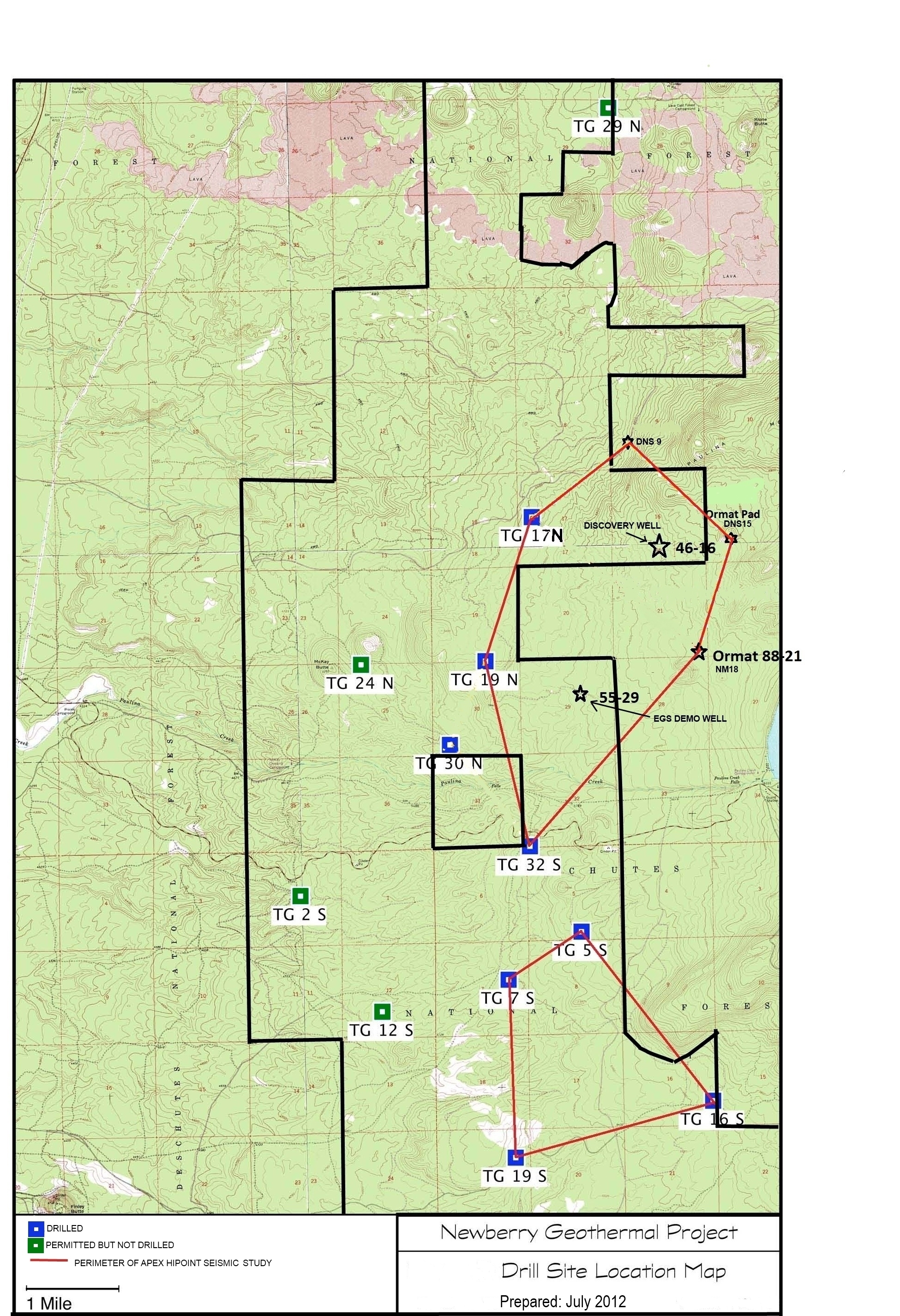
Validation of Innovative Exploration Technologies for Newberry Volcano: Drill Site Location Map
Department of Energy —
Newberry seeks to explore "blind" (no surface evidence) convective hydrothermal systems associated with a young silicic pluton on the flanks of Newberry Volcano. This...
25 datasets found