
-
Federal
Global Land Cover Mapping and Estimation Yearly 30 m V001 recent views
National Aeronautics and Space Administration —
NASA’s Making Earth System Data Records for Use in Research Environments (MEaSUREs) Global Land Cover Mapping and Estimation (GLanCE) annual 30 meter (m) Version 1... -
Federal
ISLSCP II Global Sea Ice Concentration recent views
National Aeronautics and Space Administration —
This International Satellite Land Surface Climatology Project (ISLSCP) Initiative II data set, ISLSCP II Global Sea Ice Concentration, is based on the Goddard Space... -
Federal
REGIONAL AIR-SEA INTERACTION (RASI) GAP WIND AND COASTAL UPWELLING EVENTS CLIMATOLOGY GULF OF PANAMA, PANAMA V1 recent views
National Aeronautics and Space Administration —
The Regional Air-Sea Interactions (RASI) Gap Wind and Coastal Upwelling Events Climatology Gulf of Panama, Panama dataset was created using an automated intelligent... -
Federal
MODIS/Terra+Aqua BRDF Model Parameters Daily L3 Global 1km SIN Grid V061 NGDA recent views
National Aeronautics and Space Administration —
The MCD19A3D Version 6.1 data product is a Moderate Resolution Imaging Spectroradiometer (MODIS) Terra and Aqua combined Bidirectional Reflectance Distribution... -
Federal
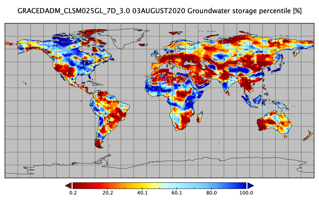
Groundwater and Soil Moisture Conditions from GRACE and GRACE-FO Data Assimilation L4 7-days 0.25 x 0.25 degree Global V3.0 (GRACEDADM_CLSM025GL_7D) at GES DISC recent views
National Aeronautics and Space Administration —
Scientists at NASA Goddard Space Flight Center generate groundwater and soil moisture drought indicators each week. They are based on terrestrial water storage... -
Federal
SMAPVEX16 Iowa Permanent Soil Moisture Network V001 recent views
National Aeronautics and Space Administration —
These data consist of soil moisture, soil temperature and precipitation measurements recorded in 2016 by the permanent soil moisture network; SMAPVEX16-Iowa. The... -
Federal
PalEON: Terrestrial Ecosystem Model Drivers for the Northeastern U.S., 0850-2010 recent views
National Aeronautics and Space Administration —
This dataset from the PalEON Ecosystem Model Intercomparison Project (PEMIP) provides harmonized regional environmental and meteorological drivers at a resolution of... -
Federal
CARVE: L1 In-situ Carbon and CH4 Flux and Meteorology at EC Towers, Alaska, 2011-2015 recent views
National Aeronautics and Space Administration —
This data set provides ground in situ flux and meteorological science data from fixed instruments at three eddy covariance tower sites located in the Alaskan Arctic... -
Federal
High Mountain Asia GFDL FLOR Modeled Extreme Precipitation Indices V001 recent views
National Aeronautics and Space Administration —
This data set features seven standard annual mean extreme precipitation indices: Rx1day, Rx5day, CWD, R10mm, R20mm, R95pTOT, and R99pTOT. They were selected on the... -
Federal
AirMOSS: L4 Modeled Volumetric Root Zone Soil Moisture, 2012-2015 recent views
National Aeronautics and Space Administration —
This data set provides hourly gridded soil moisture estimates derived from hydrologic modeling at nine AirMOSS sites across North America. The AirMOSS L4 RZSM product... -
Federal
REGIONAL AIR-SEA INTERACTION (RASI) GAP WIND AND COASTAL UPWELLING EVENTS CLIMATOLOGY GULF OF TEHUANTEPEC, MEXICO V1 recent views
National Aeronautics and Space Administration —
The Regional Air-Sea Interactions (RASI) Gap Wind and Coastal Upwelling Events Climatology Gulf of Tehuantepec, Mexico dataset was created using an automated... -
Federal
Randolph Glacier Inventory - A Dataset of Global Glacier Outlines, Version 4 NGDA recent views
National Aeronautics and Space Administration —
The Randolph Glacier Inventory (RGI) is a global set of glacier outlines; it is intended as a snapshot of the world’s glaciers. This data set provides a single... -
Federal
ABoVE: Environmental Conditions and Subsistence Resource Access, Alaska, 2016-2017 recent views
National Aeronautics and Space Administration —
This dataset provides descriptions and photos of environmental conditions that impacted availability to subsistence resources by residents in nine rural communities... -
Federal
Nenana Ice Classic: Tanana River Ice Annual Breakup Dates, Version 2 recent views
National Aeronautics and Space Administration —
The Tanana river in the Interior of Alaska usually freezes over during October and November. The ice continues to grow throughout the winter accumulating an average... -
Federal
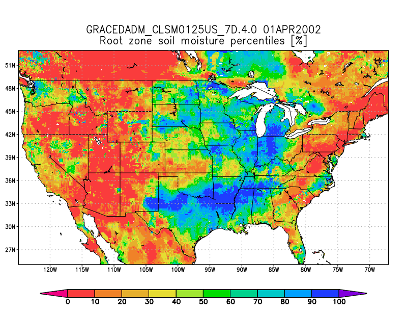
Groundwater and Soil Moisture Conditions from GRACE and GRACE-FO Data Assimilation L4 7-days 0.125 x 0.125 degree U.S. V4.0 (GRACEDADM_CLSM0125US_7D) at GES DISC recent views
National Aeronautics and Space Administration —
Scientists at NASA Goddard Space Flight Center generate groundwater and soil moisture drought indicators each week. They are based on terrestrial water storage... -
Federal
SiB4 Modeled Global 0.5-Degree Hourly Carbon Fluxes and Productivity, 2000-2018 recent views
National Aeronautics and Space Administration —
This dataset provides global hourly output predicted from the Simple Biosphere Model, Version 4.2 (SiB4), at a 0.5-degree spatial resolution covering the time period... -
Federal
Alaska's Changing YK Delta: Knowledge Exchange between Elders and Geoscientists, 2018 recent views
National Aeronautics and Space Administration —
This dataset provides a booklet documenting the discussions and outcomes from a knowledge-exchange meeting with Yup'ik elders from the Yukon-Kuskokwim Delta (YKD),... -
Federal
Tellus Level-4 Ocean Mass Anomaly Time Series from JPL GRACE/GRACE-FO Mascon CRI Filtered Release 06.1 version 03 recent views
National Aeronautics and Space Administration —
This dataset is a time series of mass variability averaged over all of the global ocean. It provides the non-steric or mass only sea level changes over time. The mass...

Official websites use .gov
A
.gov website belongs to an official government
organization in the United States.
Secure .gov websites use HTTPS
A
lock (
) or https:// means you’ve safely connected to
the .gov website. Share sensitive information only on official,
secure websites.