
-
Federal
Global Fire Emissions Database, Version 4.1 (GFEDv4) NGDA
National Aeronautics and Space Administration —
This dataset provides global estimates of monthly burned area, monthly emissions and fractional contributions of different fire types, daily or 3-hourly fields to... -
Federal
MERRA-2 inst3_3d_aer_Nv: 3d,3-Hourly,Instantaneous,Model-Level,Assimilation,Aerosol Mixing Ratio 0.625 x 0.5 degree V5.12.4 (M2I3NVAER) at GES DISC
National Aeronautics and Space Administration —
M2I3NVAER (or inst3_3d_aer_Nv) is an instantaneous 3-dimensional 3-hourly data collection in Modern-Era Retrospective analysis for Research and Applications version 2... -
Federal
Multi-Satellite Air Quality Sulfur Dioxide (SO2) Database Long-Term L4 Global V2 (MSAQSO2L4) at GES DISC
National Aeronautics and Space Administration —
These data are a part of Multi-Decadal Sulfur Dioxide (SO2) Climatology from Satellite Instruments (MEaSUREs-12-0022 project). Version 2 of the global catalogue of... -
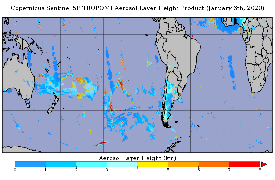
Federal
Sentinel-5P TROPOMI Aerosol Layer Height 1-Orbit L2 5.5km x 3.5km V1 (S5P_L2__AER_LH_HiR) at GES DISC
National Aeronautics and Space Administration —
Starting from August 6th in 2019, Sentinel-5P TROPOMI along-track high spatial resolution (~5.5km at nadir) has been implemented. For data before August 6th of 2019,... -
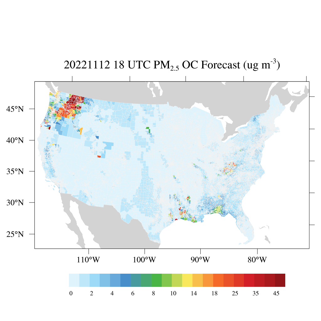
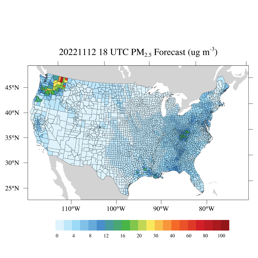
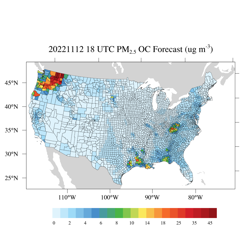
Federal
HAQES 3-Hourly Ensemble mean surface PM2.5 Organic Carbon concentration at census level, North America V1 (HAQES_NA_PM25_OC_CENSUS) at GES DISC
National Aeronautics and Space Administration —
This product provides HAQES 3-hourly ensemble mean surface PM2.5 Organic Carbon concentration at the census level over the continental United States (CONUS). The... -
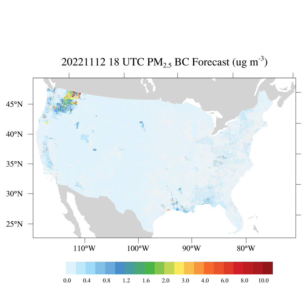
Federal
HAQES 3-Hourly Ensemble mean surface PM2.5 Black Carbon concentration at census level, North America V1 (HAQES_NA_PM25_BC_CENSUS) at GES DISC
National Aeronautics and Space Administration —
This product provides HAQES 3-hourly ensemble mean surface PM2.5 Black Carbon concentration at the census level over the continental United States (CONUS). The... -
Federal
Aqua/AIRS L2 Near Real Time (NRT) Support Retrieval (AIRS-only) V7.0 at GES DISC
National Aeronautics and Space Administration —
The Atmospheric Infrared Sounder (AIRS) Level 2 Near Real Time (NRT) Support Retrieval (AIRS-only) product (AIRS2SUP_NRT_7.0) differs from the routine product... -
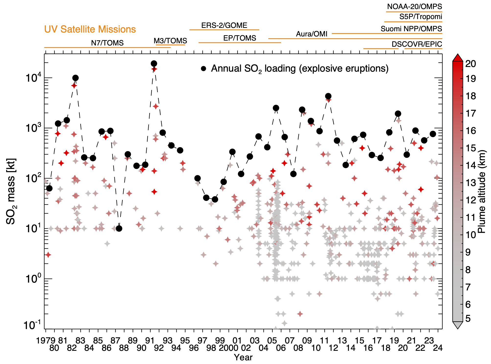
Federal
Multi-Satellite Volcanic Sulfur Dioxide L4 Long-Term Global Database V4 (MSVOLSO2L4) at GES DISC
National Aeronautics and Space Administration —
Version 4 is the current version of the data set. Older versions are no longer available and have been superseded by Version 4. These data are a part of MEaSUREs 2012... -
Federal
HAQES 3-Hourly Ensemble mean surface total PM2.5 concentration at census level, North America V1 (HAQES_NA_PM25_TOT_CENSUS) at GES DISC
National Aeronautics and Space Administration —
This product provides HAQES 3-hourly ensemble mean surface total PM2.5 concentration at the census level over the continental United States (CONUS). The Hazardous Air... -
Federal
HAQES 3-Hourly Ensemble mean surface total PM2.5 concentration at county level, North America V1 (HAQES_NA_PM25_TOT_COUNTY) at GES DISC
National Aeronautics and Space Administration —
This product provides HAQES 3-hourly ensemble mean surface total PM2.5 concentration at the county level over the continental United States (CONUS). The Hazardous Air... -
Federal
HAQES 3-Hourly Ensemble mean surface PM2.5 Organic Carbon concentration at county level, North America V1 (HAQES_NA_PM25_OC_COUNTY) at GES DISC
National Aeronautics and Space Administration —
This product provides HAQES 3-hourly ensemble mean surface PM2.5 Organic Carbon concentration at the county level over the continental United States (CONUS). The... -
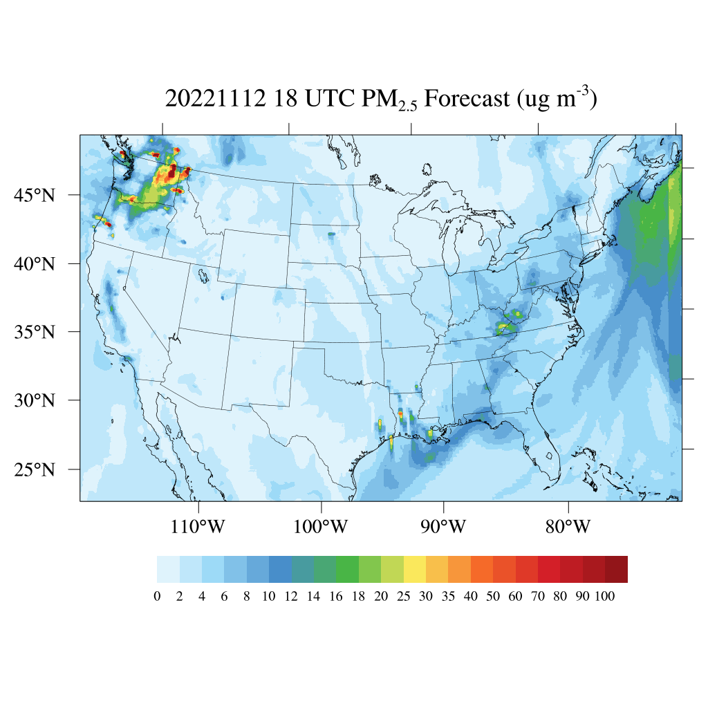
Federal
HAQES 3-Hourly Ensemble mean surface total PM2.5 concentration, North America V1 (HAQES_NA_PM25_TOT) at GES DISC
National Aeronautics and Space Administration —
This product provides HAQES 3-hourly ensemble mean surface total PM2.5 concentration over the continental United States (CONUS) and surrounding regions. The data is... -
Federal
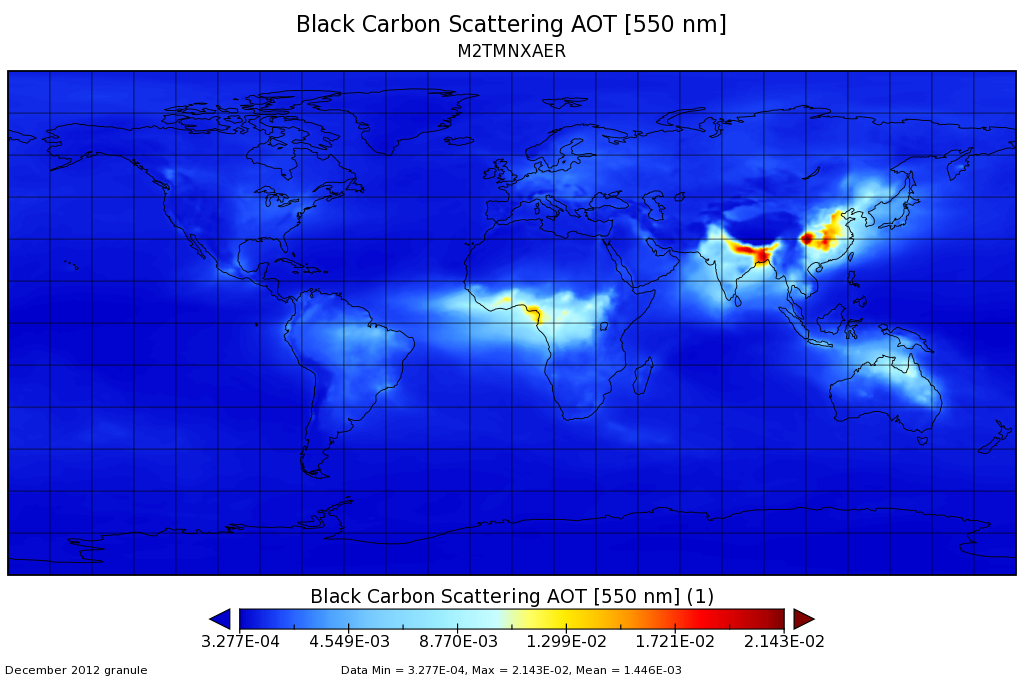
MERRA-2 tavgM_2d_aer_Nx: 2d,Monthly mean,Time-averaged,Single-Level,Assimilation,Aerosol Diagnostics 0.625 x 0.5 degree V5.12.4 (M2TMNXAER) at GES DISC
National Aeronautics and Space Administration —
M2TMNXAER (or tavgM_2d_aer_Nx) is a time-averaged 2-dimensional monthly mean data collection in Modern-Era Retrospective analysis for Research and Applications... -
Federal
ATom: L2 Measurements from CU High-Resolution Aerosol Mass Spectrometer (HR-AMS)
National Aeronautics and Space Administration —
This dataset provides the atmospheric concentrations of separated ions from inorganic and organic species measured by the High-Resolution Aerosol Mass Spectrometer... -
Federal
ATom: Nucleation Mode Aerosol Size Spectrometer Calibration and Performance Data
National Aeronautics and Space Administration —
This dataset provides extensive calibration and in-flight performance data for two nucleation mode aerosol size spectrometer (NMASS) instruments utilized in the NASA... -
Federal
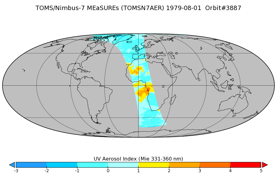
TOMS/N7 Near UV Aerosol Index and LER 1-Orbit L2 50x50 km
National Aeronautics and Space Administration —
As part of the NASA's Making Earth System Data Records for Use in Research Environments (MEaSUREs) program, this projects describes a multi-decadal Fundamental... -
Federal
AMAZE-08 Aerosol Characterization and Meteorological Data, Central Amazon Basin: 2008
National Aeronautics and Space Administration —
This data set provides measurements from the Amazonian Aerosol Characterization Experiment (AMAZE-08) carried out during the wet season from February 4 to March 21,... -
Federal
Sentinel-5P TROPOMI Sulphur Dioxide SO2 1-Orbit L2 5.5km x 3.5km V2 (S5P_L2__SO2____HiR) at GES DISC
National Aeronautics and Space Administration —
Starting from August 6th in 2019, Sentinel-5P TROPOMI along-track high spatial resolution (~5.5km at nadir) has been implemented. Starting from July 13th in 2020,... -
Federal
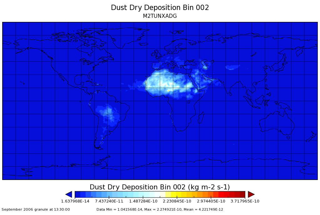
MERRA-2 tavgU_2d_adg_Nx: 2d,diurnal,Time-averaged,Single-Level,Assimilation,Aerosol Diagnostics (extended) 0.625 x 0.5 degree V5.12.4 (M2TUNXADG) at GES DISC
National Aeronautics and Space Administration —
M2TUNXADG (or tavgU_2d_adg_Nx) is a time-averaged 2-dimensional monthly diurnal means data collection in Modern-Era Retrospective analysis for Research and... -
Federal
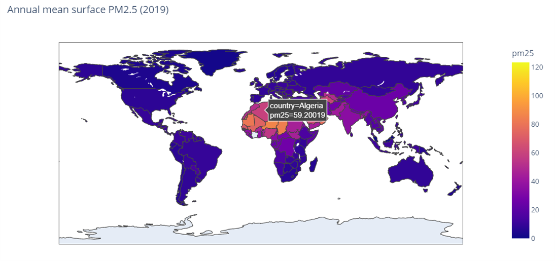
MERRA-2 avgM_2d_pm25_admin0, 2d, Single-Level, Country-Level Surface PM2.5 Monthly Mean Products V1 (M2_TMAX_PM25) at GES DISC
National Aeronautics and Space Administration —
M2_TMAX_PM25 is a value-added product derived from the MERRA-2 aerosol monthly product M2TMNXAER_5.12.4 (or tavgM_2d_aer_Nx). The surface concentration of fine...

Official websites use .gov
A
.gov website belongs to an official government
organization in the United States.
Secure .gov websites use HTTPS
A
lock (
) or https:// means you’ve safely connected to
the .gov website. Share sensitive information only on official,
secure websites.