
-
Federal
Fire Island National Seashore bathymetry survey, 2024.
Department of the Interior —
Multibeam sonar data collected with an EchoBoat 160 (Seafloor Systems inc.), an autonomous surface vessel (ASV), equipped with an iWBMSe mutibeam sonar (Norbit). Data... -
Federal
Crop response and changes in soil properties as affected by soil erosion, topsoil replacement, and application of anaerobically digested dairy manure solids in a Mollisol landform
Department of Agriculture —
These data provide field measurements of plant and soil at a geographical site as affected by (a) tillage and water erosion (b) replacement of translocated topsoil... -
Federal
Tuxedni Channel bathymetric survey 2024-2025, Lake Clark National Park and Preserve
Department of the Interior —
Multibeam sonar data collected with an EchoBoat 160 (Seafloor Systems inc.), an autonomous surface vessel (ASV), equipped with an iWBMSe mutibeam sonar (Norbit). Data... -
Federal
UARS Wind Imaging Interferometer (WINDII) Level 3AT V011 (UARWI3AT) at GES DISC
National Aeronautics and Space Administration —
The Wind Imaging Interferometer (WINDII) Level 3AT data product consists of daily, 65.536 second interval time-ordered vertical profiles of meridional and zonal wind... -
Federal
UARS Correlative UKMO Daily Gridded Stratospheric Assimilated Data V001 (UARZCUKM) at GES DISC
National Aeronautics and Space Administration —
The UARS Correlative assimilation data from the U.K. Meteorological Office (UKMO) consists of daily model runs at 12:00 GMT as a means of providing an independent... -
Federal
UARS Improved Stratospheric and Mesospheric Sounder (ISAMS) Level 3AL V010 (UARIS3AL) at GES DISC
National Aeronautics and Space Administration —
The Improved Stratospheric and Mesospheric Sounder (ISAMS) Level 3AL data product consists of daily, 4 degree increment latitude-ordered vertical profiles of... -
Federal
UARS Solar-Stellar Irradiance Comparison Experiment (SOLSTICE) Level 3BS V018 (UARSO3BS) at GES DISC
National Aeronautics and Space Administration —
The Solar-Stellar Irradiance Comparison Experiment (SOLSTICE) Level 3BS data product consists of daily, 1 nm resolution, solar spectral irradiances and selected solar... -
Federal
2024 KEFJ Pedersen Lagoon Landslide SfM Imagery and GNSS
Department of the Interior —
Orthomosaics and Digital Surface Models of Pedersen Lagoon, the toe of Pedersen Glacier, and surrounding areas in Kenai Fjords National Park. These data were... -
Federal
Baca National Wildlife Refuge and Great Sand Dunes Vegetation Mapping Project
Department of the Interior —
This vegetation classification and mapping effort encompasses 167,148 ha(413,031 acres ) within the San Luis Valley, west of the Sangre de Cristo Mountains in south... -
Federal
Aquatic Health and Climate Change: Long-term Monitoring - Monitoring Sites and USGS Stations
Department of the Interior —
This reference was created to house geospatial data related to Aquatic Health and Climate Change: Long-term Monitoring starting in 2021. This project is the... -
Federal
Charles M. Russell National Wildlife Refuge Fire History GIS Feature Classes
Department of the Interior —
Summary This feature class documents the fire history on CMR from 1964 - present. This is 1 of 2 feature classes, a polygon and a point. This data has a variety of... -
Federal
UARS High Resolution Doppler Imager (HRDI) Level 3AT V011 (UARHR3AT) at GES DISC
National Aeronautics and Space Administration —
The High Resolution Doppler Imager (HRDI) Level 3AT data product consists of daily, 65.536 second interval time-ordered vertical profiles of meridional and zonal wind... -
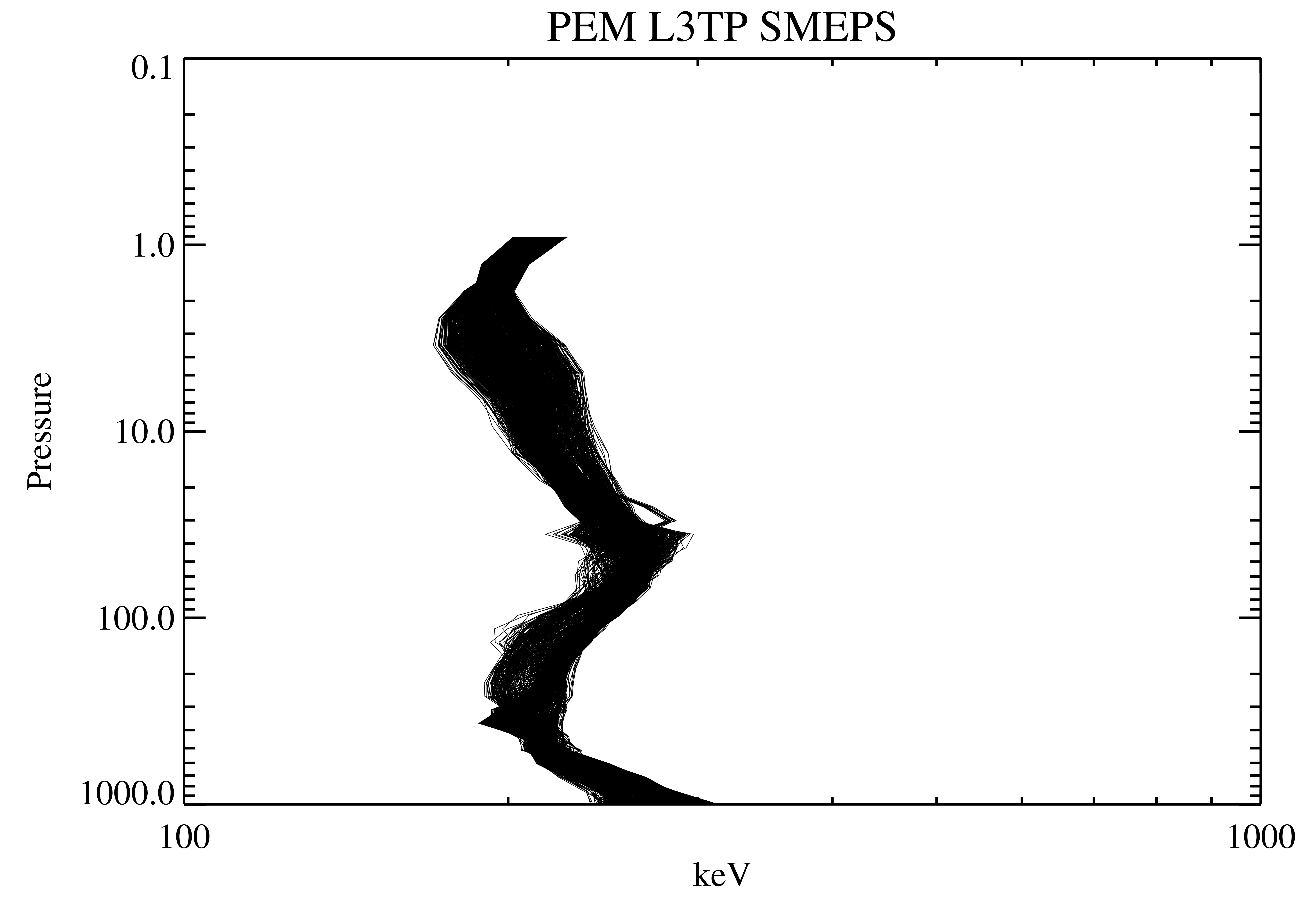
Federal
UARS Particle Environment Monitor (PEM) Level 3TP V004 (UARPE3TP) at GES DISC
National Aeronautics and Space Administration —
The Particle Environment Monitor (PEM) Level 3TP data product consists of daily, 65.536 second and 2.048 interval time-ordered, vertical profiles of electron and... -
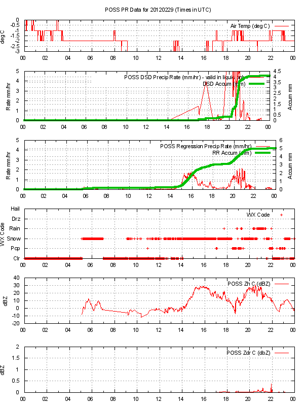
Federal
GPM GROUND VALIDATION ENVIRONMENT CANADA (EC) PRECIPITATION OCCURRENCE SENSOR SYSTEM (POSS) GCPEX V1
National Aeronautics and Space Administration —
The GPM Ground Validation Environment Canada (EC) Precipitation Occurrence Sensor System (POSS) GCPEx dataset is comprised of data gathered during the GPM Cold-season... -
Federal
UARS Correlative NMC Daily Gridded Stratospheric Assimilated Data V001 (UARZCNMC) at GES DISC
National Aeronautics and Space Administration —
The UARS Correlative assimilation data from NOAA's National Meteorological Center (NMC) consists of daily model runs at 12 GMT as a means of providing an independent... -
Federal
2010 NOAA/USGS Lidar: French Frigate Shoals, NWHI
National Oceanic and Atmospheric Administration, Department of Commerce —
The U.S. Geological Survey (USGS) contracted with Hawaii-based Aerial Surveying, Inc. to collect lidar-derived elevation data over the low-lying areas within the... -
Federal
GPM GROUND VALIDATION ENVIRONMENT CANADA (EC) PASSIVE MICROWAVE RADIOMETER AND SOIL MOISTURE-TEMPERATURE DATA GCPEX V1
National Aeronautics and Space Administration —
The GPM Ground Validation Environment Canada (EC) Passive Microwave Radiometer and Soil Moisture-Temperature Data GCPEx dataset is consisted of data during the GPM... -
Federal
UARS Wind Imaging Interferometer (WINDII) Level 3AL V011 (UARWI3AL) at GES DISC
National Aeronautics and Space Administration —
The Wind Imaging Interferometer (WINDII) Level 3AL data product consists of daily, 4 degree increment latitude-ordered vertical profiles of meridional and zonal wind... -
Federal
UARS Particle Environment Monitor (PEM) Level 3AT V004 (UARPE3AT) at GES DISC
National Aeronautics and Space Administration —
The Particle Environment Monitor (PEM) Level 3AT data product consists of daily, 65.536 second interval time-ordered, vertical profiles of electron, proton and x-ray...

Official websites use .gov
A
.gov website belongs to an official government
organization in the United States.
Secure .gov websites use HTTPS
A
lock (
) or https:// means you’ve safely connected to
the .gov website. Share sensitive information only on official,
secure websites.