
-
Federal
Physical Solar Model version 3 Global Horizontal Irradiance Multi-year Annual Average
Department of Energy —
This data provides annual average daily total solar resource averaged over surface cells of 0.038 degrees in both latitude and longitude, or nominally 4 km in size.... -
Federal
EMAG2: Earth Magnetic Anomaly Grid (2-arc-minute resolution)
National Oceanic and Atmospheric Administration, Department of Commerce —
EMAG2 is a global Earth Magnetic Anomaly Grid compiled from satellite, ship, and airborne magnetic measurements. It is a significant update of our previous candidate... -
Federal
F00909: NOS Hydrographic Survey , 2024-09-30
National Oceanic and Atmospheric Administration, Department of Commerce —
The National Oceanic and Atmospheric Administration (NOAA) has the statutory mandate to collect hydrographic data in support of nautical chart compilation for safe... -
University
2011 Las Conchas Post Fire, h435106_nw_nw, CIR
Earth Data Analysis Center, University of New Mexico —
Wilson and Company collected and processed multi-spectral (red, green, blue, near-infrared) digital aerial imagery of the Las Conchas Fire that burned in the Santa Fe... -
Federal
2023 USDA Plant Hardiness Zone Map Mean Annual Extreme Low Temperature Rasters
Department of Agriculture —
These rasters provide the local mean annual extreme low temperature from 1991 to 2020 in an 800m x 800m grid covering the USA (including Puerto Rico) based on... -
Federal
F00918: NOS Hydrographic Survey , 2025-05-07
National Oceanic and Atmospheric Administration, Department of Commerce —
The National Oceanic and Atmospheric Administration (NOAA) has the statutory mandate to collect hydrographic data in support of nautical chart compilation for safe... -
Federal
H07802: NOS Hydrographic Survey , 1951-12-31
National Oceanic and Atmospheric Administration, Department of Commerce —
The National Oceanic and Atmospheric Administration (NOAA) has the statutory mandate to collect hydrographic data in support of nautical chart compilation for safe... -
University
2011 Las Conchas Post Fire, f335106_se_ne, CIR
Earth Data Analysis Center, University of New Mexico —
Wilson and Company collected and processed multi-spectral (red, green, blue, near-infrared) digital aerial imagery of the Las Conchas Fire that burned in the Santa Fe... -
Federal
H06193: NOS Hydrographic Survey , 1937-12-31
National Oceanic and Atmospheric Administration, Department of Commerce —
The National Oceanic and Atmospheric Administration (NOAA) has the statutory mandate to collect hydrographic data in support of nautical chart compilation for safe... -
University
2012 Little Bear Post Fire, Nogal Peak SW NW, RGB
Earth Data Analysis Center, University of New Mexico —
This data set contains imagery for the Lincoln National Forest, Otero County, New Mexico. The imagery was flown to provide coverage after the 2012 Little Bear Fire. -
Federal
H12572: NOS Hydrographic Survey , Delaware Bay and Approaches, 2013-09-16
National Oceanic and Atmospheric Administration, Department of Commerce —
The National Oceanic and Atmospheric Administration (NOAA) has the statutory mandate to collect hydrographic data in support of nautical chart compilation for safe... -
Federal
F00646: NOS Hydrographic Survey , 2014-10-22
National Oceanic and Atmospheric Administration, Department of Commerce —
The National Oceanic and Atmospheric Administration (NOAA) has the statutory mandate to collect hydrographic data in support of nautical chart compilation for safe... -
Federal
H07723: NOS Hydrographic Survey , 1950-12-31
National Oceanic and Atmospheric Administration, Department of Commerce —
The National Oceanic and Atmospheric Administration (NOAA) has the statutory mandate to collect hydrographic data in support of nautical chart compilation for safe... -
University
2011 Las Conchas Post Fire, e435106_nw_ne, CIR
Earth Data Analysis Center, University of New Mexico —
Wilson and Company collected and processed multi-spectral (red, green, blue, near-infrared) digital aerial imagery of the Las Conchas Fire that burned in the Santa Fe... -
Federal
H06520: NOS Hydrographic Survey , 1939-12-31
National Oceanic and Atmospheric Administration, Department of Commerce —
The National Oceanic and Atmospheric Administration (NOAA) has the statutory mandate to collect hydrographic data in support of nautical chart compilation for safe... -
University
2011 Las Conchas Post Fire, a336106_sw_se, CIR
Earth Data Analysis Center, University of New Mexico —
Wilson and Company collected and processed multi-spectral (red, green, blue, near-infrared) digital aerial imagery of the Las Conchas Fire that burned in the Santa Fe... -
Federal
F00919: NOS Hydrographic Survey , 2025-06-03
National Oceanic and Atmospheric Administration, Department of Commerce —
The National Oceanic and Atmospheric Administration (NOAA) has the statutory mandate to collect hydrographic data in support of nautical chart compilation for safe... -
Federal
H04271: NOS Hydrographic Survey , 1922-12-31
National Oceanic and Atmospheric Administration, Department of Commerce —
The National Oceanic and Atmospheric Administration (NOAA) has the statutory mandate to collect hydrographic data in support of nautical chart compilation for safe... -
Federal
F00473D: NOS Hydrographic Survey , San Diego Bay, California, 2001-04-13
National Oceanic and Atmospheric Administration, Department of Commerce —
The National Oceanic and Atmospheric Administration (NOAA) has the statutory mandate to collect hydrographic data in support of nautical chart compilation for safe... -
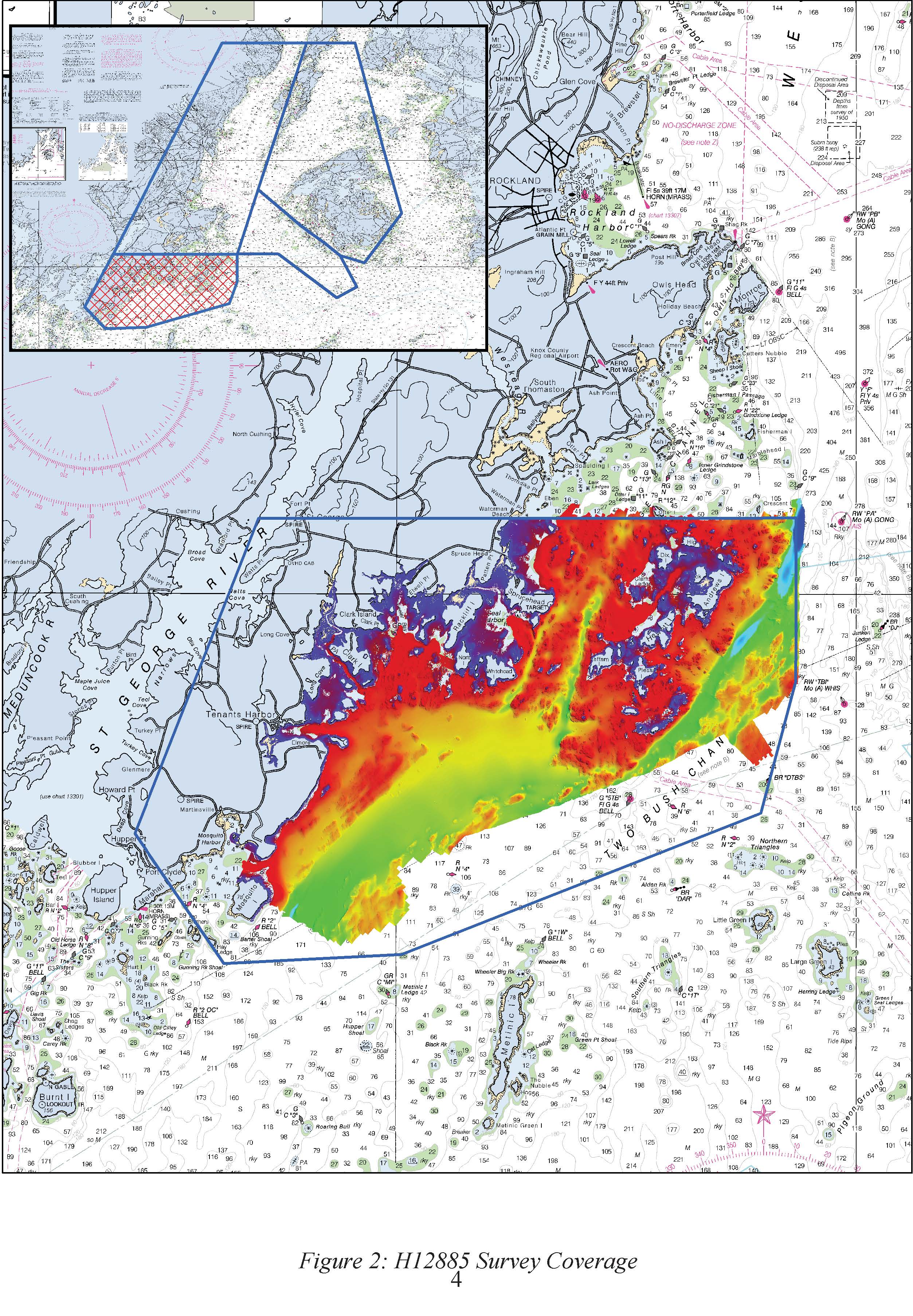
Federal
H12885: NOS Hydrographic Survey , 2016-09-29
National Oceanic and Atmospheric Administration, Department of Commerce —
The National Oceanic and Atmospheric Administration (NOAA) has the statutory mandate to collect hydrographic data in support of nautical chart compilation for safe...

Official websites use .gov
A
.gov website belongs to an official government
organization in the United States.
Secure .gov websites use HTTPS
A
lock (
) or https:// means you’ve safely connected to
the .gov website. Share sensitive information only on official,
secure websites.