
-
Federal
School District Characteristics - Current
Department of Education —
The National Center for Education Statistics’ (NCES) Education Demographic and Geographic Estimate (EDGE) program develops annually updated school district boundary... -
Federal
Public School Locations 2021-22
Department of Education —
The National Center for Education Statistics' (NCES) Education Demographic and Geographic Estimate (EDGE) program develops annually updated point locations (latitude... -
Federal
Public School Characteristics - Current
Department of Education —
The National Center for Education Statistics' (NCES) Education Demographic and Geographic Estimate (EDGE) program develops annually updated point locations (latitude... -
Federal
Public School Characteristics 2017-18
Department of Education —
The National Center for Education Statistics' (NCES) Education Demographic and Geographic Estimate (EDGE) program develops annually updated point locations (latitude... -
Federal
TIGER/Line Shapefile, 2015, nation, U.S., Current Tribal Census Tract National Shapefile
U.S. Census Bureau, Department of Commerce —
The TIGER/Line shapefiles and related database files (.dbf) are an extract of selected geographic and cartographic information from the U.S. Census Bureau's Master... -
Federal
School Neighborhood Poverty Estimates - Current
Department of Education —
The 2020-2021 School Neighborhood Poverty Estimates are based on school locations from the 2020-2021 Common Core of Data (CCD) school file and income data from... -
Federal
Locale - Current
Department of Education —
This data layer produced by the National Center for Education Statistics’ (NCES) Education Demographic and Geographic Estimates (EDGE) program provides a geographic... -
Federal
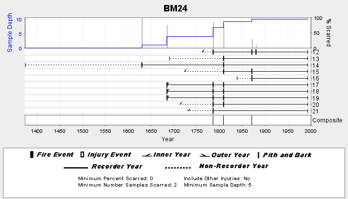
NOAA/WDS Paleoclimatology - Veblen fire data from BM24 - IMPD USBM-024
National Oceanic and Atmospheric Administration, Department of Commerce —
This archived Paleoclimatology Study is available from the NOAA National Centers for Environmental Information (NCEI), under the World Data Service (WDS) for... -
Federal
School District Office Locations 2018-19
Department of Education —
The National Center for Education Statistics' (NCES) Education Demographic and Geographic Estimate (EDGE) program develops annually updated point locations (latitude... -
Federal
National Coral Reef Monitoring Program: Stratified Random Surveys (StRS) of Coral Demography (Adult and Juvenile Corals) across the Hawaiian Archipelago since 2013
National Oceanic and Atmospheric Administration, Department of Commerce —
NCRMP CORAL DEMOGRAPHIC DATA HAS NOW BEEN MERGED INTO A PACIFIC-WIDE METADATA RECORD -- PLEASE REFER TO https://www.fisheries.noaa.gov/inport/item/71550 FOR MOST... -
Federal
Locales 2021
Department of Education —
This data layer produced by the National Center for Education Statistics’ (NCES) Education Demographic and Geographic Estimates (EDGE) program provides a geographic... -
Federal
Social Vulnerability Index (SoVI) for Texas based on 2000 Census Block Groups
National Oceanic and Atmospheric Administration, Department of Commerce —
This data depicts the social vulnerability of Texas census block groups to environmental hazards. Data were culled primarily from the 2000 Decennial Census. -
Federal
AFSC/ABL: ACES-SHELFZ (Arctic Coastal Ecosystem Survey AND Shelf Habitat and EcoLogy of Fish and Zooplankton) Catch Database
National Oceanic and Atmospheric Administration, Department of Commerce —
The objectives of these Arctic nearshore fish surveys is to measure seasonal changes in the distribution, demographics, trophic position and nutritional status of... -
Federal
School District Office Locations 2020-21
Department of Education —
The National Center for Education Statistics' (NCES) Education Demographic and Geographic Estimate (EDGE) program develops annually updated point locations (latitude... -
Federal
Demographic Trends (1970-2010) for Coastal Geographies
National Oceanic and Atmospheric Administration, Department of Commerce —
The Demographic Trends (1970-2010) were derived from Census Block Group Data for 13 different coastal geographies. For a full listing of the geographies available,... -
Federal
Salmonid and Steelhead Population Abundance Summary from 1949 to 2015 for Washington, Oregon, and California
National Oceanic and Atmospheric Administration, Department of Commerce —
The Northwest Fisheries Science Center's (NWFSC) Salmon Population Summary (SPS) database provides public access to demographic data compiled for ESA-listed salmonid... -
Federal
Locales 2020
Department of Education —
This data layer produced by the National Center for Education Statistics’ (NCES) Education Demographic and Geographic Estimates (EDGE) program provides a geographic... -
Federal
School District Characteristics 2020-21
Department of Education —
The National Center for Education Statistics’ (NCES) Education Demographic and Geographic Estimate (EDGE) program develops annually updated school district boundary... -
Federal
National Coral Reef Monitoring Program: Coral demographic data (adult and juvenile corals, species, colony length, condition, etc.) collected during Stratified Random Surveys (StRS) across the US Pacific since 2013 derived from in-situ diver surveys and structure-from-motion imagery
National Oceanic and Atmospheric Administration, Department of Commerce —
The data described here result from benthic coral demographic surveys within belt transects of specified length and width for two life stages (juveniles and adults)... -
Federal
School Neighborhood Poverty Estimates, 2020-21
Department of Education —
The 2020-2021 School Neighborhood Poverty Estimates are based on school locations from the 2020-2021 Common Core of Data (CCD) school file and income data from...

Official websites use .gov
A
.gov website belongs to an official government
organization in the United States.
Secure .gov websites use HTTPS
A
lock (
) or https:// means you’ve safely connected to
the .gov website. Share sensitive information only on official,
secure websites.