
-
Federal
H13682: NOS Hydrographic Survey , 2022-09-21
National Oceanic and Atmospheric Administration, Department of Commerce —
The National Oceanic and Atmospheric Administration (NOAA) has the statutory mandate to collect hydrographic data in support of nautical chart compilation for safe... -
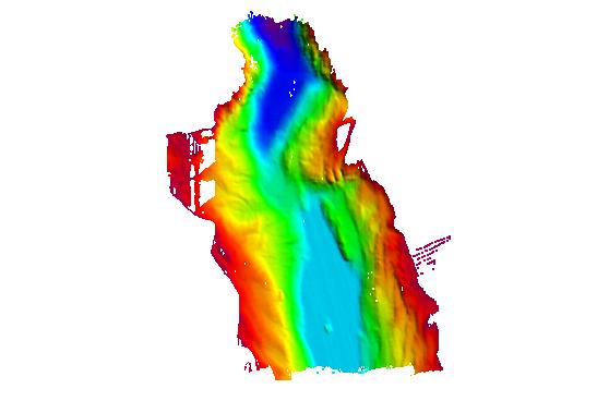
State
Lake Bathymetry Contours Lines
State of Connecticut —
See full Data Guide here. Lake Bathymetry describes the water depth for selected reservoirs, lakes, ponds, and coves in Connecticut. It includes depth contours, also... -
Federal
F00595: NOS Hydrographic Survey , NW Approach to Key West, Florida, 2010-08-23
National Oceanic and Atmospheric Administration, Department of Commerce —
The National Oceanic and Atmospheric Administration (NOAA) has the statutory mandate to collect hydrographic data in support of nautical chart compilation for safe... -
Federal
H13384: NOS Hydrographic Survey , 2021-03-10
National Oceanic and Atmospheric Administration, Department of Commerce —
The National Oceanic and Atmospheric Administration (NOAA) has the statutory mandate to collect hydrographic data in support of nautical chart compilation for safe... -
Federal
CRED 20 m Gridded bathymetry of Johnston Atoll, Pacific Remote Island Areas, Central Pacific (NetCDF Format)
National Oceanic and Atmospheric Administration, Department of Commerce —
Gridded bathymetry (20 m cell size) of the shelf and slope environments of Johnston Atoll, Pacific Remote Island Areas, Central Pacific. Almost complete bottom... -
Federal
H12110: NOS Hydrographic Survey , San Fransisco Bay, California, 2009-08-03
National Oceanic and Atmospheric Administration, Department of Commerce —
The National Oceanic and Atmospheric Administration (NOAA) has the statutory mandate to collect hydrographic data in support of nautical chart compilation for safe... -
Federal
H13216: NOS Hydrographic Survey , 2019-09-28
National Oceanic and Atmospheric Administration, Department of Commerce —
The National Oceanic and Atmospheric Administration (NOAA) has the statutory mandate to collect hydrographic data in support of nautical chart compilation for safe... -
Federal
H13929: NOS Hydrographic Survey , 2024-09-27
National Oceanic and Atmospheric Administration, Department of Commerce —
The National Oceanic and Atmospheric Administration (NOAA) has the statutory mandate to collect hydrographic data in support of nautical chart compilation for safe... -
Federal
H13214: NOS Hydrographic Survey , 2019-09-25
National Oceanic and Atmospheric Administration, Department of Commerce —
The National Oceanic and Atmospheric Administration (NOAA) has the statutory mandate to collect hydrographic data in support of nautical chart compilation for safe... -
Federal
H11873: NOS Hydrographic Survey , Mid-Atlantic Corridor, Maryland, 2008-12-18
National Oceanic and Atmospheric Administration, Department of Commerce —
The National Oceanic and Atmospheric Administration (NOAA) has the statutory mandate to collect hydrographic data in support of nautical chart compilation for safe... -
Federal
H11517: NOS Hydrographic Survey , Southwestern Alaskan Peninsula, Alaska, 2006-06-15
National Oceanic and Atmospheric Administration, Department of Commerce —
The National Oceanic and Atmospheric Administration (NOAA) has the statutory mandate to collect hydrographic data in support of nautical chart compilation for safe... -
Federal
H11697: NOS Hydrographic Survey , Chatham Strait, Alaska, 2007-09-04
National Oceanic and Atmospheric Administration, Department of Commerce —
The National Oceanic and Atmospheric Administration (NOAA) has the statutory mandate to collect hydrographic data in support of nautical chart compilation for safe... -
Federal
H13725: NOS Hydrographic Survey , 2023-09-19
National Oceanic and Atmospheric Administration, Department of Commerce —
The National Oceanic and Atmospheric Administration (NOAA) has the statutory mandate to collect hydrographic data in support of nautical chart compilation for safe... -
Federal
ASV_SEISMICSHOT500 - Shot Points at 500 Shot Intervals for Seismic Data Collected with Autonomous Surface Vehicle (ASV) IRIS in Apalachicola Bay and St. George Sound, FL.
National Oceanic and Atmospheric Administration, Department of Commerce —
These data were collected under a cooperative mapping program between the U.S. Geological Survey (USGS), the National Oceanic and Atmospheric Administration Office... -
Federal
NOAA TIFF Image - 50m Multibeam Bathymetry, Charleston Bump - Deep Coral Priority Areas - Little Hales - (2003), UTM 17N NAD83
National Oceanic and Atmospheric Administration, Department of Commerce —
This dataset contains a unified GeoTiff with 30x30 meter cell size representing the bathymetry of the Charleston Bump off of the South Atlantic Bight, derived from... -
Federal
H13510: NOS Hydrographic Survey , 2021-09-06
National Oceanic and Atmospheric Administration, Department of Commerce —
The National Oceanic and Atmospheric Administration (NOAA) has the statutory mandate to collect hydrographic data in support of nautical chart compilation for safe... -
Federal
Gridded multibeam bathymetry of Baker Island, Pacific Remote Island Areas, Central Pacific
National Oceanic and Atmospheric Administration, Department of Commerce —
Gridded bathymetry at 40m resolution surrounding Baker Island, within the Pacific Remote Island Areas - Central Pacific Ocean. Bottom coverage was achieved in depths... -
Federal
H11494: NOS Hydrographic Survey , Prince William Sound, Alaska, 2005-09-22
National Oceanic and Atmospheric Administration, Department of Commerce —
The National Oceanic and Atmospheric Administration (NOAA) has the statutory mandate to collect hydrographic data in support of nautical chart compilation for safe... -
Federal
CRED 20 m Gridded bathymetry and IKONOS estimated depths of Pearl and Hermes Atoll, Hawaii, USA (NetCDF format)
National Oceanic and Atmospheric Administration, Department of Commerce —
Gridded bathymetry and IKONOS estimated depths of the shelf and slope environments of Pearl and Hermes Atoll, Hawaii, USA. Bottom coverage was achieved in depths... -
Federal
CRED 60 m Gridded multibeam bathymetry of Wake Island, West Central Pacific
National Oceanic and Atmospheric Administration, Department of Commerce —
Gridded bathymetry shelf, bank and slope environments of Wake Island, West Central Pacific, under joint management of the United States Dept. of Interior and Air...

Official websites use .gov
A
.gov website belongs to an official government
organization in the United States.
Secure .gov websites use HTTPS
A
lock (
) or https:// means you’ve safely connected to
the .gov website. Share sensitive information only on official,
secure websites.