
-
Federal
Large Scale International Boundaries NGDA
Department of State —
Overview The Office of the Geographer and Global Issues at the U.S. Department of State produces the Large Scale International Boundaries (LSIB) dataset. The current... -
Federal
Gridded Population of the World, Version 4 (GPWv4): Population Count, Revision 11
National Aeronautics and Space Administration —
The Gridded Population of the World, Version 4 (GPWv4): Population Count, Revision 11 consists of estimates of human population (number of persons per pixel),... -
Federal
EMAG2: Earth Magnetic Anomaly Grid (2-arc-minute resolution)
National Oceanic and Atmospheric Administration, Department of Commerce —
EMAG2 is a global Earth Magnetic Anomaly Grid compiled from satellite, ship, and airborne magnetic measurements. It is a significant update of our previous candidate... -
Federal
Poverty Mapping Project: Poverty and Food Security Case Studies
National Aeronautics and Space Administration —
The Poverty Mapping Project: Poverty and Food Security Case Studies data set consists of small area estimates of poverty, inequality, food security and related... -
Federal
Gridded Population of the World, Version 4 (GPWv4): Population Density, Revision 11
National Aeronautics and Space Administration —
The Gridded Population of the World, Version 4 (GPWv4): Population Density, Revision 11 consists of estimates of human population density (number of persons per... -
Federal
Boundary of the North Cascades National Park Service Complex, Washington, nbndry_g2.shp
Department of the Interior —
ArcGIS shapefile polygons showing the location of the Park boundary as well as administrative unit boundaries (Ross Lake and Lake Chelan National Recreation Areas)... -
Federal
H12527: NOS Hydrographic Survey , 2013-06-12
National Oceanic and Atmospheric Administration, Department of Commerce —
The National Oceanic and Atmospheric Administration (NOAA) has the statutory mandate to collect hydrographic data in support of nautical chart compilation for safe... -
Federal
F00384: NOS Hydrographic Survey , Louisiana Coast Item Investigation, Lousiana, 1993-07-19
National Oceanic and Atmospheric Administration, Department of Commerce —
The National Oceanic and Atmospheric Administration (NOAA) has the statutory mandate to collect hydrographic data in support of nautical chart compilation for safe... -
Federal
F00656: NOS Hydrographic Survey , 2015-04-02
National Oceanic and Atmospheric Administration, Department of Commerce —
The National Oceanic and Atmospheric Administration (NOAA) has the statutory mandate to collect hydrographic data in support of nautical chart compilation for safe... -
Federal
H13331: NOS Hydrographic Survey , 2019-10-17
National Oceanic and Atmospheric Administration, Department of Commerce —
The National Oceanic and Atmospheric Administration (NOAA) has the statutory mandate to collect hydrographic data in support of nautical chart compilation for safe... -
Federal
H12572: NOS Hydrographic Survey , Delaware Bay and Approaches, 2013-09-16
National Oceanic and Atmospheric Administration, Department of Commerce —
The National Oceanic and Atmospheric Administration (NOAA) has the statutory mandate to collect hydrographic data in support of nautical chart compilation for safe... -
Federal
F00646: NOS Hydrographic Survey , 2014-10-22
National Oceanic and Atmospheric Administration, Department of Commerce —
The National Oceanic and Atmospheric Administration (NOAA) has the statutory mandate to collect hydrographic data in support of nautical chart compilation for safe... -
Federal
F00484: NOS Hydrographic Survey , Chart Investigations: Ports of Los Angeles and Long Beach, California, 2002-04-26
National Oceanic and Atmospheric Administration, Department of Commerce —
The National Oceanic and Atmospheric Administration (NOAA) has the statutory mandate to collect hydrographic data in support of nautical chart compilation for safe... -
Federal
H13193: NOS Hydrographic Survey , 2019-09-11
National Oceanic and Atmospheric Administration, Department of Commerce —
The National Oceanic and Atmospheric Administration (NOAA) has the statutory mandate to collect hydrographic data in support of nautical chart compilation for safe... -
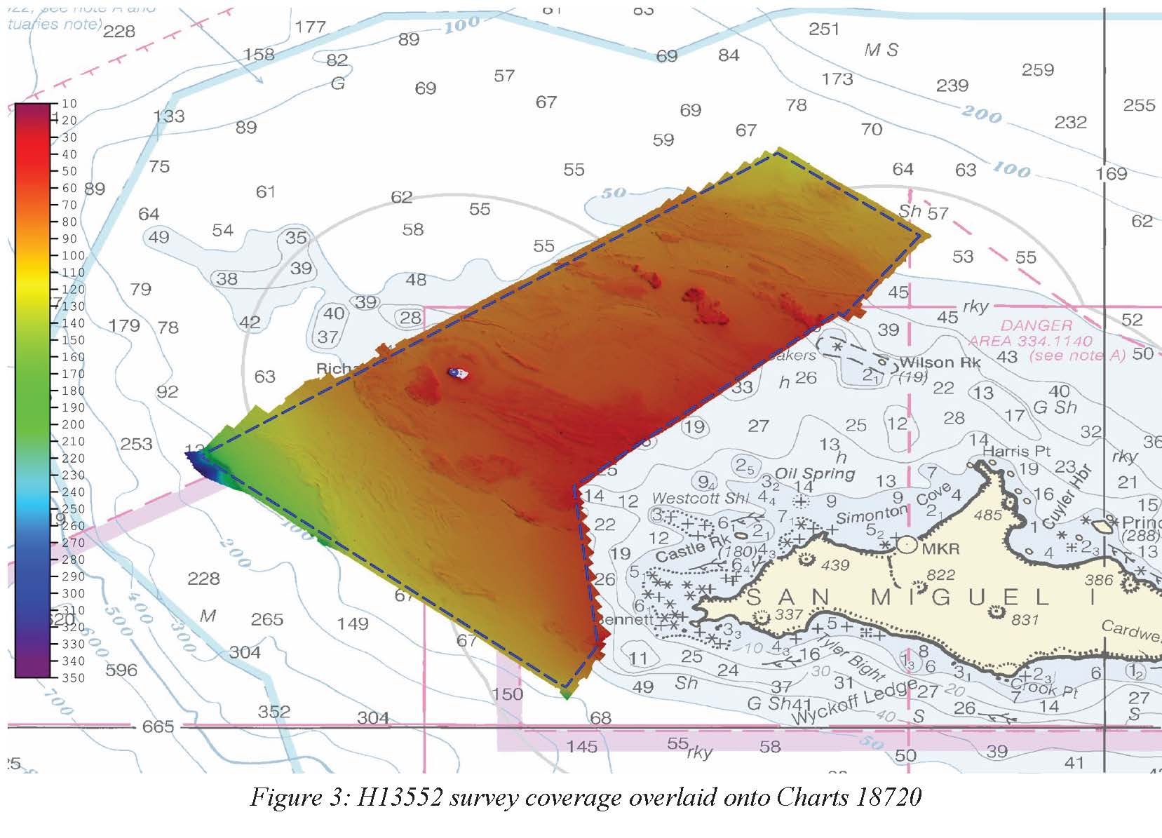
Federal
H13552: NOS Hydrographic Survey , 2021-10-07
National Oceanic and Atmospheric Administration, Department of Commerce —
The National Oceanic and Atmospheric Administration (NOAA) has the statutory mandate to collect hydrographic data in support of nautical chart compilation for safe... -
Federal
H11341A: NOS Hydrographic Survey , 2004-05-27
National Oceanic and Atmospheric Administration, Department of Commerce —
The National Oceanic and Atmospheric Administration (NOAA) has the statutory mandate to collect hydrographic data in support of nautical chart compilation for safe... -
Federal
H10701: NOS Hydrographic Survey , Southwest Alaska Peninsula. Alaska, 1996-08-03
National Oceanic and Atmospheric Administration, Department of Commerce —
The National Oceanic and Atmospheric Administration (NOAA) has the statutory mandate to collect hydrographic data in support of nautical chart compilation for safe... -
Federal
F00403: NOS Hydrographic Survey , Approaches to Galveston, Texas, 1994-07-27
National Oceanic and Atmospheric Administration, Department of Commerce —
The National Oceanic and Atmospheric Administration (NOAA) has the statutory mandate to collect hydrographic data in support of nautical chart compilation for safe... -
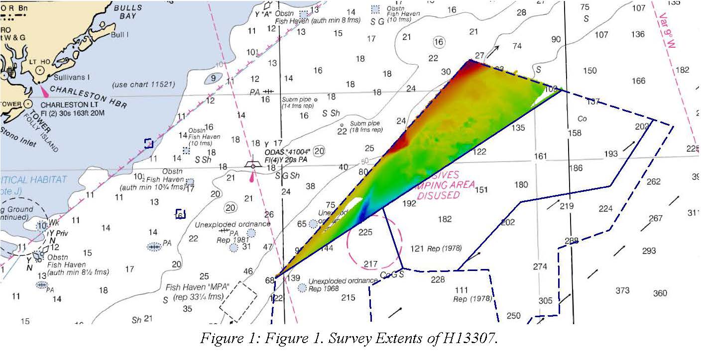
Federal
H13307: NOS Hydrographic Survey , 2019-08-30
National Oceanic and Atmospheric Administration, Department of Commerce —
The National Oceanic and Atmospheric Administration (NOAA) has the statutory mandate to collect hydrographic data in support of nautical chart compilation for safe...

Official websites use .gov
A
.gov website belongs to an official government
organization in the United States.
Secure .gov websites use HTTPS
A
lock (
) or https:// means you’ve safely connected to
the .gov website. Share sensitive information only on official,
secure websites.
.jpg)
.jpg)
.jpg)
.jpg)
.jpg)
.jpg)