
-
Federal
SWOT Level 2 Nadir Altimeter Operational Geophysical Data Record with Waveforms Version 1.0
National Aeronautics and Space Administration —
The SWOT Level 2 Nadir Altimeter Operational Geophysical Data Record (OGDR) with Waveforms Version 1.0 dataset produced by the Surface Water and Ocean Topography... -
Federal
TROPESS Chemical Reanalysis Ozone Spread 6-Hourly 3-dimensional Product V1 (TRPSCRO3S6H3D) at GES DISC
National Aeronautics and Space Administration —
The TROPESS Chemical Reanalysis O3 Spread 6-Hourly 3-dimensional Product contains the ozone ensemble spread, a measure of data assimilation analysis uncertainty. The... -
Federal
TRMM Precipitation Radar Rain Characteristics L2 1.5 hours V7 (TRMM_2A23) at GES DISC
National Aeronautics and Space Administration —
The new version of these data is in GPM-like format (consistent with the GPM Dual-frequency Radar data format), and can be found under the name GPM_2APR. The TRMM... -
Federal
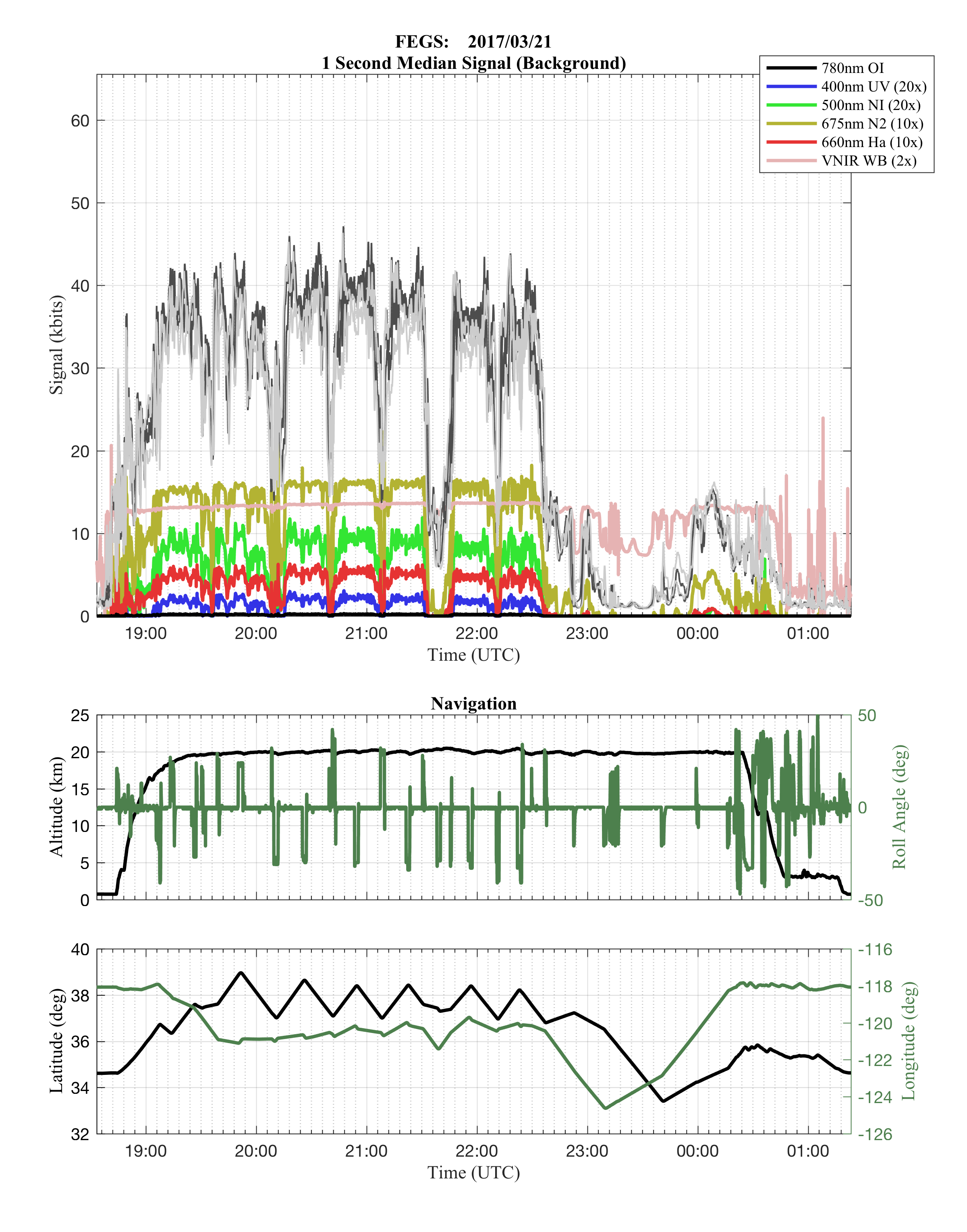
GOES-R PLT Fly's Eye GLM Simulator (FEGS) V1
National Aeronautics and Space Administration —
The GOES-R PLT Fly’s Eye GLM Simulator (FEGS) dataset consists of lightning flash, lightning pulse, and radiance data collected by the FEGS flown aboard a NASA ER-2... -
Federal
NOAA/WDS Paleoclimatology - Brown fire data from Archuleta Mesa Plot B35 - IMPD USACH016
National Oceanic and Atmospheric Administration, Department of Commerce —
This archived Paleoclimatology Study is available from the NOAA National Centers for Environmental Information (NCEI), under the World Data Service (WDS) for... -
Federal
NOAA/WDS Paleoclimatology - Brown fire data from Mica Mine - IMPD USMMF001
National Oceanic and Atmospheric Administration, Department of Commerce —
This archived Paleoclimatology Study is available from the NOAA National Centers for Environmental Information (NCEI), under the World Data Service (WDS) for... -
Federal
NOAA/WDS Paleoclimatology - Brown fire data from Black Hills Plot 201 - IMPD US201001
National Oceanic and Atmospheric Administration, Department of Commerce —
This archived Paleoclimatology Study is available from the NOAA National Centers for Environmental Information (NCEI), under the World Data Service (WDS) for... -
Federal
GPM DPR Ku-band Received Power L1B 1.5 hours 5 km V07 (GPM_PRL1KU) at GES DISC
National Aeronautics and Space Administration —
Version 07 is the current version of the data set. Older versions are no longer available and have been superseded by Version 07. This product contains the calibrated... -
Federal
SAMS/Nimbus-7 Level 1 Radiance Data from CD-ROM V001 (SAMSN7L1RAD_CDROM) at GES DISC
National Aeronautics and Space Administration —
SAMSN7L1RAD_CDROM is the gridded Nimbus-7 Stratospheric and Mesospheric Sounder (SAMS) Level 1 Radiance Data Product. The radiances were selected to derive gas... -
Federal
TROPICS06 L1B Orbital Geolocated Native-Resolution Brightness Temperatures V1.0
National Aeronautics and Space Administration —
The "Time-Resolved Observations of Precipitation structure and storm Intensity with a Constellation of Smallsats" (TROPICS) mission has a goal of providing nearly... -
Federal
SAMS/Nimbus-7 Level 1 Radiance Data V001 (SAMSN7L1RAT) at GES DISC
National Aeronautics and Space Administration —
SAMSN7L1RAT is the gridded Nimbus-7 Stratospheric and Mesospheric Sounder (SAMS) Level 1 Radiance Data Product. The radiances were selected to derive gas... -
Federal
GPM GROUND VALIDATION NEXRAD LEVEL II KDMX IFLOODS V1
National Aeronautics and Space Administration —
The GPM Ground Validation Next Generation Weather Radar (NEXRAD) Level II IFloodS datasets were collected from four sites (see Table 1) from March 29, 2013 to June... -
Federal
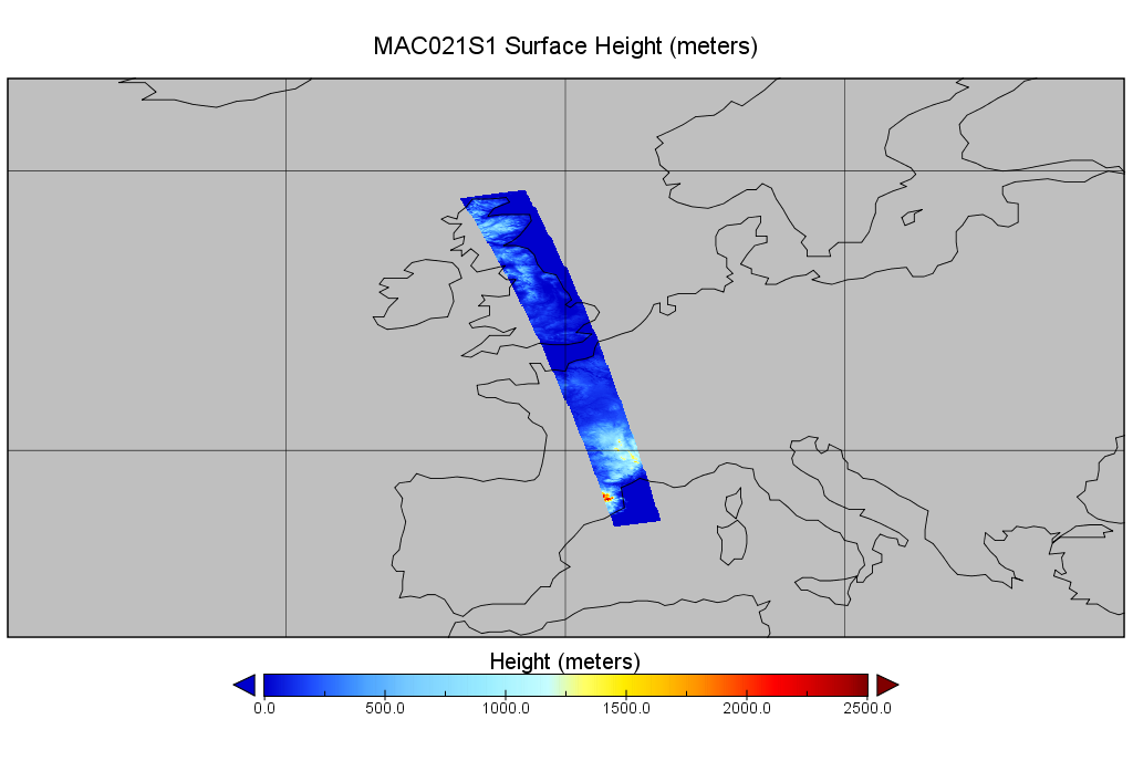
MODIS/Aqua Calibrated Radiances 1km 5-Min 1B Wide Swath Subset along CloudSat V002 (MAC021S1) at GES DISC NGDA
National Aeronautics and Space Administration —
This is the wide-swath MODIS/Aqua subset along CloudSat field of view track. The goal of the wide-swath subset is to select and return MODIS data that are within... -
Federal
MODIS/Aqua CLD Mask Spect. Results 250m and 1km 5-Min L2 Wide Swath Subset along CloudSat V002 (MAC35S1) at GES DISC NGDA
National Aeronautics and Space Administration —
This is the wide-swath MODIS/Aqua subset along CloudSat field of view track. The goal of the wide-swath subset is to select and return MODIS data that are within... -
Federal
NOAA/WDS Paleoclimatology - Heyerdahl fire data from Lava Beds National Monument, Hippo Butte - IMPD USLBH001
National Oceanic and Atmospheric Administration, Department of Commerce —
This archived Paleoclimatology Study is available from the NOAA National Centers for Environmental Information (NCEI), under the World Data Service (WDS) for... -
Federal
NOAA/WDS Paleoclimatology - Heyerdahl fire data from Lava Beds National Monument, Bearpaw Butte - IMPD USLBB001
National Oceanic and Atmospheric Administration, Department of Commerce —
This archived Paleoclimatology Study is available from the NOAA National Centers for Environmental Information (NCEI), under the World Data Service (WDS) for... -
Federal
NOAA/WDS Paleoclimatology - Brown fire data from Upper Pine Mid-Basin - IMPD USUPM001
National Oceanic and Atmospheric Administration, Department of Commerce —
This archived Paleoclimatology Study is available from the NOAA National Centers for Environmental Information (NCEI), under the World Data Service (WDS) for... -
Federal
NOAA/WDS Paleoclimatology - Mundo fire data from RÃo Lácteo, Patagonia - IMPD ARLAC001
National Oceanic and Atmospheric Administration, Department of Commerce —
This archived Paleoclimatology Study is available from the NOAA National Centers for Environmental Information (NCEI), under the World Data Service (WDS) for... -
Federal
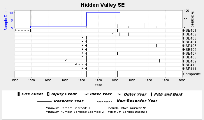
NOAA/WDS Paleoclimatology - Sherriff fire data from Hidden Valley SE - IMPD USHV1001
National Oceanic and Atmospheric Administration, Department of Commerce —
This archived Paleoclimatology Study is available from the NOAA National Centers for Environmental Information (NCEI), under the World Data Service (WDS) for... -
Federal
NOAA/WDS Paleoclimatology - Brown fire data from Moon Campground - IMPD USMON001
National Oceanic and Atmospheric Administration, Department of Commerce —
This archived Paleoclimatology Study is available from the NOAA National Centers for Environmental Information (NCEI), under the World Data Service (WDS) for...

Official websites use .gov
A
.gov website belongs to an official government
organization in the United States.
Secure .gov websites use HTTPS
A
lock (
) or https:// means you’ve safely connected to
the .gov website. Share sensitive information only on official,
secure websites.