
-
Federal
Public School Characteristics - Current recent views
Department of Education —
The National Center for Education Statistics' (NCES) Education Demographic and Geographic Estimate (EDGE) program develops annually updated point locations (latitude... -
Federal
School Neighborhood Poverty Estimates, 2020-21 recent views
Department of Education —
The 2020-2021 School Neighborhood Poverty Estimates are based on school locations from the 2020-2021 Common Core of Data (CCD) school file and income data from... -
Federal
School District Characteristics - Current recent views
Department of Education —
The National Center for Education Statistics’ (NCES) Education Demographic and Geographic Estimate (EDGE) program develops annually updated school district boundary... -
Federal
NACP North American Forest Dynamics Project: Forest Disturbance and Regrowth Data recent views
National Aeronautics and Space Administration —
This data set provides the results of time-series analyses of Landsat imagery for 55 selected forested sites across the conterminous U.S.A. The output is a pair of... -
Federal
Sea turtle population study in the coastal waters of North Carolina from 1988-06-07 to 2015-09-22 (NCEI Accession 0162846) recent views
National Oceanic and Atmospheric Administration, Department of Commerce —
This data set contains sea turtle length and weight measurements, sex ratios, species composition, capture and release locations, tagging information, and information... -
Federal
School Neighborhood Poverty Estimates - Current recent views
Department of Education —
The 2020-2021 School Neighborhood Poverty Estimates are based on school locations from the 2020-2021 Common Core of Data (CCD) school file and income data from... -
Federal
ASTER Digital Elevation Model V003 NGDA recent views
National Aeronautics and Space Administration —
The ASTER Digital Elevation Model (AST14DEM) product is generated (https://lpdaac.usgs.gov/documents/996/ASTER_Earthdata_Search_Order_Instructions.pdf) using bands 3N... -
Federal
LiDAR Surveys over Selected Forest Research Sites, Brazilian Amazon, 2008-2018 recent views
National Aeronautics and Space Administration —
This dataset provides the complete catalog of point cloud data collected during LiDAR surveys over selected forest research sites across the Amazon rainforest in... -
Federal
Public School Characteristics - Current recent views
Department of Education —
The National Center for Education Statistics' (NCES) Education Demographic and Geographic Estimate (EDGE) program develops annually updated point locations (latitude... -
Federal
BigFoot Field Data for North American Sites, 1999-2003 recent views
National Aeronautics and Space Administration —
The BigFoot project gathered field data for selected EOS Land Validation Sites in North America from 1999 to 2003. Data collected and derived for varying intervals at... -
Federal
Offshore Oil and Gas Platforms recent views
National Oceanic and Atmospheric Administration, Department of Commerce —
These data show the location for oil and gas platforms located in the state and federal waters of the United States. Generally, this data set does not show platforms... -
Federal
OCO-2 Level 2 bias-corrected XCO2 and other select fields from the full-physics retrieval aggregated as daily files, Retrospective processing V11.1r (OCO2_L2_Lite_FP) at GES DISC recent views
National Aeronautics and Space Administration —
Version 11r is the current version of the data set. Older versions will no longer be available and are superseded by Version 11r. The OCO-2 Lite files contain bias-... -
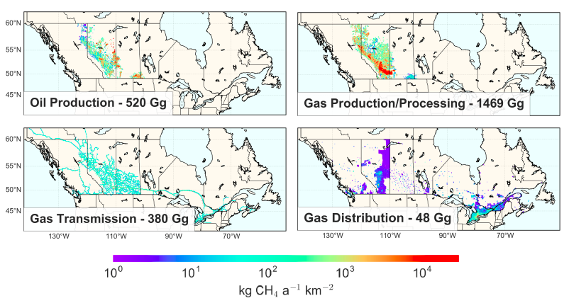
Federal
Methane (CH4) Flux for Canadian Oil/Gas Systems L4 V1 (CMS_CH4_FLX_CA) at GES DISC recent views
National Aeronautics and Space Administration —
This data set (CMS_CH4_FLX_CA) contains the yearly average methane (CH4) flux for Canada's oil and gas systems based on a bottom up calculation of oil/gas emissions... -
Federal
NOAA ENC Direct to GIS recent views
National Oceanic and Atmospheric Administration, Department of Commerce —
NOAA's Electronic Navigational Charts (NOAA ENCs) have been developed to support the marine transportation infrastructure and coastal management. The NOAA ENCs are in... -
Federal
Meteorological and oceanographic data collected from the National Data Buoy Center Coastal-Marine Automated Network (C-MAN) and moored (weather) buoys recent views
National Oceanic and Atmospheric Administration, Department of Commerce —
The National Data Buoy Center (NDBC) established the Coastal-Marine Automated Network (C-MAN) for the National Weather Service in the early 1980's. NDBC has installed... -
Federal
Polar Radiant Energy in the Far InfraRed Experiment (PREFIRE) Satellite 1 telemetry R01 recent views
National Aeronautics and Space Administration —
Polar Radiant Energy in the Far InfraRed Experiment (PREFIRE) Satellite 1 Telemetry (PREFIRE_SAT1_0-BUS-TLM) contains positioning and pointing information for one of... -
Federal
2022 Cartographic Boundary File (KML), Current County Subdivision for Michigan, 1:500,000 recent views
U.S. Census Bureau, Department of Commerce —
The 2022 cartographic boundary KMLs are simplified representations of selected geographic areas from the U.S. Census Bureau's Master Address File / Topologically... -
Federal
2024 NOAA NGS Emergency Response Imagery: Hurricane Milton recent views
National Oceanic and Atmospheric Administration, Department of Commerce —
Aerial imagery was acquired following Hurricane Milton. The aerial photography missions were conducted by the NOAA Remote Sensing Division. The images were acquired... -
Federal
Public School Characteristics 2018-19 recent views
Department of Education —
The National Center for Education Statistics' (NCES) Education Demographic and Geographic Estimate (EDGE) program develops annually updated point locations (latitude... -
Federal
MERRA-2 statD_2d_slv_Nx: 2d,Daily,Aggregated Statistics,Single-Level,Assimilation,Single-Level Diagnostics 0.625 x 0.5 degree V5.12.4 (M2SDNXSLV) at GES DISC recent views
National Aeronautics and Space Administration —
M2SDNXSLV (or statD_2d_slv_Nx) is a 2-dimensional daily data collection in Modern-Era Retrospective analysis for Research and Applications version 2 (MERRA-2). This...

Official websites use .gov
A
.gov website belongs to an official government
organization in the United States.
Secure .gov websites use HTTPS
A
lock (
) or https:// means you’ve safely connected to
the .gov website. Share sensitive information only on official,
secure websites.