
-
Federal
National Agriculture Imagery Program (NAIP)
National Aeronautics and Space Administration —
The National Agriculture Imagery Program (NAIP) acquires aerial imagery during the agricultural growing seasons in the continental U.S. A primary goal of the NAIP... -
Federal
U.S. Monthly Climate Normals (1981-2010)
National Oceanic and Atmospheric Administration, Department of Commerce —
The U.S. Monthly Climate Normals for 1981 to 2010 are 30-year averages of meteorological parameters for thousands of U.S. stations located across the 50 states, as... -
Federal
US Forest Atlas FIA Modeled Abundance, Forest-type Groups, Harvest and Carbon (Rest Services Directory)
Department of Agriculture —
FIA Modeled Abundance:�This dataset portrays the live tree mean basal area (square feet per acre) of the species across the contiguous United States. The underlying... -
Federal
U.S. Climate Normals 2020: U.S. Annual/Seasonal Climate Normals (1991-2020)
National Oceanic and Atmospheric Administration, Department of Commerce —
The U.S. Annual/Seasonal Climate Normals for 1991 to 2020 are 30-year averages of meteorological parameters that provide users the information needed to understand... -
State
Soils Hydric Rating
State of Connecticut —
This rating indicates the percentage of map units that meets the criteria for hydric soils. Map units are composed of one or more map unit components or soil types,... -
Federal
Climate Change Pressures Growing Degree Days (Map Service)
Department of Agriculture —
Evaluating multiple signals of climate change across the conterminous United States during three 30-year periods (2010�2039, 2040�2069, 2070�2099) during this century... -
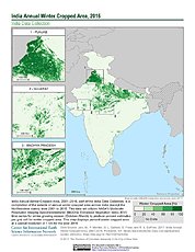
Federal
India Annual Winter Cropped Area, 2001-2016 NGDA
National Aeronautics and Space Administration —
The India Annual Winter Cropped Area, 2001 - 2016 consists of annual winter cropped areas for most of India (except the Northeastern states) from 2000-2001 to... -
Federal
Number of Frost-Free Days (Map Service)
Department of Agriculture —
Date of freeze for historical (1985-2005) and future (2071-2090, RCP 8.5) time periods, and absolute change between them, based on analysis of MACAv2METDATA. Download... -
Federal
MDDNR, Station Dares Beach
National Oceanic and Atmospheric Administration, Department of Commerce —
At continuous monitoring sites throughout Maryland, water quality is monitored at shallow water sites located in Chesapeake Bay, Chesapeake Bay tributaries and... -
Federal
MDDNR, Station Public Landing
National Oceanic and Atmospheric Administration, Department of Commerce —
At continuous monitoring sites throughout Maryland, water quality is monitored at shallow water sites located in Chesapeake Bay, Chesapeake Bay tributaries and... -
Federal
Alaska AVHRR Twice-Monthly Composites
National Aeronautics and Space Administration —
The goal of the Alaska Advanced Very High Resolution Radiometer (AVHRR) project is to compile a time series data set of calibrated, georegistered daily observations... -
Federal
Terrestrial Condition Assessment (TCA) Ozone - Acute
Department of Agriculture —
Direct Download (Raster Data Gateway)Objective: Assess impacts to vegetation from acute exposure to ozone (O3) during the growing season (April to September).Data:... -
Federal
MDDNR, Station Budds Landing
National Oceanic and Atmospheric Administration, Department of Commerce —
At continuous monitoring sites throughout Maryland, water quality is monitored at shallow water sites located in Chesapeake Bay, Chesapeake Bay tributaries and... -
Federal
MDDNR, Station Gooses - Surface
National Oceanic and Atmospheric Administration, Department of Commerce —
At continuous monitoring sites throughout Maryland, water quality is monitored at shallow water sites located in Chesapeake Bay, Chesapeake Bay tributaries and... -
Federal
MDDNR, Station Little Monie Creek
National Oceanic and Atmospheric Administration, Department of Commerce —
At continuous monitoring sites throughout Maryland, water quality is monitored at shallow water sites located in Chesapeake Bay, Chesapeake Bay tributaries and... -
Federal
MDDNR, Station Otter Point Creek
National Oceanic and Atmospheric Administration, Department of Commerce —
At continuous monitoring sites throughout Maryland, water quality is monitored at shallow water sites located in Chesapeake Bay, Chesapeake Bay tributaries and... -
Federal
MDDNR, Station Sandy Point - South Beach
National Oceanic and Atmospheric Administration, Department of Commerce —
At continuous monitoring sites throughout Maryland, water quality is monitored at shallow water sites located in Chesapeake Bay, Chesapeake Bay tributaries and... -
Federal
MDDNR, Station Iron Pot Landing
National Oceanic and Atmospheric Administration, Department of Commerce —
At continuous monitoring sites throughout Maryland, water quality is monitored at shallow water sites located in Chesapeake Bay, Chesapeake Bay tributaries and... -
Federal
MDDNR, Station Aquarium East - Bottom
National Oceanic and Atmospheric Administration, Department of Commerce —
At continuous monitoring sites throughout Maryland, water quality is monitored at shallow water sites located in Chesapeake Bay, Chesapeake Bay tributaries and... -
Federal
MDDNR, Station Tolchester
National Oceanic and Atmospheric Administration, Department of Commerce —
At continuous monitoring sites throughout Maryland, water quality is monitored at shallow water sites located in Chesapeake Bay, Chesapeake Bay tributaries and...

Official websites use .gov
A
.gov website belongs to an official government
organization in the United States.
Secure .gov websites use HTTPS
A
lock (
) or https:// means you’ve safely connected to
the .gov website. Share sensitive information only on official,
secure websites.