

14 datasets found for "Ice"
-
Federal
Global Landslide Hazard Distribution
National Aeronautics and Space Administration —
The Global Landslide Hazard Distribution is a 2.5 minute grid of global landslide and snow avalanche hazards based upon work of the Norwegian Geotechnical Institute... -
Federal
Gridded Population of the World, Version 3 (GPWv3): Land and Geographic Unit Area Grids
National Aeronautics and Space Administration —
The Gridded Population of the World, Version 3 (GPWv3): Land and Geographic Unit Area Grids measure land areas in square kilometers and the mean Unit size... -
Federal
Global Multihazard Frequency and Distribution
National Aeronautics and Space Administration —
The Global Multihazard Frequency and Distribution is a 2.5 minute grid presenting a simple multihazard index based solely on summated single-hazard decile values. The... -
Federal
U.S. Climate Risk Projections by County, 2040-2049
National Aeronautics and Space Administration —
The U.S. Climate Risk Projections by County, 2040-2049 data set contains a projection for 2040-2049 risk for the entire contiguous U.S. at the county level with a... -
Federal
Global Multihazard Total Economic Loss Risk Deciles
National Aeronautics and Space Administration —
The Global Multihazard Total Economic Loss Risk Deciles is a 2.5 minute grid of global multihazard total economic loss risks. First, for each of the considered... -
Federal
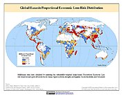
Global Multihazard Proportional Economic Loss Risk Deciles
National Aeronautics and Space Administration —
The Global Multihazard Proportional Economic Loss Risks is a 2.5 minute grid of a multihazard-based economic loss risk as a proportion of the economic productivity of... -
Federal
Gridded Population of the World, Version 4 (GPWv4): Data Quality Indicators, Revision 11
National Aeronautics and Space Administration —
The Gridded Population of the World, Version 4 (GPWv4): Data Quality Indicators, Revision 11 consists of three data layers created to provide context for the... -
Federal
Global Landslide Mortality Risks and Distribution
National Aeronautics and Space Administration —
The Global Landslide Mortality Risks and Distribution is a 2.5 minute grid of global landslide mortality risks. Gridded Population of the World, Version 3 (GPWv3)... -
Federal
Global Landslide Proportional Economic Loss Risk Deciles
National Aeronautics and Space Administration —
The Global Landslide Proportional Economic Loss Risk Deciles is a 2.5 minute grid of landslide hazard economic loss as proportions of Gross Domestic Product (GDP) per... -
Federal
Global Rural-Urban Mapping Project, Version 1 (GRUMPv1): Land and Geographic Unit Area Grids
National Aeronautics and Space Administration —
The Global Rural-Urban Mapping Project, Version 1 (GRUMPv1): Land and Geographic Unit Area Grids measure land areas in square kilometers and the mean Unit size... -
Federal
Trends in Global Freshwater Availability from the Gravity Recovery and Climate Experiment (GRACE)
National Aeronautics and Space Administration —
The Trends in Global Freshwater Availability from the Gravity Recovery and Climate Experiment (GRACE), 2002-2016, is a global gridded data set at a spatial resolution... -
Federal
Gridded Population of the World, Version 4 (GPWv4): Land and Water Area, Revision 11
National Aeronautics and Space Administration —
The Gridded Population of the World, Version 4 (GPWv4): Land and Water Area, Revision 11 consists of two rasters that measure surface areas of land and water in... -
Federal
Global Multihazard Mortality Risks and Distribution
National Aeronautics and Space Administration —
The Global Multihazard Mortality Risks and Distribution is a 2.5 minute grid identifying and characterizing the nature of multihazard risk at the global scale. For...
14 datasets found for "Ice"