
-
Federal
Fire Intensity and Burn Severity Metrics for Circumpolar Boreal Forests, 2001-2013 NGDA recent views
National Aeronautics and Space Administration —
This data set provides products characterizing immediate and longer-term ecosystem changes from fires in the circumpolar boreal forests of Northern Eurasia and North... -
Federal
ISLSCP II Ecosystem Rooting Depths NGDA recent views
National Aeronautics and Space Administration —
The goal of this study was to predict the global distribution of plant rooting depths based on data about global aboveground vegetation structure and climate.... -
Federal
Net Radiation and Albedo from MODIS for Xingu River Basin, Brazil, 2000-2012 NGDA recent views
National Aeronautics and Space Administration —
This dataset provides daily average land surface net radiation (Rnet) as an 8-day time series at approximately 0.5 km resolution for the upper Xingu River Basin in... -
Federal
ISLSCP II MODIS (Collection 4) Albedo, 2002 NGDA recent views
National Aeronautics and Space Administration —
This International Satellite Land Surface Climatology Project (ISLSCP II) MODerate resolution Image Spectroradiometer (MODIS) dataset, ISLSCP II MODIS (Collection 4)... -
Federal
ISLSCP II FASIR-adjusted NDVI, 1982-1998 NGDA recent views
National Aeronautics and Space Administration —
The Fourier-Adjusted, Sensor and Solar zenith angle corrected, Interpolated, Reconstructed (FASIR) adjusted Normalized Difference Vegetation Index (NDVI) data sets... -
Federal
ISLSCP II IGBP DISCover and SiB Land Cover, 1992-1993 NGDA recent views
National Aeronautics and Space Administration —
This data set describes the geographic distributions of 17 classes of land cover based on the International Geosphere-Biosphere DISCover land cover legend (Loveland... -
Federal
ISLSCP II GIMMS Monthly NDVI, 1981-2002 NGDA recent views
National Aeronautics and Space Administration —
The Global Inventory Modelling and Mapping Studies (GIMMS) Normalized Difference Vegetation Index (NDVI) data sets were generated to provide a 22-year satellite... -
Federal
ISLSCP II MODIS (Collection 4) IGBP Land Cover, 2000-2001 NGDA recent views
National Aeronautics and Space Administration —
This data set, ISLSCP II MODIS (Collection 4) IGBP Land Cover, 2000-2001, contains global land cover classifications (dominant type, classification confidence and... -
Federal
ISLSCP II Monthly Snow-Free Albedo, 1982-1998, and Background Soil Reflectance NGDA recent views
National Aeronautics and Space Administration —
This data set contains monthly average snow-free surface shortwave albedo calculated for the period 1982-1998 and estimates of background soil/litter reflectances in... -
Federal
MODIS-derived Vegetation and Albedo Parameters for Agroecosystem-Climate Modeling NGDA recent views
National Aeronautics and Space Administration —
This dataset provides MODIS-derived leaf area index (LAI), stem area index (SAI), vegetation area fraction, dominant landcover category, and albedo parameters for the... -
Federal
ISLSCP II C4 Vegetation Percentage NGDA recent views
National Aeronautics and Space Administration —
The photosynthetic composition (C3 or C4) of vegetation on the land surface is essential for accurate simulations of biosphere-atmosphere exchanges of carbon, water,... -
Federal
MODIS-based GPP, PAR, fC4, and SANIRv estimates from SLOPE for CONUS, 2000-2019 NGDA recent views
National Aeronautics and Space Administration —
This dataset contains estimated gross primary productivity (GPP), photosynthetically active radiation (PAR), soil adjusted near infrared reflectance of vegetation... -
Federal
SAFARI 2000 MODIS L3 Albedo and Land Cover Data, Southern Africa, Dry Season 2000 NGDA recent views
National Aeronautics and Space Administration —
The Filled Land Surface Albedo Product for Southern Africa, which is generated from MOD43B3 Product (the official Terra/MODIS-derived Land Surface Albedo -... -
Federal
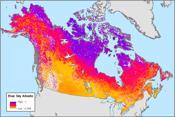
ABoVE: MODIS-Derived Daily Mean Blue Sky Albedo for Northern North America, 2000-2017 NGDA recent views
National Aeronautics and Space Administration —
This dataset contains MODIS-derived daily mean shortwave blue sky albedo for northern North America (i.e., Canada and Alaska) and a set of quality control flags for... -
Federal
Global MODIS and FLUXNET-derived Daily Gross Primary Production, V2 NGDA recent views
National Aeronautics and Space Administration —
This dataset provides global gridded daily estimates of gross primary production (GPP) and uncertainties at 0.05-degree resolution for the period 2000-03-01 to the... -
Federal
ISLSCP II AVHRR Albedo and BRDF, 1995 NGDA recent views
National Aeronautics and Space Administration —
This Albedo and BRDF (Bidirectional Reflectance Distribution Function) data set contains three files containing BRDF parameters, white- sky albedo and black-sky... -
Federal
ISLSCP II Snow-Free, Spatially Complete, 16 Day Albedo, 2002 NGDA recent views
National Aeronautics and Space Administration —
This data set, ISLSCP II Snow-Free, Spatially Complete, 16 Day Albedo, 2002, contains 9 files for snow-free, spatially complete 16-day global black-sky albedos at... -
Federal
SAFARI 2000 MODIS Water and Heat Fluxes, Maun, Botswana, Dry Season 2001 NGDA recent views
National Aeronautics and Space Administration —
A physically-based model, Energy: Surface Towards Atmosphere (ESTA), was used to model and map the energy and water balances of a heterogeneous land surface in a... -
Federal
ISLSCP II Historical Croplands Cover, 1700-1992 NGDA recent views
National Aeronautics and Space Administration —
The Historical Croplands Cover data set was developed to understand the consequences of historical changes in land use and land cover for ecosystem goods and... -
Federal
ISLSCP II Leaf Area Index (LAI) from Field Measurements, 1932-2000 NGDA recent views
National Aeronautics and Space Administration —
Leaf Area Index (LAI) data from the scientific literature, covering the period from 1932-2000, have been compiled at the Oak Ridge National Laboratory (ORNL)...

Official websites use .gov
A
.gov website belongs to an official government
organization in the United States.
Secure .gov websites use HTTPS
A
lock (
) or https:// means you’ve safely connected to
the .gov website. Share sensitive information only on official,
secure websites.