

14 datasets found for "National Transportation Analysis Regions"
-
Federal
Tidal Wetland Soil Carbon Stocks for the Conterminous United States, 2006-2010 recent views
National Aeronautics and Space Administration —
This dataset provides modeled estimates of soil carbon stocks for tidal wetland areas of the Conterminous United States (CONUS) for the period 2006-2010. Wetland... -
Federal
NACP Regional: Original Observation Data and Biosphere and Inverse Model Outputs recent views
National Aeronautics and Space Administration —
This data set contains the originally-submitted observation measurement data, terrestrial biosphere model output data, and inverse model simulations that various... -
Federal
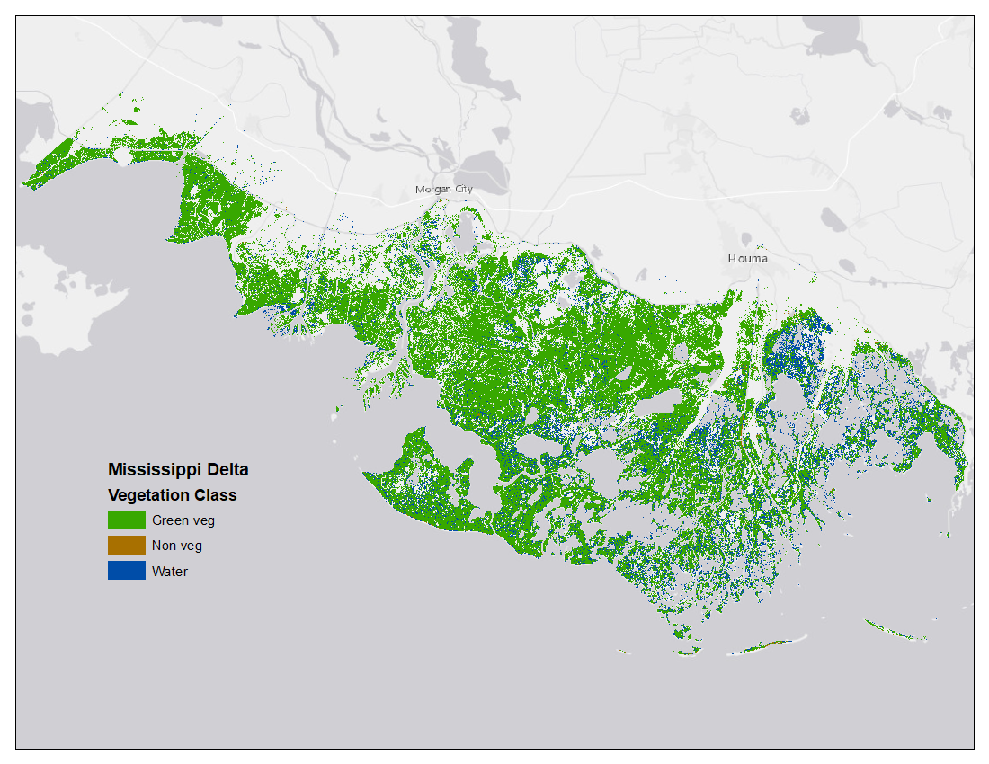
Vegetation and Open Water High-Resolution Maps for Selected US Tidal Marshes, 2015 recent views
National Aeronautics and Space Administration —
This dataset provides maps of tidal marsh green vegetation, non-vegetation, and open water for six estuarine regions of the conterminous United States: Cape Cod, MA;... -
Federal
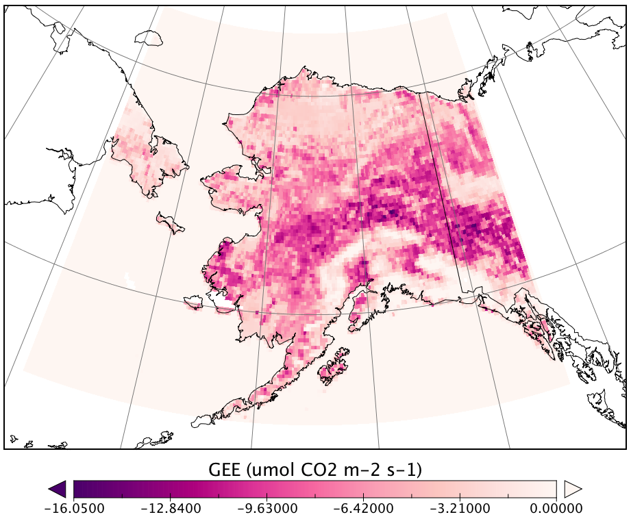
CARVE Modeled Gross Ecosystem CO2 Exchange and Respiration, Alaska, 2012-2014 NGDA recent views
National Aeronautics and Space Administration —
This data set provides 3-hourly estimates of gross ecosystem CO2 exchange (GEE) and respiration (autotrophic and heterotrophic) for the state of Alaska from 2012 to... -
Federal
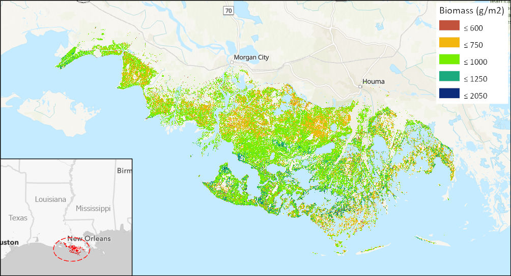
Aboveground Biomass High-Resolution Maps for Selected US Tidal Marshes, 2015 recent views
National Aeronautics and Space Administration —
This dataset provides maps of aboveground tidal marsh biomass (g/m2) at 30 m resolution for six estuarine regions of the conterminous United States: Cape Cod, MA;... -
Federal
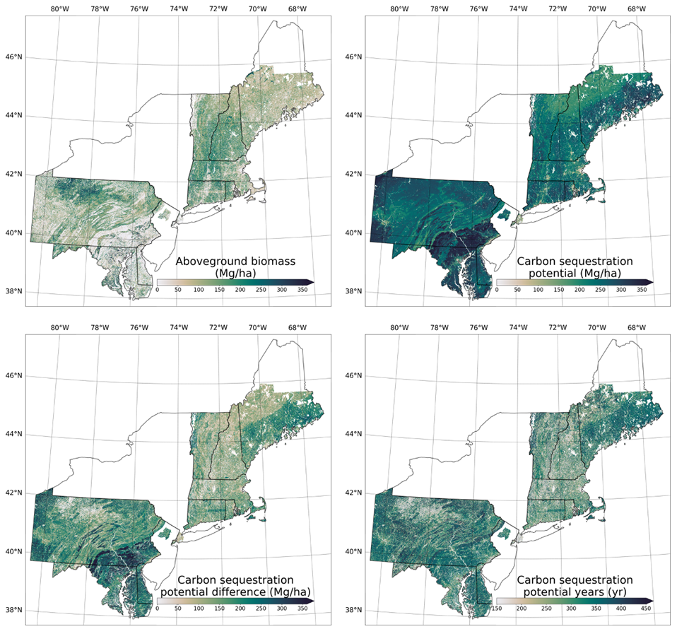
Forest Aboveground Biomass and Carbon Sequestration Potential, Northeastern USA recent views
National Aeronautics and Space Administration —
This dataset provides 90 m estimates of forest aboveground biomass (Mg/ha) for nominal 2011 and projections of carbon sequestration potential for 11 states in the... -
Federal
Forest Aboveground Biomass and Carbon Sequestration Potential for Maryland, USA. recent views
National Aeronautics and Space Administration —
This dataset provides 90-m resolution maps of estimated forest aboveground biomass (Mg/ha) for nominal year 2011 and projections of carbon sequestration potential for... -
Federal
SAFARI 2000 Aerosol Fatty Acid and Stable Isotope Data, Mongu, Dry Season 2000 recent views
National Aeronautics and Space Administration —
The Southern African Regional Science Initiative (SAFARI 2000) was conducted in part to investigate the impacts of the large-scale transport and deposition of... -
Federal
ISLSCP II Historical Croplands Cover, 1700-1992 NGDA recent views
National Aeronautics and Space Administration —
The Historical Croplands Cover data set was developed to understand the consequences of historical changes in land use and land cover for ecosystem goods and... -
Federal
Airborne Observations and Modeling Comparison of Global Inorganic Aerosol Acidity recent views
National Aeronautics and Space Administration —
This dataset provides observations collected during eleven airborne campaigns from 2006–2017 and associated input and output from nine widely used chemical transport... -
Federal
NACP LiDAR-based Biomass Estimates, Boreal Forest Biome, North America, 2005-2006 recent views
National Aeronautics and Space Administration —
This data set provides estimates of aboveground biomass (AGB) for defined land cover types within World Wildlife Fund (WWF) ecoregions across the boreal biome of... -
Federal
ATom: Dominant Role of Mineral Dust in Cirrus Cloud Formation recent views
National Aeronautics and Space Administration —
This dataset provides: (1) In situ dust aerosol concentration measurements over remote tropical Pacific and Atlantic Oceans by NOAA Particle Analysis by Laser Mass... -
Federal
LBA-ECO LC-02 Hot Pixel Fire Indicator Data for Tri-national MAP Region: 2003-2006 NGDA recent views
National Aeronautics and Space Administration —
This data set provides hot pixel data, as an indicator of fires, that were detected by various satellites in the tri-national MAP region (Madre de Dios-Peru, Acre-... -
Federal
Location and Permanency of Water Bodies in the African Sahel Region from 2003-2011 NGDA recent views
National Aeronautics and Space Administration —
This data set provides an estimate of the spatial and temporal extent of surface water at 250-m resolution over nine years (2003-2011) for the African Sahel region...
14 datasets found for "National Transportation Analysis Regions"