
-
Federal
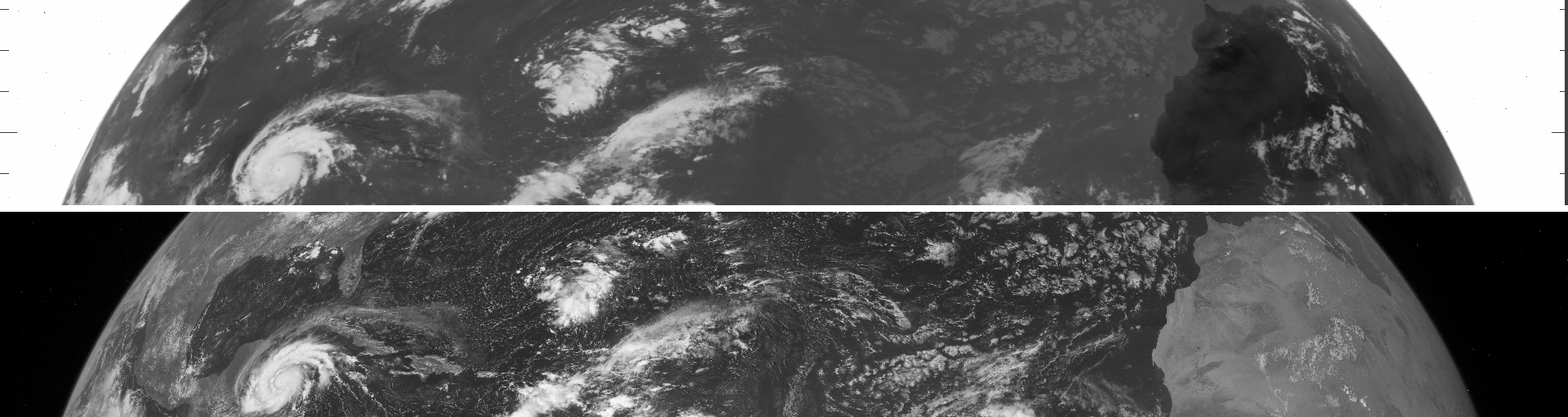
VISSR/SMS-2 Level 1 Atmospheric and Oceanographic Image Processing System (AOIPS) Data V001 (VISSRSMS2L1AOIPS) at GES DISC
National Aeronautics and Space Administration —
VISSRSMS2L1AOIPS is the Visible Infrared Spin-Scan Radiometer (VISSR) Level 1 Atmospheric and Oceanographic Image Processing System (AOIPS) data product from the... -
Federal
OMI/Aura Level 2 Sulphur Dioxide (SO2) Trace Gas Column Data 1-Orbit Subset and Collocated Swath along CloudSat V003 (OMSO2_CPR) at GES DISC
National Aeronautics and Space Administration —
This is a CloudSat-collocated subset of the original product OMSO2, for the purposes of the A-Train mission. The goal of the subset is to select and return OMI data... -
Federal
VISSR/SMS-1 Level 1 Atmospheric and Oceanographic Image Processing System (AOIPS) Data V001 (VISSRSMS1L1AOIPS) at GES DISC
National Aeronautics and Space Administration —
VISSRSMS1L1AOIPS is the Visible Infrared Spin-Scan Radiometer (VISSR) Level 1 Atmospheric and Oceanographic Image Processing System (AOIPS) data product from the... -
Federal
VISSR/SMS-1 Level 1 Experimenter History Data V001 (VISSRSMS1L1EHT) at GES DISC
National Aeronautics and Space Administration —
VISSRSMS1L1EHT is the Visible Infrared Spin-Scan Radiometer (VISSR) Level 1 Experimenter History Tape (EHT) data product from the first Synchronous Meteorological... -
Federal
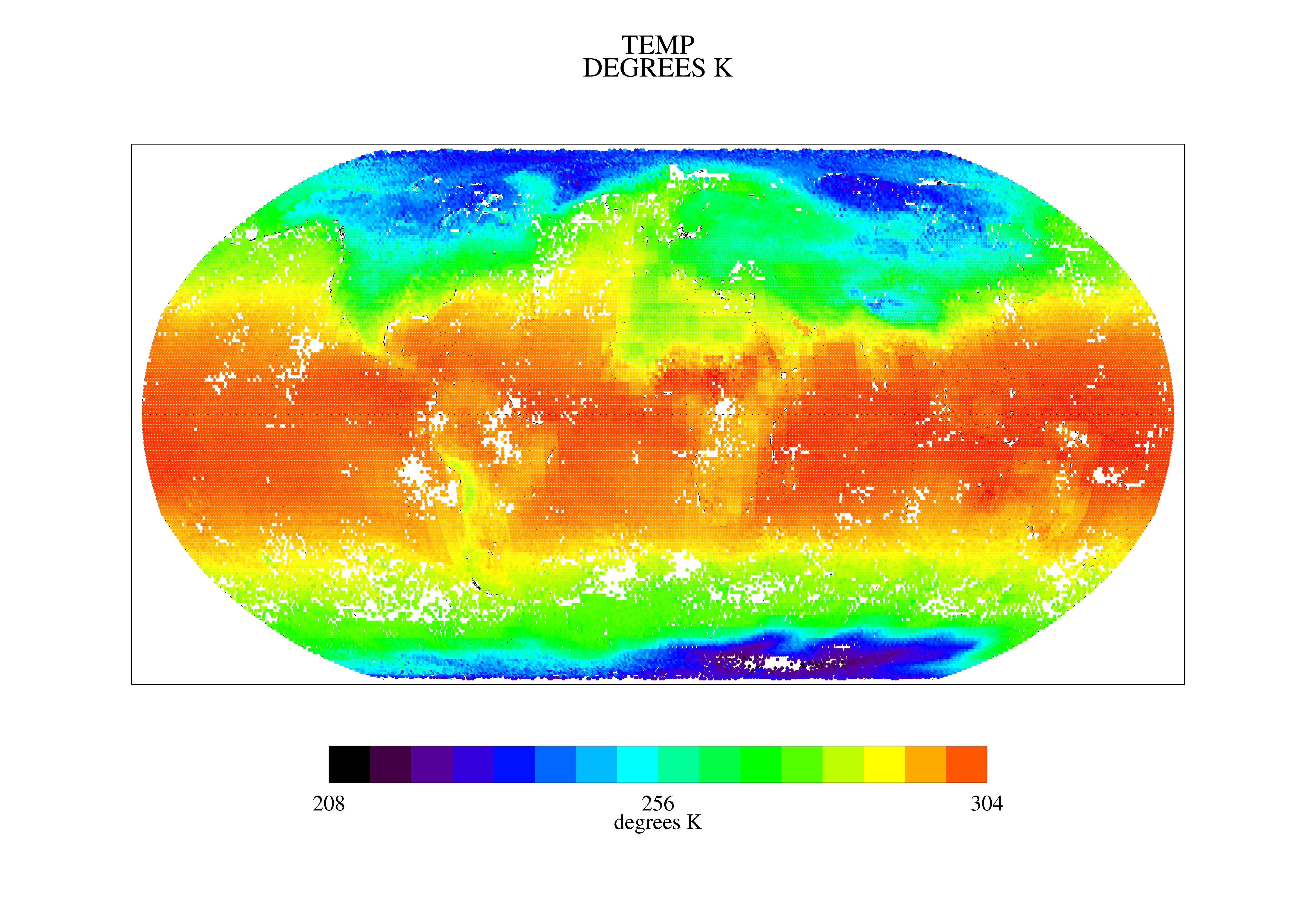
TOVS GLA DAILY GRIDS from NOAA-10 V01 (TOVSADNG) at GES DISC
National Aeronautics and Space Administration —
This dataset (TOVSADNG) contains the TIROS Operational Vertical Sounder (TOVS) level 3 geophysical parameters derived using data from NOAA-10 and the physical... -
Federal
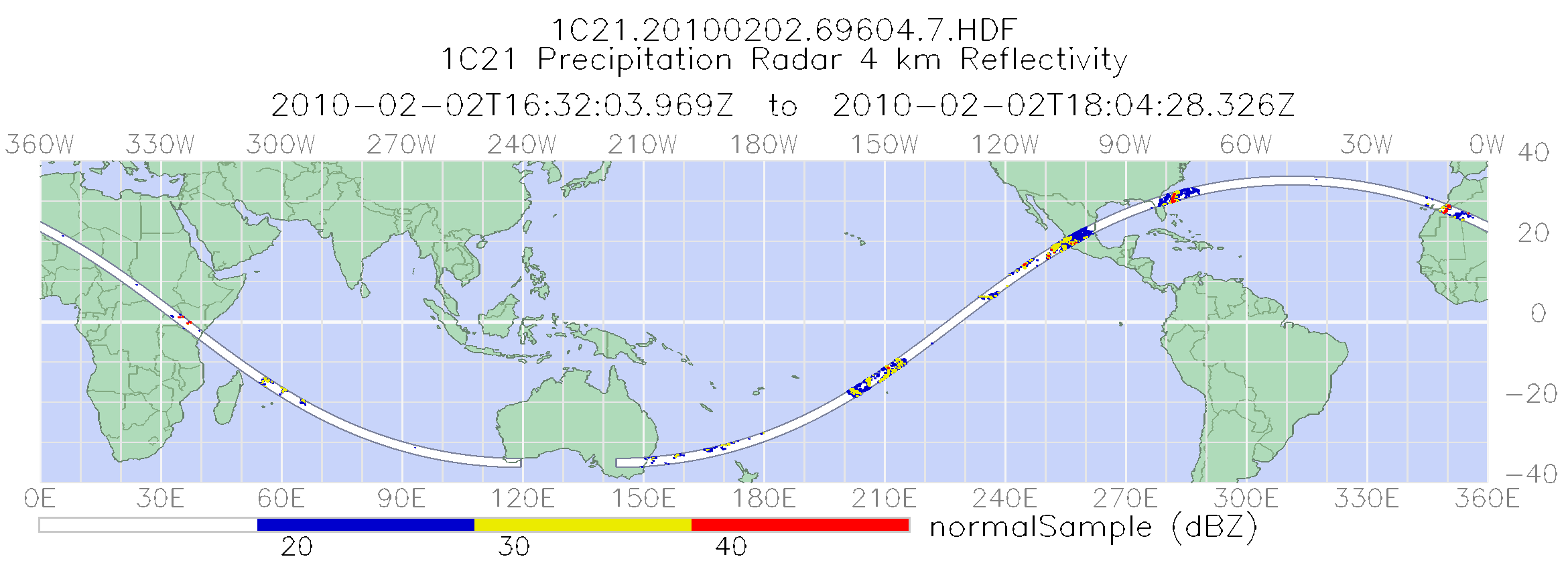
TRMM Precipitation Radar Power and Reflectivity L1C 1.5 hours V7 (TRMM_1C21) at GES DISC
National Aeronautics and Space Administration —
The TRMM Precipitation Radar (PR), the first of its kind in space, is an electronically scanning radar, operating at 13.8 GHz that measures the 3-D rainfall... -
Federal
TOVS GLA 5 DAY GRIDS from NOAA-11 V01 (TOVSA5NH) at GES DISC
National Aeronautics and Space Administration —
This dataset (TOVSA5NH) contains the TIROS Operational Vertical Sounder (TOVS) level 3 geophysical parameters derived using data from NOAA-11 and the physical... -
Federal
VISSR/SMS-2 Level 1 Experimenter History Data V001 (VISSRSMS2L1EHT) at GES DISC
National Aeronautics and Space Administration —
VISSRSMS2L1EHT is the Visible Infrared Spin-Scan Radiometer (VISSR) Level 1 Experimenter History Tape (EHT) data product from the second Synchronous Meteorological... -
Federal
TOVS GLA 5 DAY GRIDS from TIROSN V01 (TOVSA5TN ) at GES DISC
National Aeronautics and Space Administration —
This dataset (TOVSA5TN) contains the TIROS Operational Vertical Sounder (TOVS) level 3 geophysical parameters derived using data from TIROS-N and the physical... -
Federal
UARS Correlative UKMO Daily Gridded Stratospheric Assimilated Data V001 (UARZCUKM) at GES DISC
National Aeronautics and Space Administration —
The UARS Correlative assimilation data from the U.K. Meteorological Office (UKMO) consists of daily model runs at 12:00 GMT as a means of providing an independent... -
Federal
TOVS GLA MONTHLY GRIDS from NOAA-11 V01 (TOVSAMNH) at GES DISC
National Aeronautics and Space Administration —
This dataset (TOVSAMNH) contains the TIROS Operational Vertical Sounder (TOVS) level 3 geophysical parameters derived using data from NOAA-11 and the physical... -
Federal
THIR/Nimbus-7 Images of Daytime and Nighttime Brightness Temperature on 70 mm Film V001 (THIRN7IM) at GES DISC
National Aeronautics and Space Administration —
THIRN7IM is the Nimbus-7 Temperature-Humidity Infrared Radiometer (THIR) data product consisting of daily montages of brightness temperatures measured at 6.7 and 11.5... -
Federal
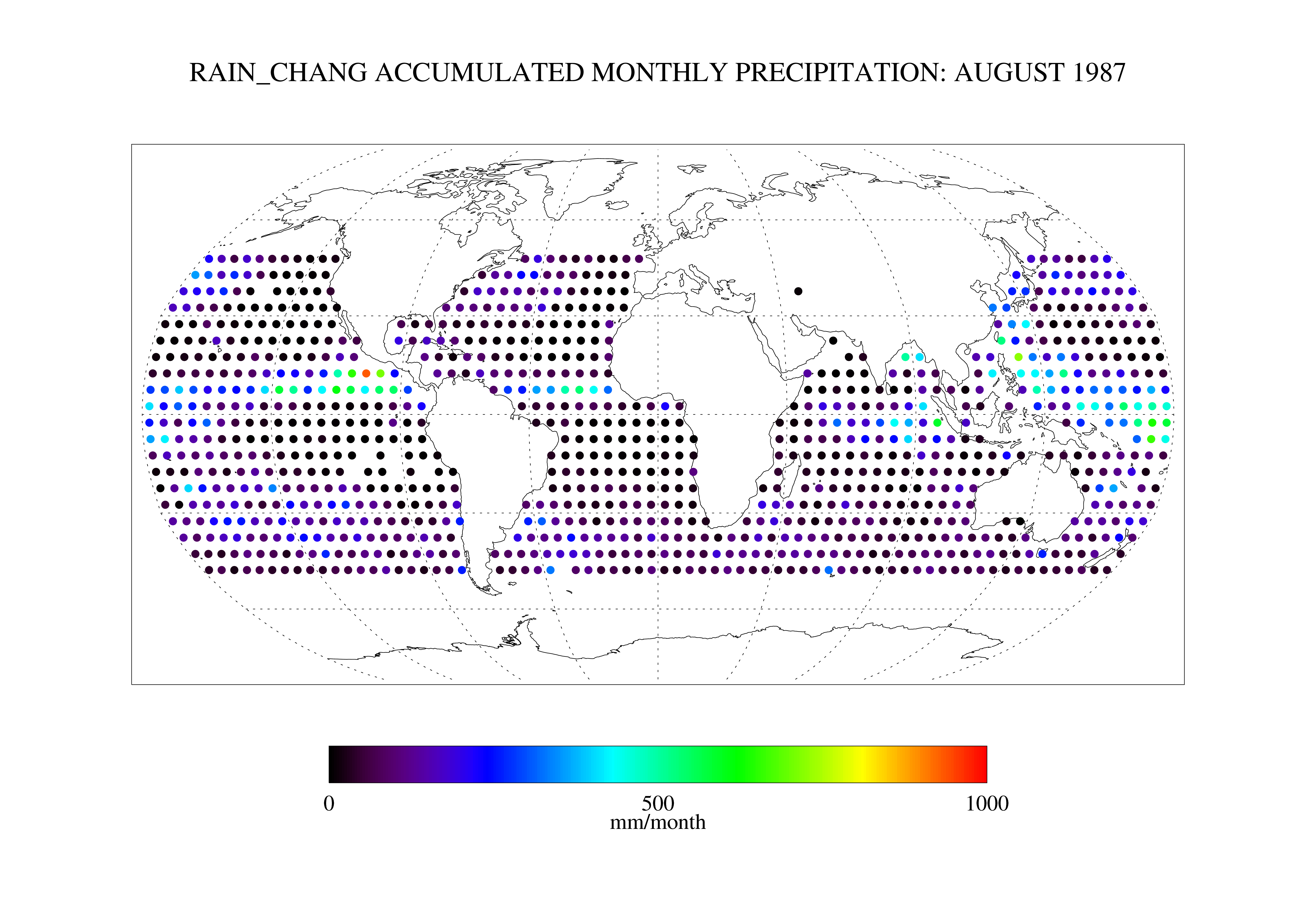
Chang SSM/I Derived Monthly Rain Indices 5 x 5 degree V2.3 (RAIN_CHANG) at GES DISC
National Aeronautics and Space Administration —
These data are transitioned to a state of permanent preservation. They are available upon request. More advanced datasets have been developed since. One recommended... -
Federal
TOVS GLA DAILY GRIDS from TIROSN V01 (TOVSADTN) at GES DISC
National Aeronautics and Space Administration —
This dataset (TOVSADTN) contains the TIROS Operational Vertical Sounder (TOVS) level 3 geophysical parameters derived using data from TIROS-N and the physical... -
Federal
TOVS GLA DAILY GRIDS from NOAA-12 V01 (TOVSADND) at GES DISC
National Aeronautics and Space Administration —
This dataset (TOVSADND) contains the TIROS Operational Vertical Sounder (TOVS) level 3 geophysical parameters derived using data from NOAA-12 and the physical... -
Federal
AIRS/Aqua L1B Near Real Time (NRT) Visible/Near Infrared (VIS/NIR) quality assurance subset V005 (AIRVBQAP_NRT) at GES DISC
National Aeronautics and Space Administration —
The AIRS Level 1B Near Real Time (NRT) product (AIRVBQAP_NRT_005) differs from the routine product (AIRVBQAP_005) in 2 ways to meet the three hour latency... -
Federal
TOVS GLA 5 DAY GRIDS from NOAA-10 V01 (TOVSA5NG) at GES DISC
National Aeronautics and Space Administration —
This dataset (TOVSA5NG) contains the TIROS Operational Vertical Sounder (TOVS) level 3 geophysical parameters derived using data from NOAA-10 and the physical... -
Federal
TOVS GLA MONTHLY GRIDS from NOAA-10 V01 (TOVSAMNG) at GES DISC
National Aeronautics and Space Administration —
This dataset (TOVSAMNG) contains the TIROS Operational Vertical Sounder (TOVS) level 3 geophysical parameters derived using data from NOAA-10 and the physical... -
Federal
TOVS GLA MONTHLY GRIDS from TIROSN V01 (TOVSAMTN) at GES DISC
National Aeronautics and Space Administration —
This dataset (TOVSAMTN) contains the TIROS Operational Vertical Sounder (TOVS) level 3 geophysical parameters derived using data from TIROSN and the physical... -
Federal
TOVS GLA 5 DAY GRIDS from NOAA-12 V01 (TOVSA5ND) at GES DISC
National Aeronautics and Space Administration —
This dataset (TOVSA5ND) contains the TIROS Operational Vertical Sounder (TOVS) level 3 geophysical parameters derived using data from NOAA-12 and the physical...

Official websites use .gov
A
.gov website belongs to an official government
organization in the United States.
Secure .gov websites use HTTPS
A
lock (
) or https:// means you’ve safely connected to
the .gov website. Share sensitive information only on official,
secure websites.