
-
Federal
OCO-2 Level 2 geolocated XCO2 retrievals results, physical model V11.2 (OCO2_L2_Standard) at GES DISC
National Aeronautics and Space Administration —
Version 11.2 is the current version of the data set. Older versions will no longer be available and are superseded by Version 11.2. The Orbiting Carbon Observatory is... -
Federal
Sentinel-5P TROPOMI Tropospheric NO2 1-Orbit L2 7km x 3.5km V1 (S5P_L2__NO2___) at GES DISC
National Aeronautics and Space Administration —
Starting from August 6th in 2019, Sentinel-5P TROPOMI along-track high spatial resolution (~5.5km at nadir) has been implemented. For data after August 6th of 2019,... -
Federal
Sentinel-5P TROPOMI Methane CH4 1-Orbit L2 7km x 7km V1 (S5P_L2__CH4___) at GES DISC
National Aeronautics and Space Administration —
Starting from August 6th in 2019, Sentinel-5P TROPOMI along-track high spatial resolution (~5.5km at nadir) has been implemented. For data after August 6th of 2019,... -
Federal
TRMM Ground Validation Calibrated QC Radar Reflectivity Full Volume Scan L1C 1 hour V7 (TRMM_1C51) at GES DISC
National Aeronautics and Space Administration —
The purpose of the 1C51 algorithm is to remove non-meteorological radar echoes that adversely affect the quality of higher level products, such as clutter associated... -
Federal
OCO-2 Level 0 spacecraft attitude data V11 (OCO2_Att) at GES DISC
National Aeronautics and Space Administration —
Version 11 is the current version of the data set. Older versions will no longer be available and are superseded by Version 11. The Orbiting Carbon Observatory is the... -
Federal
OCO-3 Level 2 CO2 prior based on CO2 monthly flask record, global meteorology, and age of air, Forward Processing V11 (OCO3_L2_CO2Prior) at GES DISC
National Aeronautics and Space Administration —
Version 11 is the current version of the data set. Older versions will no longer be available and are superseded by Version 11. The Orbiting Carbon Observatory -3... -
Federal
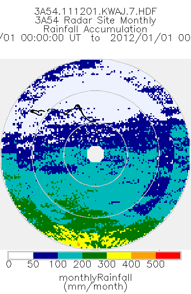
TRMM Ground Validation Radar Site Rain Type Totals Map L3 1 month 2 km V7 (TRMM_3A54) at GES DISC
National Aeronautics and Space Administration —
The 3A54 product, 'Site Rainfall Map', is a map of monthly surface rain totals derived from the instantaneous rain rate maps (2A53). The map is in Cartesian... -
Federal
OCO-3 Level 1B calibrated, geolocated calibration spectra, Retrospective Processing V11r (OCO3_L1B_Calibration) at GES DISC
National Aeronautics and Space Administration —
Version 11r is the current version of the data set. Older versions will no longer be available and are superseded by Version 11r. The Orbiting Carbon Observatory -3... -
Federal
TRMM Ground Validation Radar Site Rain Rate Map L2 1 hour 2 km V7 (TRMM_2A53) at GES DISC
National Aeronautics and Space Administration —
'Radar Site Rain Map', is an instantaneous surface rain rate map in Cartesian coordinates with a 2 km horizontal resolution. At single radar sites, the map covers an... -
Federal
OCO-3 Level 1A collated, parsed, science or calibration data, Retrospective Processing V11r (OCO3_L1aIn_Pixel) at GES DISC
National Aeronautics and Space Administration —
Version 11r is the current version of the data set. Older versions will no longer be available and are superseded by Version 11r. The Orbiting Carbon Observatory is... -
Federal
OCO-2 Level 1B calibrated, geolocated calibration spectra, Retrospective Processing V11r (OCO2_L1B_Calibration) at GES DISC
National Aeronautics and Space Administration —
Version 11r is the current version of the data set. Older versions will no longer be available and are superseded by Version 11r. The Orbiting Carbon Observatory is... -
Federal
OCO-3 Level 2 geolocated XCO2 retrieval results and algorithm diagnostic information, Forward Processing V11 (OCO3_L2_Diagnostic) at GES DISC
National Aeronautics and Space Administration —
Version 11 is the current version of the data set. Older versions will no longer be available and are superseded by Version 11. The Orbiting Carbon Observatory -3... -
Federal
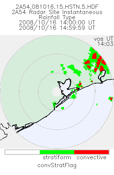
TRMM Ground Validation Radar Site Rain Type Map L2 1 hour 2 km V7 (TRMM_2A54) at GES DISC
National Aeronautics and Space Administration —
'Radar Site Convective/Stratiform Map', is an instantaneous map in Cartesian coordinates with a 2 km resolution. At single radar sites, the map covers an area of 300... -
Federal
OCO-2 Level 1B calibrated, geolocated calibration spectra V11.2 (OCO2_L1B_Calibration) at GES DISC
National Aeronautics and Space Administration —
Version 11.2 is the current version of the data set. Older versions will no longer be available and are superseded by Version 11.2. The Orbiting Carbon Observatory is... -
Federal
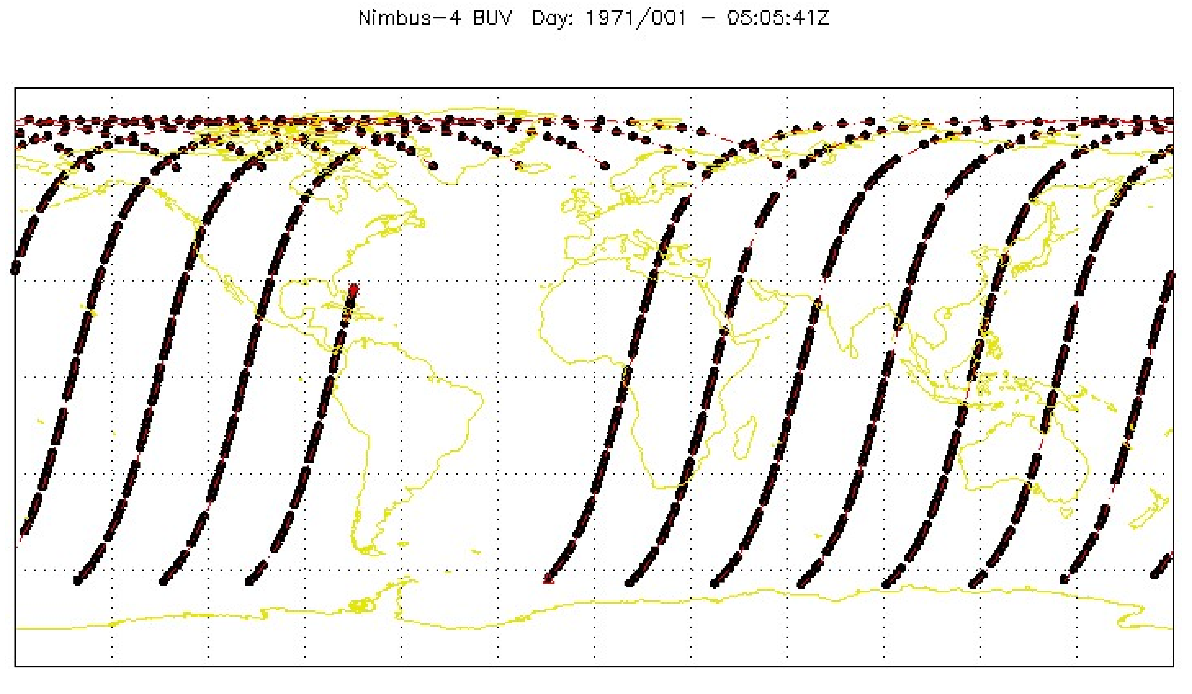
BUV/Nimbus-4 Level 1 Radiance Data V001 (BUVN4L1RUT) at GES DISC
National Aeronautics and Space Administration —
The Nimbus-4 BUV Level-1 Radiance data collection was derived from the Primary Data Base (PDB) product and contains the calibrated and geolocated backscattered... -
Federal
OCO-3 Level 2 geolocated XCO2 retrievals results, physical model, Forward Processing V10 (OCO3_L2_Standard) at GES DISC
National Aeronautics and Space Administration —
Version 10 is the current version of the data set. Older versions will no longer be available and are superseded by Version 10. The Orbiting Carbon Observatory -3... -
Federal
TOVS GLA DAILY GRIDS from NOAA-10 V01 (TOVSADNG) at GES DISC
National Aeronautics and Space Administration —
This dataset (TOVSADNG) contains the TIROS Operational Vertical Sounder (TOVS) level 3 geophysical parameters derived using data from NOAA-10 and the physical... -
Federal
OCO-2 Level 2 spatially ordered geolocated retrievals screened using the A-band Preprocessor V11.2 (OCO2_L2_ABand) at GES DISC
National Aeronautics and Space Administration —
Version 11.2 is the current version of the data set. Older versions will no longer be available and are superseded by Version 11.2. The Orbiting Carbon Observatory is... -
Federal
Sentinel-5P TROPOMI Aerosol Layer Height 1-Orbit L2 7km x 3.5km V1 (S5P_L2__AER_LH) at GES DISC
National Aeronautics and Space Administration —
Starting from August 6th in 2019, Sentinel-5P TROPOMI along-track high spatial resolution (~5.5km at nadir) has been implemented. For data after August 6th of 2019,... -
Federal
TRMM Ground Validation Radar Site 3D Rain Map L3 1 month 2 km V7 (TRMM_3A55) at GES DISC
National Aeronautics and Space Administration —
The 3A55, 'Monthly 3-D Structure', provides radar site monthly 3-D structure information obtained from 2A55. The 2A55 'Radar Site 3-D Reflectivities', is composed of...

Official websites use .gov
A
.gov website belongs to an official government
organization in the United States.
Secure .gov websites use HTTPS
A
lock (
) or https:// means you’ve safely connected to
the .gov website. Share sensitive information only on official,
secure websites.