
-
Federal
GLDAS Noah Land Surface Model L4 monthly 0.25 x 0.25 degree V2.1 (GLDAS_NOAH025_M) at GES DISC recent views
National Aeronautics and Space Administration —
NASA Global Land Data Assimilation System Version 2 (GLDAS-2) has three components: GLDAS-2.0, GLDAS-2.1, and GLDAS-2.2. GLDAS-2.0 is forced entirely with the... -
Federal
OMI/Aura Near UV Aerosol Optical Depth and Single Scattering Albedo 1-orbit L2 Swath 13x24 km V004 (OMAERUV) at GES DISC recent views
National Aeronautics and Space Administration —
The Aura Ozone Monitoring Instrument level-2 near UV Aerosol data product OMAERUV (Version 004) is available from the NASA Goddard Earth Sciences Data and Information... -
Federal
GLDAS Noah Land Surface Model L4 3 hourly 0.25 x 0.25 degree V2.0 (GLDAS_NOAH025_3H) at GES DISC recent views
National Aeronautics and Space Administration —
NASA Global Land Data Assimilation System Version 2 (GLDAS-2) has three components: GLDAS-2.0, GLDAS-2.1, and GLDAS-2.2. GLDAS-2.0 is forced entirely with the... -
Federal
GLDAS Catchment Land Surface Model L4 daily 0.25 x 0.25 degree GRACE-DA1 V2.2 (GLDAS_CLSM025_DA1_D) at GES DISC recent views
National Aeronautics and Space Administration —
NASA Global Land Data Assimilation System Version 2 (GLDAS-2) has three components: GLDAS-2.0, GLDAS-2.1, and GLDAS-2.2. GLDAS-2.0 is forced entirely with the... -
Federal
GLDAS Noah Land Surface Model L4 3 hourly 0.25 x 0.25 degree V2.1 (GLDAS_NOAH025_3H) at GES DISC recent views
National Aeronautics and Space Administration —
NASA Global Land Data Assimilation System Version 2 (GLDAS-2) has three components: GLDAS-2.0, GLDAS-2.1, and GLDAS-2.2. GLDAS-2.0 is forced entirely with the... -
Federal
OMPS-NPP L2 NM Aerosol Index swath orbital recent views
National Aeronautics and Space Administration —
The OMPS-NPP L2 NM Aerosol Index swath orbital product provides aerosol index values from the Ozone Mapping and Profiling Suite (OMPS) Nadir-Mapper (NM) instrument on... -
Federal
MERRA-2 tavg1_2d_lnd_Nx: 2d,1-Hourly,Time-Averaged,Single-Level,Assimilation,Land Surface Diagnostics 0.625 x 0.5 degree V5.12.4 (M2T1NXLND) at GES DISC recent views
National Aeronautics and Space Administration —
M2T1NXLND (or tavg1_2d_lnd_Nx) is an hourly time-averaged 2-dimensional data collection in Modern-Era Retrospective analysis for Research and Applications version 2... -
Federal
CAR ECO3D BRDF Measurements V2 (CAR_ECO3D_BRDF) at GES DISC recent views
National Aeronautics and Space Administration —
This study provide critical measurements on 3-dimensional structure of vegetation, which is important for quantifying the amount of carbon stored in biomass. It... -
Federal
GLDAS Catchment Land Surface Model L4 daily 0.25 x 0.25 degree GRACE-DA1 V2.2 (GLDAS_CLSM025_DA1_D_EP) at GES DISC recent views
National Aeronautics and Space Administration —
NASA Global Land Data Assimilation System Version 2 (GLDAS-2) has three components: GLDAS-2.0, GLDAS-2.1, and GLDAS-2.2. GLDAS-2.0 is forced entirely with the... -
Federal
GLDAS Noah Land Surface Model L4 monthly 0.25 x 0.25 degree Early Product V2.1 (GLDAS_NOAH025_M_EP) at GES DISC recent views
National Aeronautics and Space Administration —
NASA Global Land Data Assimilation System Version 2 (GLDAS-2) has three components: GLDAS-2.0, GLDAS-2.1, and GLDAS-2.2. GLDAS-2.0 is forced entirely with the... -
Federal
GPM SSMIS on F17 (GPROF) Climate-based Radiometer Precipitation Profiling L3 1 day 0.25 degree x 0.25 degree V07 (GPM_3GPROFF17SSMIS_DAY_CLIM) at GES DISC recent views
National Aeronautics and Space Administration —
Version 07 is the current version of the data set. Older versions will no longer be available and have been superseded by Version 07. The "CLIM" products differ from... -
Federal
GPM GMI XCAL Common Calibrated Brightness Temperatures L1BASE 1.5 hours 13 km V07 (GPM_BASEGPMGMI_XCAL) at GES DISC recent views
National Aeronautics and Space Administration —
Version 07 is the current version of the data set. Older versions are no longer available and have been superseded by the current version. Consistent rainfall... -
Federal
THIR/Nimbus-4 Level 1 Meteorological Radiation Data at 6.7 microns V001 (THIRN4L1CH67) at GES DISC recent views
National Aeronautics and Space Administration —
THIRN4L1CH67 is the Nimbus-4 Temperature-Humidity Infrared Radiometer (THIR) Level 1 Meteorological Radiation Data at 6.7 microns product contains radiances expressed... -
Federal
VISSR/SMS-2 Visible Imagery on 70mm Film V001 (VISSRSMS2IMVIS) at GES DISC recent views
National Aeronautics and Space Administration —
VISSRSMS2IMVIS is the Visible Infrared Spin-Scan Radiometer (VISSR) Visible Imagery on 70mm Film data product from the second Synchronous Meteorological Satellite... -
Federal
VISSR/GOES-3 Visible Imagery on 70mm Film V001 (VISSRGOES3IMVIS) at GES DISC recent views
National Aeronautics and Space Administration —
VISSRGOES3IMVIS is the Visible Infrared Spin-Scan Radiometer (VISSR) Visible Imagery on 70mm Film data product from the third Geostationary Operational Environmental... -
Federal
MERRA-2 tavg3_3d_rad_Np: 3d,3-Hourly,Time-Averaged,Pressure-Level,Assimilation,Radiation Diagnostics 0.625 x 0.5 degree V5.12.4 (M2T3NPRAD) at GES DISC recent views
National Aeronautics and Space Administration —
M2T3NPRAD (or tavg3_3d_rad_Np) is a 3-dimensional 3-hourly time averaged data collection in Modern-Era Retrospective analysis for Research and Applications version 2... -
Federal
OCO-2 Level 1B calibrated, geolocated calibration spectra V11.2 (OCO2_L1B_Calibration) at GES DISC recent views
National Aeronautics and Space Administration —
Version 11.2 is the current version of the data set. Older versions will no longer be available and are superseded by Version 11.2. The Orbiting Carbon Observatory is... -
Federal
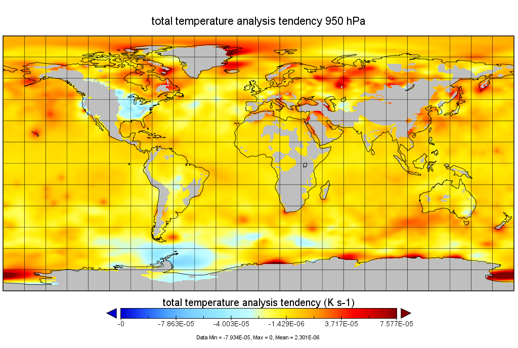
MERRA-2 tavgU_3d_tdt_Np: 3d,diurnal,Time-Averaged,Pressure-Level,Assimilation,Temperature Tendencies 0.625 x 0.5 degree V5.12.4 (M2TUNPTDT) at GES DISC recent views
National Aeronautics and Space Administration —
M2TUNPTDT (or tavgU_3d_tdt_Np) is a 3-dimensional monthly diurnal means data collection in Modern-Era Retrospective analysis for Research and Applications version 2... -
Federal
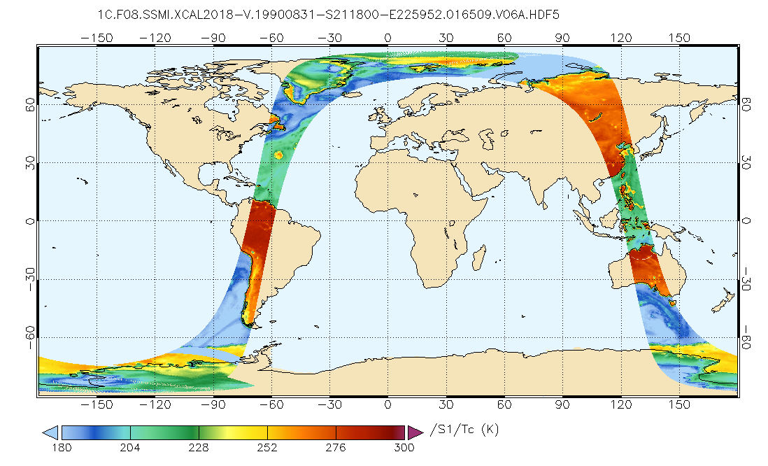
GPM SSMI on F08 Common Calibrated Brightness Temperatures L1C 1.5 hours 13 km V07 (GPM_1CF08SSMI) at GES DISC recent views
National Aeronautics and Space Administration —
All 1C products have a common L1C data structure, simple and generic. Each L1C swath includes scan time, latitude and longitude, scan status, quality, incidence... -
Federal
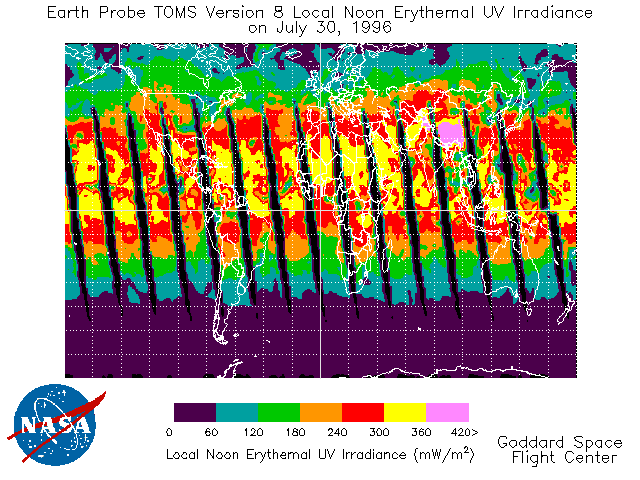
TOMS Earth Probe UV-B Erythemal Local Noon Irradiance Daily L3 Global 1 deg x 1.25 deg Lat/Lon Grid V008 (TOMSEPL3dery) at GES DISC recent views
National Aeronautics and Space Administration —
This Earth Probe (EP) Total Ozone Mapping Spectrometer (TOMS) version 8 daily global gridded data product contains UV-B erythemal local noon irradiance values. The...

Official websites use .gov
A
.gov website belongs to an official government
organization in the United States.
Secure .gov websites use HTTPS
A
lock (
) or https:// means you’ve safely connected to
the .gov website. Share sensitive information only on official,
secure websites.