
-
Federal
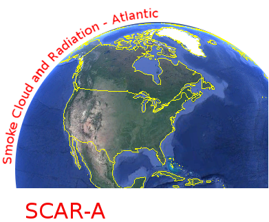
CAR SCAR-A Sulfates, Clouds, and Radiation-Atlantic L1 V1 (CAR_SCARA_L1C) at GES DISC
National Aeronautics and Space Administration —
The objectives for the SCAR mission are to advance our knowledge of how the physical, chemical and radiative processes in our atmosphere are affected by sulfate... -
Federal
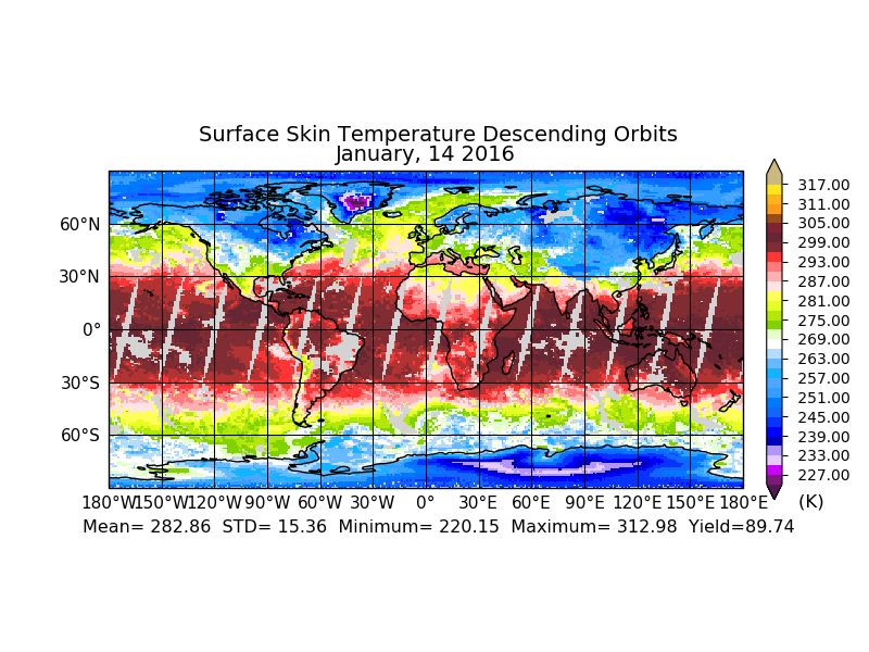
Sounder SIPS: Suomi NPP CrIMSS Level 3 Comprehensive Quality Control Gridded Daily CHART Normal Spectral Resolution V1
National Aeronautics and Space Administration —
The objective of this limited edition data collection is to examine products generated by the Climate Heritage AIRS Retrieval Technique (CHART) algorithm to analyze... -
Federal
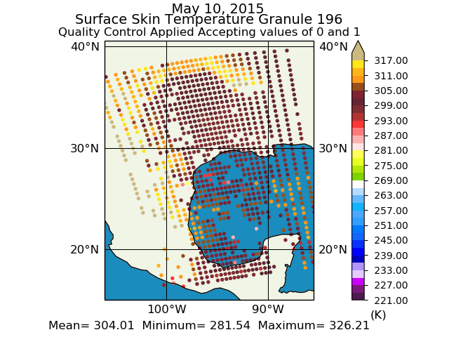
Sounder SIPS: Suomi NPP CrIMSS Level 2 CHART Normal Spectral Resolution: Atmosphere, cloud and surface geophysical state V1
National Aeronautics and Space Administration —
The objective of this limited edition data collection is to examine products generated by the Climate Heritage AIRS Retrieval Technique (CHART) algorithm to analyze... -
Federal
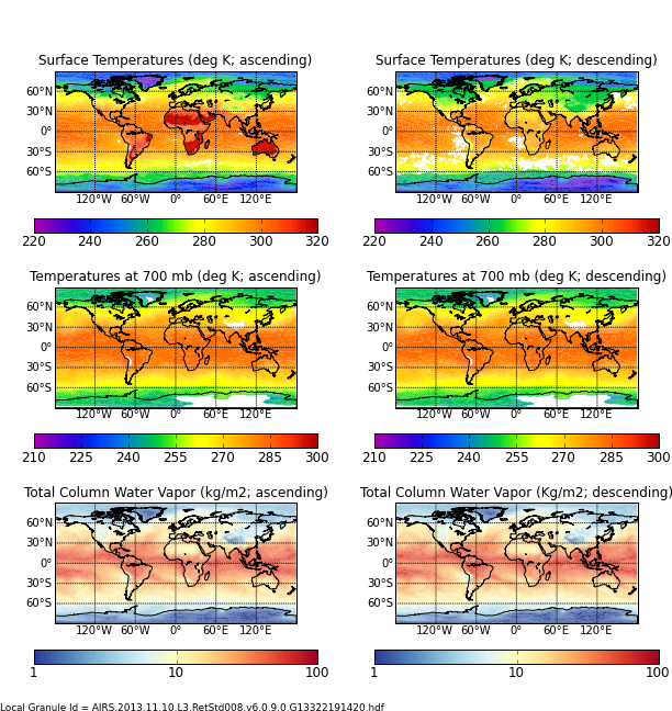
AIRS/Aqua L3 8-day Support Multiday Product (AIRS+AMSU+HSB) 1 degree x 1 degree V006 (AIRH3SP8) at GES DISC
National Aeronautics and Space Administration —
The Atmospheric Infrared Sounder (AIRS) is a grating spectrometer (R = 1200) aboard the second Earth Observing System (EOS) polar-orbiting platform, EOS Aqua. In... -
Federal
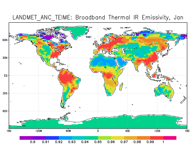
LANDMET Ancillary Monthly Mean Thermal Effective Infrared and Microwave Emissivity Data L3 V1 (LANDMET_ANC_TEIME) at GES DISC
National Aeronautics and Space Administration —
This is an ancillary product, climatology monthly mean and standard deviation, containing a number of emissivity data. They are broadband thermal IR emissivity from... -
Federal
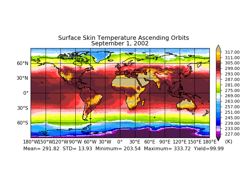
Aqua/AIRS L3 Monthly Standard Physical Retrieval (AIRS+AMSU+HSB) 1 degree x 1 degree V7.0 at GES DISC
National Aeronautics and Space Administration —
The Atmospheric Infrared Sounder (AIRS) is a grating spectrometer (R = 1200) aboard the second Earth Observing System (EOS) polar-orbiting platform, EOS Aqua. In... -
Federal
Sounder SIPS: Suomi NPP CrIMSS Level 3 Specific Quality Control Gridded Daily CLIMCAPS Full Spectral Resolution V2 at GES DISC
National Aeronautics and Space Administration —
WARNING: To users of the derived product “co_mmr_midtrop” (carbon monoxide mass mixing ratio to dry air [kg/kg] at ~500 hPa). This variable has a significant bias due... -
Federal
L2 Daily Solar-Induced Fluorescence (SIF) from ERS-2 GOME, 1995-2003
National Aeronautics and Space Administration —
This dataset provides Level 2 Solar-Induced Fluorescence (SIF) of Chlorophyll estimates derived from the Global Ozone Monitoring Experiment (GOME) instrument on the... -
Federal
ISLSCP II MODIS (Collection 4) Albedo, 2002 NGDA
National Aeronautics and Space Administration —
This International Satellite Land Surface Climatology Project (ISLSCP II) MODerate resolution Image Spectroradiometer (MODIS) dataset, ISLSCP II MODIS (Collection 4)... -
Federal
SAFARI 2000 Pre- and Post-fire Reflectance near Kaoma, Zambia, Dry Season 2000
National Aeronautics and Space Administration —
The main goal of this study was to analyze the possibility of estimating combustion completeness based on fire-induced spectral reflectance changes of surface... -
Federal
ISLSCP II FASIR-adjusted NDVI, 1982-1998 NGDA
National Aeronautics and Space Administration —
The Fourier-Adjusted, Sensor and Solar zenith angle corrected, Interpolated, Reconstructed (FASIR) adjusted Normalized Difference Vegetation Index (NDVI) data sets... -
Federal
ISLSCP II ECMWF Near-Surface Meteorology Parameters
National Aeronautics and Space Administration —
This data set for the ISLSCP Initiative II data collection provides meteorology data with fixed, monthly, monthly-6-hourly, 6-hourly, and 3-hourly temporal... -
Federal
ISLSCP II IGBP DISCover and SiB Land Cover, 1992-1993 NGDA
National Aeronautics and Space Administration —
This data set describes the geographic distributions of 17 classes of land cover based on the International Geosphere-Biosphere DISCover land cover legend (Loveland... -
Federal
ISLSCP II GIMMS Monthly NDVI, 1981-2002 NGDA
National Aeronautics and Space Administration —
The Global Inventory Modelling and Mapping Studies (GIMMS) Normalized Difference Vegetation Index (NDVI) data sets were generated to provide a 22-year satellite... -
Federal
LBA-ECO LC-01 Landsat MSS, TM, ETM+ Imagery, Northern Ecuadorian Amazon: 1973-2002
National Aeronautics and Space Administration —
This data set contains a time series of early Landsat-4 MSS satellite imagery as well as Landsat-5 TM and Landsat-7 ETM+ satellite imagery of the northern Ecuadorian... -
Federal
Hyperspectral Imagery from AVIRIS-NG for Sites in ID and CA, USA, 2014 and 2015
National Aeronautics and Space Administration —
This dataset provides surface reflectance measured by the Airborne Visible/Infrared Imaging Spectrometer-Next Generation (AVIRIS-NG) instrument during flights over... -
Federal
AIRS/Aqua L3 8-day Support Multiday Product (AIRS+AMSU) 1 degree x 1 degree V006 (AIRX3SP8) at GES DISC
National Aeronautics and Space Administration —
The Atmospheric Infrared Sounder (AIRS) is a grating spectrometer (R = 1200) aboard the second Earth Observing System (EOS) polar-orbiting platform, EOS Aqua. In... -
Federal
SAFARI 2000 Meteorological and Flux Tower Measurements in Maun, Botswana, 2000
National Aeronautics and Space Administration —
To investigate potential contributions of savanna ecosystems to the Earth's carbon balance, an eddy covariance system was used to measure the seasonal variation in... -
Federal
Aqua/AIRS L2 Support Retrieval (AIRS+AMSU) V7.0 at GES DISC
National Aeronautics and Space Administration —
The Atmospheric Infrared Sounder (AIRS) is a grating spectrometer (R = 1200) aboard the second Earth Observing System (EOS) polar-orbiting platform, EOS Aqua. In... -
Federal
ISLSCP II MODIS (Collection 4) IGBP Land Cover, 2000-2001 NGDA
National Aeronautics and Space Administration —
This data set, ISLSCP II MODIS (Collection 4) IGBP Land Cover, 2000-2001, contains global land cover classifications (dominant type, classification confidence and...

Official websites use .gov
A
.gov website belongs to an official government
organization in the United States.
Secure .gov websites use HTTPS
A
lock (
) or https:// means you’ve safely connected to
the .gov website. Share sensitive information only on official,
secure websites.