
-
Federal
KSC ADVANCED GROUND BASED FIELD MILL V1 recent views
National Aeronautics and Space Administration —
The Advanced Ground Based Field Mill (AGBFM) network consists of 34 (31 operational) field mills located at Kennedy Space Center (KSC), Florida. The field mills... -
Federal
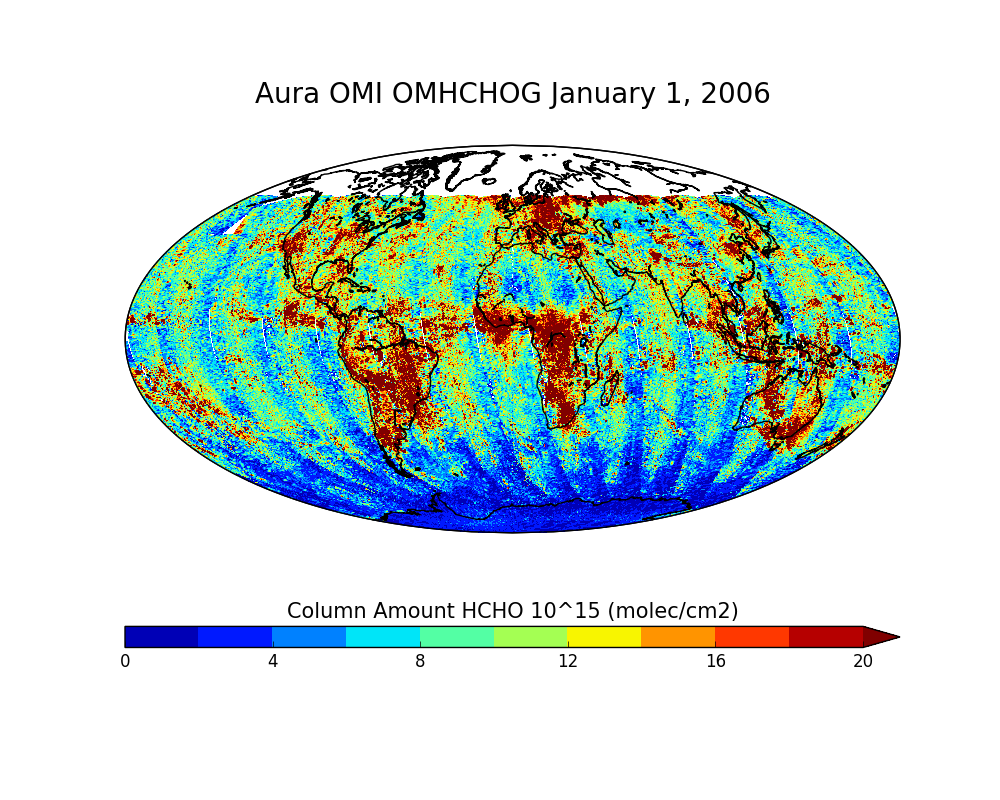
OMI/Aura Formaldehyde (HCHO) Total Column Daily L2 Global Gridded 0.25 degree x 0.25 degree V3 (OMHCHOG) at GES DISC recent views
National Aeronautics and Space Administration —
This Level-2G daily global gridded product OMHCHOG is based on the pixel level OMI Level-2 HCHO product OMHCHO. OMHCHOG data product is a special Level-2 Global... -
Federal
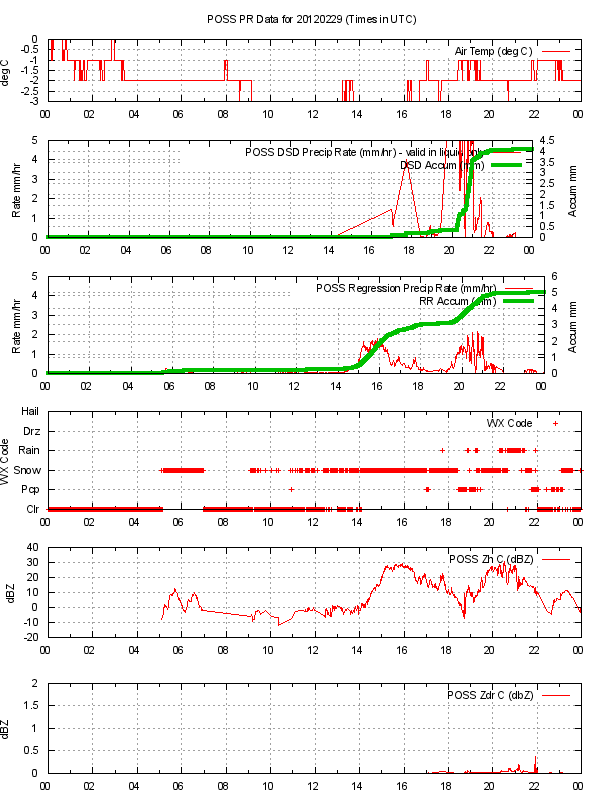
GPM GROUND VALIDATION ENVIRONMENT CANADA (EC) PRECIPITATION OCCURRENCE SENSOR SYSTEM (POSS) GCPEX V1 recent views
National Aeronautics and Space Administration —
The GPM Ground Validation Environment Canada (EC) Precipitation Occurrence Sensor System (POSS) GCPEx dataset is comprised of data gathered during the GPM Cold-season... -
Federal
Global 30-Year Mean Monthly Climatology, 1901-1960 (New et al.) recent views
National Aeronautics and Space Administration —
A data set of 30-year mean monthly surface climate over global land areas, excluding Antarctica. Interpolated from station data to 0.5 degree lat/lon for a range of... -
Federal
NACP Regional: Original Observation Data and Biosphere and Inverse Model Outputs recent views
National Aeronautics and Space Administration —
This data set contains the originally-submitted observation measurement data, terrestrial biosphere model output data, and inverse model simulations that various... -
Federal
UARS Wind Imaging Interferometer (WINDII) Level 3AL V011 (UARWI3AL) at GES DISC recent views
National Aeronautics and Space Administration —
The Wind Imaging Interferometer (WINDII) Level 3AL data product consists of daily, 4 degree increment latitude-ordered vertical profiles of meridional and zonal wind... -
Federal
Global Monthly Climatology for the Twentieth Century (New et al.) recent views
National Aeronautics and Space Administration —
A 0.5 degree lat/lon data set of monthly surface climate over global land areas, excluding Antarctica. Primary variables are interpolated directly from station time-... -
Federal
BOREAS TE-06 Multiband Vegetation Imager Data recent views
National Aeronautics and Space Administration —
Describes the average data values derived from the multi-vegetation imager used by TE-06 during the BOREAS project.Describes the single point data values derived from... -
Federal
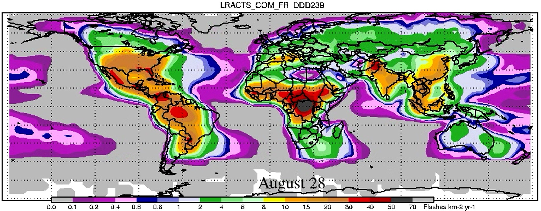
LIS/OTD 2.5 Degree Low Resolution Annual Climatology Time Series (LRACTS) V2.3.2015 recent views
National Aeronautics and Space Administration —
The LIS/OTD 2.5 Degree Low Resolution Annual Climatology Time Series (LRACTS) consists of gridded climatologies of total lightning flash rates seen by the spaceborne... -
Federal
BOREAS TE-10 Leaf Optical Properties for SSA Species recent views
National Aeronautics and Space Administration —
Data collected in support of efforts to characterize and interpret information on the reflectance, transmittance, gas exchange, oxygen evolution, and biochemical... -
Federal
UARS Correlative UKMO Daily Gridded Stratospheric Assimilated Data V001 (UARZCUKM) at GES DISC recent views
National Aeronautics and Space Administration —
The UARS Correlative assimilation data from the U.K. Meteorological Office (UKMO) consists of daily model runs at 12:00 GMT as a means of providing an independent... -
Federal
BOREAS HYD-03 1996 Tree Stem Density Data recent views
National Aeronautics and Space Administration —
The BOREAS HYD-03 team collected several data sets related to the hydrology of forested areas. This data set contains measurements of stem density from a variety of... -
Federal
NARSTO EPA Supersite (SS) Los Angeles Size-Fractionated Particulate Matter (PM) Composition - micro-orifice uniform deposit impactors (MOUDI) Data recent views
National Aeronautics and Space Administration —
The NARSTO_EPA_SS_LOS_ANGELES_MOUDI_DATA is the North American Research Strategy for Tropospheric Ozone (NARSTO) Environmental Protection Agency (EPA) Supersite (SS)... -
Federal
BOREAS TE-05 Tree Ring and Carbon Isotope Ratio Data recent views
National Aeronautics and Space Administration —
Contains tree ring width and C13 isotope cellulose ratio data collected by TE-05. -
Federal
BOREAS AFM-03 NCAR Electra 1994 Aircraft Sounding Data recent views
National Aeronautics and Space Administration —
Measurements of wind speed and direction, air pressure and temperature, potential temperature, dewpoint, mixing ratio of H2O, CO2 concentration, and ozone... -
Federal
BOREAS RSS-14 GOES-7 Level-1 Visible, Infrared, and Water Vapor Images recent views
National Aeronautics and Space Administration —
The level-1 BOREAS GOES-7 image data were collected by Remote Sensing Science Team 14 (RSS-14) personnel at Florida State University (FSU) and delivered to BORIS. The... -
Federal
BOREAS TF-11 CO2 and CH4 Flux Data from the SSA-Fen recent views
National Aeronautics and Space Administration —
Contains CH4 and CO2 static chamber fluxes at the SSA-FEN. -
Federal
OMI/Aura TOMS-Like Ozone and Radiative Cloud Fraction L3 1 day 0.25 degree x 0.25 degree V3 (OMTO3e) at GES DISC recent views
National Aeronautics and Space Administration —
The OMI science team produces this Level-3 Aura/OMI Global TOMS-Like Total Column Ozone gridded product OMTO3e (0.25deg Lat/Lon grids). The OMTO3e product selects the... -
Federal
BOREAS TE-06 Biomass and Foliage Area Data recent views
National Aeronautics and Space Administration —
Contains biomass data collected by TE-06. -
Federal
UARS Improved Stratospheric and Mesospheric Sounder (ISAMS) Level 3AL V010 (UARIS3AL) at GES DISC recent views
National Aeronautics and Space Administration —
The Improved Stratospheric and Mesospheric Sounder (ISAMS) Level 3AL data product consists of daily, 4 degree increment latitude-ordered vertical profiles of...

Official websites use .gov
A
.gov website belongs to an official government
organization in the United States.
Secure .gov websites use HTTPS
A
lock (
) or https:// means you’ve safely connected to
the .gov website. Share sensitive information only on official,
secure websites.