
-
Federal
Continued Geophysical Logging in the vicinity of the GMH Electronics Superfund Site near Roxboro North Carolina
Department of the Interior —
The collection of borehole geophysical logs and images and continuous water-level data was conducted by the U.S. Geological Survey South Atlantic Water Science Center... -
Federal
EPA RE-Powering Mapper Feasibility Studies
U.S. Environmental Protection Agency —
The U.S. Environmental Protection Agency (EPA) Office of Land and Emergency Management (OLEM) Office of Communications, Partnerships and Analysis (OCPA) initiated the... -
Federal
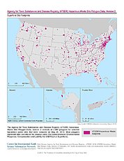
ATSDR Hazardous Waste Site Polygon Data with CIESIN Modifications, Version 2
National Aeronautics and Space Administration —
The Agency for Toxic Substances and Disease Registry (ATSDR) Hazardous Waste Site Polygon Data with CIESIN Modifications, Version 2 is a database providing... -
Federal
EPA Facility Registry Service (FRS): ER_CERCLIS
U.S. Environmental Protection Agency —
This web feature service contains location and facility identification information from EPA's Facility Registry System (FRS) for the subset of facilities that link to... -
Federal
Per- and polyfluoroalkyl substances (PFAS), volatile organic compounds, biogeochemical, and water quality data from seep samples, Lower Darby Creek Area Superfund Site, near Folcroft, Pennsylvania, 2024
Department of the Interior —
This metadata record contains one table and one shapefile with results from field sampling at locations of groundwater discharge (seeps) identified by autonomous boat... -
Federal
Boundaries of EPA R6 NPL Sites as of 3/1/2023; EPA Region 6 Superfund, AR, LA, NM, OK, TX
U.S. Environmental Protection Agency —
This layer contains boundaries of EPA Region 6 Superfund NPL Sites as of 3/1/2023. The boundaries represent several types of features such as operable units, plumes,... -
Federal
FFRRO Program Information
U.S. Environmental Protection Agency —
This asset includes information related to Cleanups at Federal Facilities. Information is provided about contaminated federal facility sites in specific communities,... -
Federal
Portland Harbor Phase 3 Subyearling Chinook 2018 Samples
National Oceanic and Atmospheric Administration, Department of Commerce —
The Upper Willamette River (UWR) Chinook salmon Ecologically Significant Unit (ESU) includes naturally spawned Chinook salmon originating from the Clackamas River and... -
Federal
FLIR camera thermal imagery for stream sites at the Hemphill Road TCE NPL Superfund Site near Gastonia, North Carolina
Department of the Interior —
The data on this page contain .pdf files of thermal images collected at 10 stream sites nearby study area, showing stream surface and bank seepage temperature readings. -
Federal
Environmental (hydrogen, oxygen, and sulfur) stable isotope data from the Elizabeth copper mine Superfund site, Vermont, USA
Department of the Interior —
Stable hydrogen (H), oxygen (O), and sulfur (S) isotope data were collected from the Elizabeth copper mine Superfund site, South Strafford, Vermont. Sample media... -
Federal
EPA R6 Superfund NPL Site Locations as of 3/31/2023; EPA Region 6 Superfund, AR, LA, NM, OK, TX
U.S. Environmental Protection Agency —
Point locations for sites in EPA Region 6 which are documented as being part of the National Priorities List as of 3/31/2023. The locations were determined by EPA... -
Federal
Water level data during pumping for stressed HPFM measurements for selected boreholes near GMH Electronics Superfund site, Roxboro, NC (2012-2015)
Department of the Interior —
The collection of borehole geophysical logs and images and continuous water-level data was conducted by the U.S. Geological Survey South Atlantic Water Science Center... -
Federal
MODFLOW-2005, MODPATH, and MOC3D used for groundwater flow simulation, pathlines analysis, and solute transport in the crystalline-rock aquifer in the vicinity of the Savage Municipal Water-Supply Well Superfund Site, Milford, New Hampshire
Department of the Interior —
The U.S. Geological Survey, in cooperation with the U.S. Environmental Protection Agency and the New Hampshire Department of Environmental Services, developed a model... -
Federal
Computed daily metallic-contaminant concentrations and loads on the Clark Fork River at USGS streamgages 12324200 and 12324400 near Grant-Kohrs Ranch National Historic Site in southwestern Montana, Water Years 2019-20
Department of the Interior —
In 2019, the U.S. Geological Survey (USGS), in cooperation with the National Park Service, initiated a study using surrogate technology to predict real-time metallic-... -
Federal
Contaminant Data and Growth and Survival Measurements From Juvenile Chinook Salmon Dietary Exposure Study 2020-02-02 to 2021-04-19 (NCEI Accession 0290149)
National Oceanic and Atmospheric Administration, Department of Commerce —
The data included in this package were conducted as part of a Natural Resource Damage Assessment (NRDA) addressing historical pollution at the designated Superfund... -
Federal
Portland Harbor Benthic Invertebrate Growth and Survival 2004 - 2007 (NCEI Accession 0301784)
National Oceanic and Atmospheric Administration, Department of Commerce —
The lower Willamette River, between Willamette Falls and the confluence with the Columbia River, in Portland, Oregon has a long history of industrialization and... -
Federal
Surface-Water Geochemistry of Mercury, Methylmercury, Nutrients, and other Constituents in Clear Lake, Lake County, California, July 2019
Department of the Interior —
Clear Lake is a 180 km2 freshwater lake located in the California Coast Range, approximately 120 km northwest of Sacramento. The lake supports a wide variety of fish... -
Federal
U.S. EPA National Priorities List (NPL) Sites Point Data with CIESIN Modifications, Version 2
National Aeronautics and Space Administration —
The U.S. Environmental Protection Agency (EPA) National Priorities List (NPL) Sites Point Data with CIESIN Modifications, Version 2 is a modified version of the 2014... -
Federal
ATSDR Hazardous Waste Site Polygon Data, Version 2
National Aeronautics and Space Administration —
The Agency for Toxic Substances and Disease Registry (ATSDR) Hazardous Waste Site Polygon Data, Version 2 consists of 2,080 polygons for selected hazardous waste... -
Federal
Outer Boundaries of EPA R6 NPL Sites as of 3/1/2023; EPA Region 6 Superfund, AR, LA, NM, OK, TX
U.S. Environmental Protection Agency —
This layer contains one boundary (one record) for each EPA Region 6 Superfund NPL Site as of 3/1/2023. Each boundary represents the outer lines of the site.

Official websites use .gov
A
.gov website belongs to an official government
organization in the United States.
Secure .gov websites use HTTPS
A
lock (
) or https:// means you’ve safely connected to
the .gov website. Share sensitive information only on official,
secure websites.