
-
Federal
NACP North American Forest Dynamics Project: Forest Disturbance and Regrowth Data 19 recent views
National Aeronautics and Space Administration —
This data set provides the results of time-series analyses of Landsat imagery for 55 selected forested sites across the conterminous U.S.A. The output is a pair of... -
Federal
Tree Mortality from Fires and Bark Beetles at 1-km Resolution, Western USA, 2003-2012
National Aeronautics and Space Administration —
This dataset provides annual estimates of tree mortality due to fires and bark beetles from 2003 to 2012 on forestland in the continental western United States. Tree... -
Federal
NACP Forest Age Maps at 1-km Resolution for Canada (2004) and the U.S.A. (2006)
National Aeronautics and Space Administration —
This data set provides forest age map products at 1-km resolution for Canada and the United States (U.S.A.). These continental forest age maps were compiled from... -
Federal
Forest Carbon Stocks and Fluxes from the NFCMS, Conterminous USA, 1990-2010
National Aeronautics and Space Administration —
This dataset, derived from the National Forest Carbon Monitoring System (NFCMS), provides estimates of forest carbon stocks and fluxes in the form of aboveground... -
Federal
NACP: Forest Carbon Stocks, Fluxes and Productivity Estimates, Western USA, 1979-2099
National Aeronautics and Space Administration —
This dataset contains annual estimates of carbon stocks, fluxes, and productivity over forested land in 11 states of the western USA (Arizona, California, Colorado,... -
Federal
MERRA-2 tavgU_2d_lnd_Nx: 2d,diurnal,Time-Averaged,Single-Level,Assimilation,Land Surface Diagnostics 0.625 x 0.5 degree V5.12.4 (M2TUNXLND) at GES DISC
National Aeronautics and Space Administration —
M2TUNXLND (or tavgU_2d_lnd_Nx) is a time-averaged 2-dimensional monthly diurnal means data collection in Modern-Era Retrospective analysis for Research and... -
Federal
Mowing Experiment Biophys. Data (FIFE)
National Aeronautics and Space Administration —
Plant biomass data where grazing height or frequency were simulated by mowing -
Federal
LBA-ECO CD-05 Understory Fuel Stick Moisture, km 67 Site, Para, Brazil: 1998-2000
National Aeronautics and Space Administration —
This data set contains moisture content measurements for fuel sticks located in the forest understory of the rainfall exclusion experimental site, Tapajos National... -
Federal
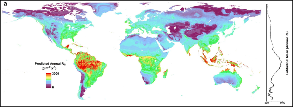
Global Gridded 1-km Annual Soil Respiration and Uncertainty Derived from SRDB V3
National Aeronautics and Space Administration —
This dataset provides six global gridded products at 1-km resolution of predicted annual soil respiration (Rs) and associated uncertainty, maps of the lower and upper... -
Federal
NPP Multi-Biome: Summary Data from Intensive Studies at 125 Sites, 1936-2006
National Aeronautics and Space Administration —
This data set, NPP Multi-Biome: Summary Data from Intensive Studies at 125 Sites, 1936-2006, contains a single shapefile that provides site-level summary statistics... -
Federal
LBA-ECO TG-05 NPP, Carbon Pool, Soil Characteristics, Soil Gas Flux Maps of Brazil
National Aeronautics and Space Administration —
This data set provides maps produced from model output data from the National Aeronautics and Space Administration-Carnegie Ames Stanford Approach (NASA-CASA) model... -
Federal
BOREAS TGB-12 Soil Carbon and Flux Data of NSA-MSA in Raster Format
National Aeronautics and Space Administration —
This data set contains (1) estimates of soil carbon stocks by horizon based on soil survey data and analyses of data from individual soil profiles; (2) estimates of... -
Federal
BOREAS TF-01 SSA-OA Understory Flux, Meteorological, and Soil Temperature Data
National Aeronautics and Space Administration —
Energy, carbon dioxide, and momentum flux data collected under the canopy along with meteorological and soils data at the BOREAS SSA-OA site from mid-October to mid-... -
Federal
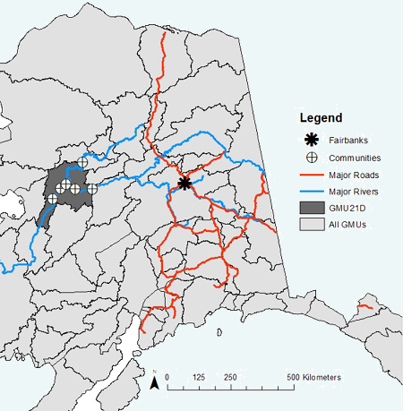
ABoVE: Environmental Conditions During Fall Moose Hunting Seasons, Alaska, 2000-2016 NGDA
National Aeronautics and Space Administration —
This dataset provides daily and annual air temperature, river water level, and leaf drop dates coincident with the moose (Alces alces) hunting season (September) for... -
Federal
LBA-ECO CD-05 Forest Understory Fuel Loads, Paragominas, Para, Brazil: 2001
National Aeronautics and Space Administration —
This data set contains estimates of understory fuel loads (forest litter) at six locations near Paragominas in Northeastern Amazonia. Samples were collected from... -
Federal
Geoecology: County-Level Environmental Data for the United States, 1941-1981
National Aeronautics and Space Administration —
The Geoecology database is a compilation of environmental data for the period 1941 to 1981. The Geoecology database contains selected data on terrain and soils, water... -
Federal
Global 1-degree Maps of Forest Area, Carbon Stocks, and Biomass, 1950-2010
National Aeronautics and Space Administration —
This data set provides global forest area, forest growing stock, and forest biomass data at 1-degree resolution for the period 1950-2010. The data set is based on a... -
Federal
NACP Regional: Supplemental Gridded Observations, Biosphere and Inverse Model Outputs NGDA
National Aeronautics and Space Administration —
This data set contains standardized gridded observation data, terrestrial biospheric model output, and inverse model simulations that were compiled but not used in... -
Federal
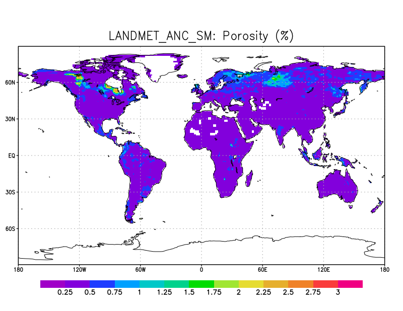
LANDMET Ancillary Soil Moisture data L3 V1 (LANDMET_ANC_SM) at GES DISC
National Aeronautics and Space Administration —
This ancillary climatology soil porosity and wetlands coverage information were derived from the daily GEWEX fusion of satellite active and passive microwave... -
Federal
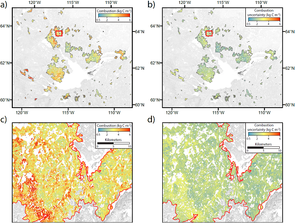
ABoVE: Wildfire Carbon Emissions and Burned Plot Characteristics, NWT, CA, 2014-2016
National Aeronautics and Space Administration —
This dataset provides estimates of wildfire carbon emissions and uncertainties at 30-m resolution, and measurements collected at burned and unburned field plots from...

Official websites use .gov
A
.gov website belongs to an official government
organization in the United States.
Secure .gov websites use HTTPS
A
lock (
) or https:// means you’ve safely connected to
the .gov website. Share sensitive information only on official,
secure websites.