
-
Federal
U.S. Billion-dollar Weather and Climate Disasters, 1980 - present (NCEI Accession 0209268)
National Oceanic and Atmospheric Administration, Department of Commerce —
The NOAA National Centers for Environmental Information ceased providing support for this product in May 2025 in response to an initiative to implement reductions... -
Federal
Datasets managed by the NSF Arctic Data Center and archived at the NOAA National Centers for Environmental Information
National Oceanic and Atmospheric Administration, Department of Commerce —
The National Science Foundation (NSF) Arctic Data Center (ADC) preserves and provides access to multi-disciplinary NSF-funded global cryosphere-land-ocean-atmosphere... -
Federal
NOAA/WDS Paleoclimatology - Power et al. 2008 Global Charcoal Database
National Oceanic and Atmospheric Administration, Department of Commerce —
This archived Paleoclimatology Study is available from the NOAA National Centers for Environmental Information (NCEI), under the World Data Service (WDS) for... -
Federal
National Interagency Fire Occurrence Sixth Edition 1992-2020 (Feature Layer)
Department of Agriculture —
This data publication contains a spatial database of wildfires that occurred in the United States from 1992 to 2020. It is the fifth update of a publication... -
Federal
Wildland Urban Interface: 2020 (Map Service)
Department of Agriculture —
The Wildland-Urban Interface (WUI) is the area where houses meet or intermingle with undeveloped wildland vegetation. This makes the WUI a focal area for human-... -
Federal
National USFS Fire Occurrence Point (Feature Layer)
Department of Agriculture —
The FireOccurrence point layer represents ignition points, or points of origin, from which individual USFS wildland fires started. Data are maintained at the... -
Federal
BLM Natl AIM TerrADat Hub
Department of the Interior —
This feature class includes monitoring data collected nationally to understand the status, condition, and trend of resources on BLM lands. It focuses on the BLM... -
Federal
Wildfire Hazard Potential, Version 2023 Continuous (Image Service)
Department of Agriculture —
Note: This Wildfire Hazard Potential (WHP) image service has been deprecated. Previous versions—including 2014, 2018, 2020, and 2023 continuous and classified... -
Federal
BIA Regions
Department of the Interior —
Delivery of program services to the federally recognized tribes and individual Indians and Alaska Natives, whether directly or through contracts, grants or compacts,... -
Federal
VIIRS/NPP Thermal Anomalies and Fire Daily L3 Global 1km SIN Grid V001
National Aeronautics and Space Administration —
The daily NASA/NOAA Suomi National Polar-orbiting Partnership (Suomi NPP) Visible Infrared Imaging Radiometer Suite (VIIRS) Thermal Anomalies/Fire (VNP14A1) Version 1... -
Federal
National Interagency Fire Occurrence Fifth Edition 1992-2018 (Feature Layer)
Department of Agriculture —
Note: This is a large dataset. To download, go to ArcGIS Open Data Set and click the download button, and under additional resources select the geodatabase or... -
Federal
FIRESTAT Fire Occurrence - Yearly Update (Feature Layer)
Department of Agriculture —
The FIRESTAT (Fire Statistics System) Fire Occurrence point layer represents ignition points, or points of origin, from which individual wildland fires started on... -
Federal
Volcanic Rocks and Features
National Oceanic and Atmospheric Administration, Department of Commerce —
Volcanoes have contributed significantly to the formation of the surface of our planet. Volcanism produced the crust we live on and most of the air we breathe. The... -
Federal
Danger Zones and Restricted Areas
National Oceanic and Atmospheric Administration, Department of Commerce —
These data represent the location of Danger Zones and Restricted Areas within coastal and marine waters, as outlined by the Code of Federal Regulations (CFR) and the... -
Federal
Activity FACTS Common Attributes (Feature Layer)
Department of Agriculture —
The data in this map service is updated every weekend.Note: This data includes all activities regardless of whether there is a spatial feature attached.Note: This is... -
Federal
National USFS Fire Perimeter (Feature Layer)
Department of Agriculture —
The FirePerimeter polygon layer represents daily and final mapped wildland fire perimeters. Incidents of 10 acres or greater in size are expected. Incidents smaller... -
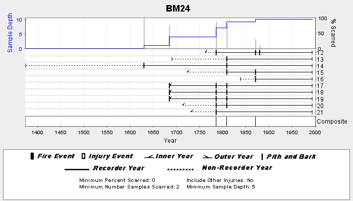
Federal
NOAA/WDS Paleoclimatology - Veblen fire data from BM24 - IMPD USBM-024
National Oceanic and Atmospheric Administration, Department of Commerce —
This archived Paleoclimatology Study is available from the NOAA National Centers for Environmental Information (NCEI), under the World Data Service (WDS) for... -
Federal
Probabilistic Wildfire Risk Flame Length Probability 2 (Image Service)
Department of Agriculture —
National data on burn probability (BP) and conditional flame-length probability (FLP) were generated for the conterminous United States (CONUS), Alaska, and Hawaii... -
Federal
NOAA/WDS Paleoclimatology - Smith - Van Bibber Creek Recollection - PIPO - ITRDB CO698
National Oceanic and Atmospheric Administration, Department of Commerce —
This archived Paleoclimatology Study is available from the NOAA National Centers for Environmental Information (NCEI), under the World Data Service (WDS) for... -
Federal
NOAA/WDS Paleoclimatology - Swetnam fire data from Animas Peak - IMPD USANP002
National Oceanic and Atmospheric Administration, Department of Commerce —
This archived Paleoclimatology Study is available from the NOAA National Centers for Environmental Information (NCEI), under the World Data Service (WDS) for...

Official websites use .gov
A
.gov website belongs to an official government
organization in the United States.
Secure .gov websites use HTTPS
A
lock (
) or https:// means you’ve safely connected to
the .gov website. Share sensitive information only on official,
secure websites.