
-
Federal
HRIR/Nimbus-3 Images of Daytime and Nighttime Brightness Temperature on 70 mm Film V001 (HRIRN3IM) at GES DISC recent views
National Aeronautics and Space Administration —
HRIRN3IM is the Nimbus-3 High-Resolution Infrared Radiometer (HRIR) data product containing scanned negatives of photofacsimile 70mm film strips. The images contain... -
Federal
HRIR/Nimbus-3 Level 1 Meteorological Radiation Data V001 (HRIRN3L1) at GES DISC recent views
National Aeronautics and Space Administration —
HRIRN3L1 is the High Resolution Infrared Radiometer (HRIR) Nimbus-3 Level 1 Meteorological Radiance Data (NMRT) product and contains infrared radiances converted to... -
Federal
ITPR/Nimbus-5 Level 1 Calibrated Radiances V001 (ITPRN5L1) at GES DISC recent views
National Aeronautics and Space Administration —
ITPRN5L1 is the Nimbus-5 Infrared Temperature Profile Radiometer (ITPR) Level-1 Calibrated Radiances data product which contains radiances at 7 infrared spectral... -
Federal
ESMR/Nimbus-6 Images of Brightness Temperature on 70 mm Film V001 (ESMRN6IM) at GES DISC recent views
National Aeronautics and Space Administration —
ESMRN6IM is the Nimbus-6 Electrically Scanning Microwave Radiometer (ESMR) data product containing daily brightness temperature images from 70-mm photofacsimile film... -
Federal
Data over the SSA in Raster Format and AEAC Projection recent views
National Aeronautics and Space Administration —
GIS layers that describe the soils of the BOREAS SSA. Original data were submitted as vector layers that were then gridded by BOREAS staff to a 30-meter pixel size in... -
Federal
SCAMS/Nimbus-6 Level 2 Water Vapor and Temperature, as well as Antenna and Brightness Temperature V001 (SCAMSN6L2) at GES DISC recent views
National Aeronautics and Space Administration —
The Nimbus-6 Scanning Microwave Spectrometer (SCAMS) Level 2 data product contains water vapor and temperature profiles, as well as antenna and brightness... -
Federal
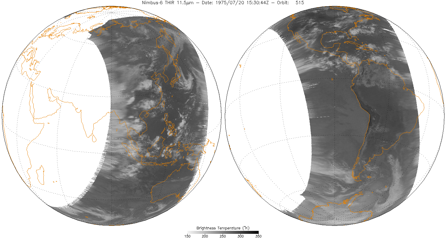
THIR/Nimbus-6 Level 1 Meteorological Radiation Data at 6.7 microns V001 (THIRN6L1CH67) at GES DISC recent views
National Aeronautics and Space Administration —
THIRN6L1CH67 is the Nimbus-6 Temperature-Humidity Infrared Radiometer (THIR) Level 1 Meteorological Radiation Data at 6.7 microns product and contains radiances... -
Federal
BOREAS Regional Soils Data in Raster Format and AEAC Projection recent views
National Aeronautics and Space Administration —
This data set was gridded by BORIS staff from a vector data set received from Canadian Soil Information System (CanSIS). Data were gridded into the Albers Equal-Area... -
Federal
BOREAS TE-21 Daily Surface Meteorological Data recent views
National Aeronautics and Space Administration —
Contains meteorological measurement data collected by TE-21. -
Federal
THIR/Nimbus-5 Level 1 Meteorological Radiation Data at 11.5 microns V001 (THIRN5L1CH115) at GES DISC recent views
National Aeronautics and Space Administration —
THIRN5L1CH115 is the Nimbus-5 Temperature-Humidity Infrared Radiometer (THIR) Level 1 Meteorological Radiation Data at 11.5 microns product and contains radiances... -
Federal
THIR/Nimbus-4 Level 1 Meteorological Radiation Data at 11.5 microns V001 (THIRN4L1CH115) at GES DISC recent views
National Aeronautics and Space Administration —
THIRN4L1CH115 is the Nimbus-4 Temperature-Humidity Infrared Radiometer (THIR) Level 1 Meteorological Radiation Data at 11.5 microns product and contains radiances... -
Federal
BOREAS TGB-12 Soil Carbon and Flux Data of NSA-MSA in Raster Format recent views
National Aeronautics and Space Administration —
This data set contains (1) estimates of soil carbon stocks by horizon based on soil survey data and analyses of data from individual soil profiles; (2) estimates of... -
Federal
THIR/Nimbus-5 Level 1 Meteorological Radiation Data at 6.7 microns V001 (THIRN5L1CH67) at GES DISC recent views
National Aeronautics and Space Administration —
THIRN5L1CH67 is the Nimbus-5 Temperature-Humidity Infrared Radiometer (THIR) Level 1 Meteorological Radiation Data at 6.7 microns product and contains radiances... -
Federal
THIR/Nimbus-4 Level 1 Meteorological Radiation Data at 6.7 microns V001 (THIRN4L1CH67) at GES DISC recent views
National Aeronautics and Space Administration —
THIRN4L1CH67 is the Nimbus-4 Temperature-Humidity Infrared Radiometer (THIR) Level 1 Meteorological Radiation Data at 6.7 microns product contains radiances expressed... -
Federal
THIR/Nimbus-6 Level 1 Meteorological Radiation Data at 11.5 microns V001 (THIRN6L1CH115) at GES DISC recent views
National Aeronautics and Space Administration —
THIRN6L1CH115 is the Nimbus-6 Temperature-Humidity Infrared Radiometer (THIR) Level 1 Meteorological Radiation Data at 11.5 microns product and contains radiances... -
Federal
BOREAS TGB-05 Fire History of Manitoba 1980 to 1991 in Raster Format recent views
National Aeronautics and Space Administration —
Raster format data set covering the province of Manitoba and produced by Forestry Canada from hand-drawn boundaries of fires on photocopies of 1:250,000 scale maps. -
Federal
BOREAS Forest Cover Data Layers Over the SSA-MSA in Raster Format recent views
National Aeronautics and Space Administration —
Raster files created by processing original vector data. Data include information of forest parameters for the BOREAS SSA MSA. -
Federal
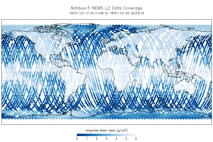
NEMS/Nimbus-5 Level 2 Output Data V001 (NEMSN5L2) at GES DISC recent views
National Aeronautics and Space Administration —
NEMSN5L2 is the Nimbus-5 or Nimbus-E Microwave Spectrometer (NEMS) Level-2 Output Data product and contains surface reflectivity, water vapor, liquid water, layer...

Official websites use .gov
A
.gov website belongs to an official government
organization in the United States.
Secure .gov websites use HTTPS
A
lock (
) or https:// means you’ve safely connected to
the .gov website. Share sensitive information only on official,
secure websites.