
-
Federal
ASTER Global Digital Elevation Model NetCDF V003 NGDA recent views
National Aeronautics and Space Administration —
The ASTER Global Digital Elevation Model (GDEM) Version 3 (ASTGTM) provides a global digital elevation model (DEM) of land areas on Earth at a spatial resolution of 1... -
Federal
Arctic Vegetation Plots at Atqasuk, Alaska, 1975, 2000, and 2010 recent views
National Aeronautics and Space Administration —
This data set provides vegetation species abundance data collected in 1975 from 60 sites on the Arctic Coastal Plain near Atqasuk, Alaska, as well as environmental... -
Federal
ASTER Global Water Bodies Database V001 NGDA recent views
National Aeronautics and Space Administration —
The ASTER Global Water Bodies Database (ASTWBD) Version 1 data product provides global coverage of water bodies larger than 0.2 square kilometers at a spatial... -
Federal
ASTER L2 Surface Reflectance VNIR and Crosstalk Corrected SWIR V003 NGDA recent views
National Aeronautics and Space Administration —
The ASTER Surface Reflectance VNIR and Crosstalk Corrected SWIR (AST_07XT) dataset... -
Federal
ASTER Global Digital Elevation Model Attributes NetCDF V003 NGDA recent views
National Aeronautics and Space Administration —
The ASTER Global Digital Elevation Model (GDEM) Version 3 (ASTGTM) provides a global digital elevation model (DEM) of land areas on Earth at a spatial resolution of 1... -
Federal
ASTER L1A Reconstructed Unprocessed Instrument Data V003 NGDA recent views
National Aeronautics and Space Administration —
The Advanced Spaceborne Thermal Emission and Reflection Radiometer (ASTER) Level 1A (AST_L1A) contains reconstructed, instrument digital numbers (DNs) derived from... -
Federal
Seasonal Antarctic Sea Ice Extent Reconstructions, 1905-2020, Version 1 recent views
National Aeronautics and Space Administration —
These data are reconstructed seasonal Antarctic sea ice extent (SIE) for 1905 through 2020. They are provided along with uncertainty estimates and metadata that... -
Federal
Arctic Vegetation Plots for IBP Tundra Biome, Barrow, Alaska, 1972-2010 recent views
National Aeronautics and Space Administration —
This data set provides vegetation cover and environmental plot data collected as part of the International Biological Program (IBP), U. S. Tundra Biome Program, in... -
Federal
ASTER Orthorectified Digital Elevation Model (DEM) V003 NGDA recent views
National Aeronautics and Space Administration —
The ASTER Digital Elevation Model and Orthorectified Registered Radiance at the Sensor (AST14DMO) product... -
Federal
ASTER Digital Elevation Model V003 NGDA recent views
National Aeronautics and Space Administration —
The ASTER Digital Elevation Model (AST14DEM) product is generated (https://lpdaac.usgs.gov/documents/996/ASTER_Earthdata_Search_Order_Instructions.pdf) using bands 3N... -
Federal
Seasonal frost penetration, Sleepers River Research Watershed, Vermont, USA, Version 1 recent views
National Aeronautics and Space Administration —
The frost tube network is located within a 3.25-square-mile sub-watershed of the Sleepers River Research Watershed near Danville, Vermont, USA. Tubes were positioned... -
Federal
ABoVE: Characterization of Carbon Dynamics in Burned Forest Plots, NWT, Canada, 2014 recent views
National Aeronautics and Space Administration —
This dataset provides field data from boreal forests in the Northwest Territories (NWT), Canada, that were burned by wildfires in 2014. During fieldwork in 2015, 211... -
Federal
ASTER Global Water Bodies Database Attributes NetCDF V001 NGDA recent views
National Aeronautics and Space Administration —
The ASTER Global Water Bodies Database (ASTWBD) Version 1 data product provides global coverage of water bodies larger than 0.2 square kilometers at a spatial... -
Federal
Upper soil temperatures in the Kolyma Highland, Version 1 recent views
National Aeronautics and Space Administration —
This data set contains soil temperature and meteorological data for various sampling locations near the Aborigen research station in the Kolyma Highland, Northeastern... -
Federal
Arctic Vegetation Plots at Umiat, North Slope, Alaska, 1951 recent views
National Aeronautics and Space Administration —
This data set provides vegetation cover and plot data collected during the periods of July and August, 1951, from 51 stands (areas of homogeneous vegetation... -
Federal
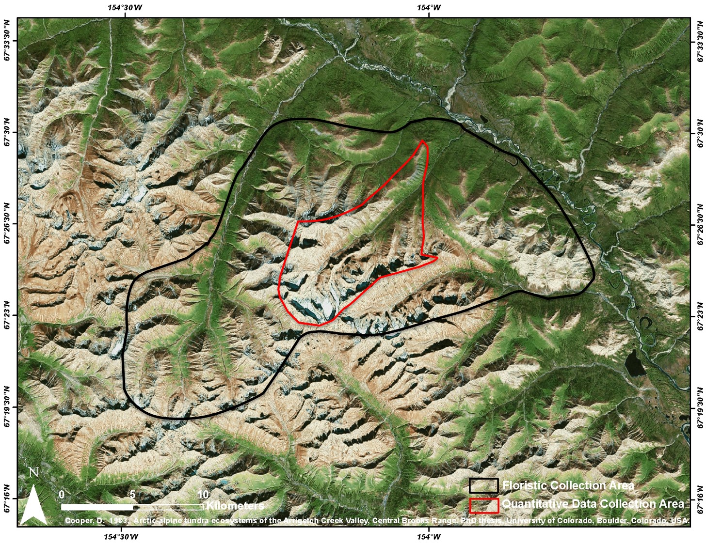
Arctic Vegetation Plots at Arrigetch Peaks, Alaska, 1978-1981 recent views
National Aeronautics and Space Administration —
This data set provides environmental and vegetation data collected between 1978 and 1981 from 439 study plots at Arrigetch Peaks research site, located in the Gates... -
Federal
Arctic Vegetation Plots, Prudhoe Bay ArcSEES Road Study, Lake Colleen, Alaska, 2014 recent views
National Aeronautics and Space Administration —
This dataset provides environmental, soil, and vegetation data collected from study plots in the vicinity of Lake Colleen off the Spine Road at Prudhoe Bay, Alaska,... -
Federal
ABoVE: Synthesis of Burned and Unburned Forest Site Data, AK and Canada, 1983-2016 recent views
National Aeronautics and Space Administration —
This dataset is a synthesis of field plot characterization data, derived above-ground and below-ground combusted carbon, and acquired Fire Weather Index (FWI) System... -
Federal
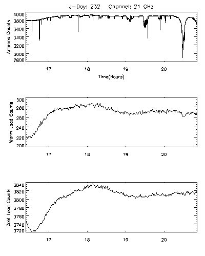
CAMEX-3 DC-8 Airborne Multichannel Microwave Radiometer (AMMR) V1 recent views
National Aeronautics and Space Administration —
The CAMEX-3 DC-8 Airborne Multichannel Microwave Radiometer (AMMR) dataset is a browse-only dataset that consists of plotted digital count measurements collected by... -
Federal
USGS Group on Earth Observations (GEO) Global Agricultural Monitoring (GLAM) Algeria recent views
National Aeronautics and Space Administration —
The objective of GEO is to fulfil a vision of a world where decisions and actions are informed by coordinated, comprehensive and sustained Earth Observation (EO)....

Official websites use .gov
A
.gov website belongs to an official government
organization in the United States.
Secure .gov websites use HTTPS
A
lock (
) or https:// means you’ve safely connected to
the .gov website. Share sensitive information only on official,
secure websites.