
-
Federal
NACP North American Forest Dynamics Project: Forest Disturbance and Regrowth Data recent views
National Aeronautics and Space Administration —
This data set provides the results of time-series analyses of Landsat imagery for 55 selected forested sites across the conterminous U.S.A. The output is a pair of... -
Federal
GEWEX SRB Integrated Product (Rel-4) Longwave Monthly Average by UTC Ocean-only Fluxes recent views
National Aeronautics and Space Administration —
GEWEXSRB_Rel4-IP_Longwave_monthly_oceanonly_utc is the Global Energy and Water Exchanges (GEWEX) Surface Radiation Budget (SRB) Integrated Product (Rel-4) Longwave... -
Federal
LiDAR Surveys over Selected Forest Research Sites, Brazilian Amazon, 2008-2018 recent views
National Aeronautics and Space Administration —
This dataset provides the complete catalog of point cloud data collected during LiDAR surveys over selected forest research sites across the Amazon rainforest in... -
Federal
GLDAS Catchment Land Surface Model L4 daily 0.25 x 0.25 degree GRACE-DA1 V2.2 (GLDAS_CLSM025_DA1_D) at GES DISC recent views
National Aeronautics and Space Administration —
NASA Global Land Data Assimilation System Version 2 (GLDAS-2) has three components: GLDAS-2.0, GLDAS-2.1, and GLDAS-2.2. GLDAS-2.0 is forced entirely with the... -
Federal
Sentinel-5P TROPOMI Total Ozone Column 1-Orbit L2 7km x 3.5km V1 (S5P_L2__O3_TOT) at GES DISC recent views
National Aeronautics and Space Administration —
Starting from August 6th in 2019, Sentinel-5P TROPOMI along-track high spatial resolution (~5.5km at nadir) has been implemented. Starting from July 13th in 2020,... -
Federal
SWOT Level 2 Water Mask Pixel Cloud Auxiliary Data Product, Version 1.1 recent views
National Aeronautics and Space Administration —
Auxiliary information for pixel cloud product indicating to which water bodies the pixels are assigned in river and lake products. Also includes height-constrained... -
Federal
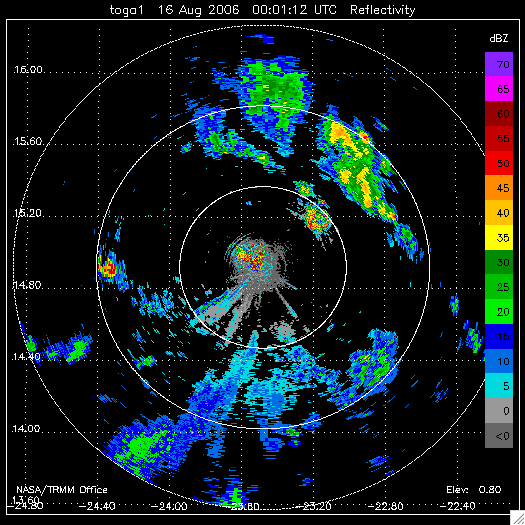
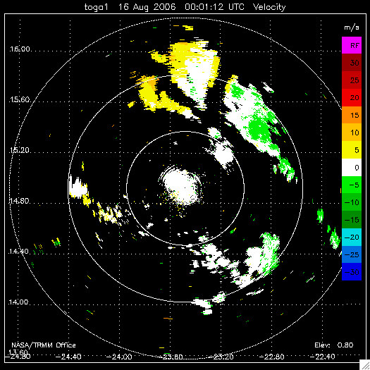
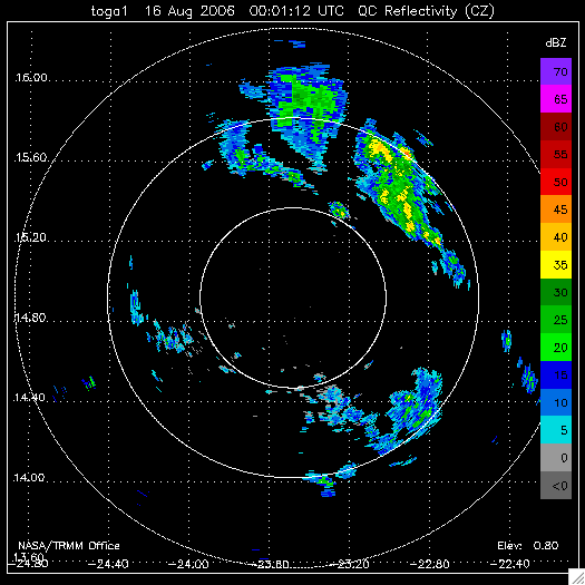
NAMMA TOGA RADAR DATA V1 recent views
National Aeronautics and Space Administration —
The NAMMA TOGA Radar Data dataset consists of a collection of products derived from the NASA TOGA radar observations that were collected in the Republic of Cape Verde... -
Federal
GPM Ground Validation Environment Canada (EC) Visibility Sensor FD12P C3VP V1 recent views
National Aeronautics and Space Administration —
The GPM Ground Validation (GV) Environment Canada (EC) Visibility Sensor FD12P C3VP dataset consists of visibility and precipitation data collected at the Environment... -
Federal
Earth Radiation Budget Experiment (ERBE) S-10 Medium Field of View (MFOV) Shape Factor (SF) Radiant Flux and Albedo recent views
National Aeronautics and Space Administration —
ERBE_S10_MFOV_SF_NAT_1 is the Earth Radiation Budget Experiment (ERBE) S-10 Medium Field of View (MFOV) Shape Factor (SF) Radiant Flux and Albedo data product. Data... -
Federal
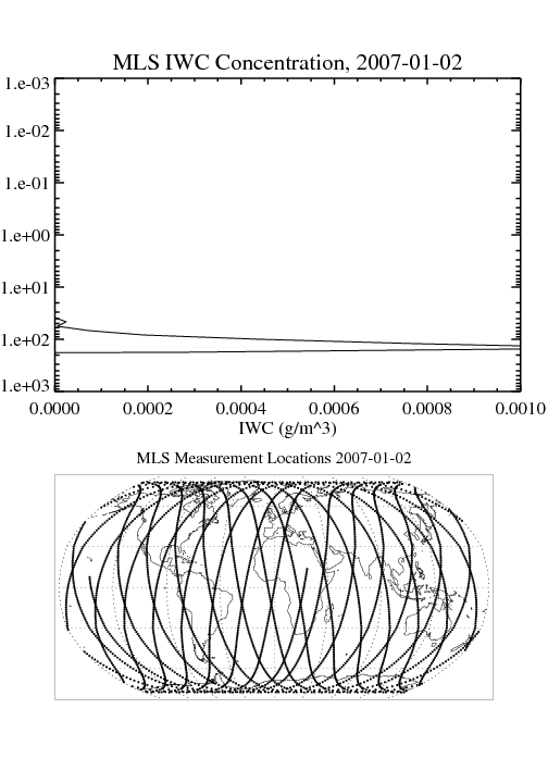
MLS/Aura Level 2 Cloud Ice Product V004 (ML2IWC) at GES DISC recent views
National Aeronautics and Space Administration —
ML2IWC is the EOS Aura Microwave Limb Sounder (MLS) standard product for cloud ice water content derived from radiances measured by the 240 GHz radiometer. The data... -
Federal
GHRSST NOAA/STAR GOES-17 ABI L3C America Region SST v2.71 dataset in GDS2 recent views
National Aeronautics and Space Administration —
The ACSPO G17/ABI L3C (Level 3 Collated) product is a gridded version of the ACSPO G17/ABI L2P product available at... -
Federal
GPM ATMS on NOAA-21 (GPROF) Climate-based Radiometer Precipitation Profiling L3 1 day 0.25 degree x 0.25 degree V07 (GPM_3GPROFNOAA21ATMS_DAY_CLIM) at GES DISC recent views
National Aeronautics and Space Administration —
Version 07 is the current version of the data set. Older versions are no longer available and have been superseded by Version 07. The "CLIM" products differ from... -
Federal
TES/Aura L3 Atmospheric Temperatures Monthly Gridded V005 recent views
National Aeronautics and Space Administration —
TL3ATM_5 is the Tropospheric Emission Spectrometer (TES)/Aura Level 2 Atmospheric Temperatures Limb Version 5 data product. TES was an instrument aboard NASA's Aura... -
Federal
TROPESS AIRS-Aqua L2 Methane for Forward Stream, Standard Product V1 (TRPSDL2CH4AIRSFS) at GES DISC recent views
National Aeronautics and Space Administration —
The TROPESS AIRS-Aqua L2 Methane for Forward Stream, Standard Product contains the vertical distribution of the retrieved atmospheric state of methane (CH4), formal... -
Federal
Aquarius Official Release Level 3 Sea Surface Salinity Standard Mapped Image Descending Daily Data V5.0 recent views
National Aeronautics and Space Administration —
Aquarius Level 3 sea surface salinity (SSS) standard mapped image data contains gridded 1 degree spatial resolution SSS averaged over daily, 7 day, monthly, and... -
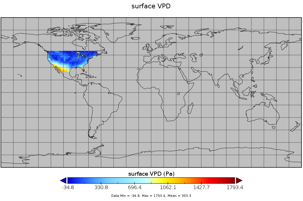
Federal
Spatial Statistical Data Fusion (SSDF) Level 3: CONUS Near-Surface Vapor Pressure Deficit from SNPP CrIMSS and Aqua AIRS, V2 (SNDR13IML3SSDFCVPD) recent views
National Aeronautics and Space Administration —
The Spatial Statistical Data Fusion (SSDF) surface continental United States (CONUS) products, fuse data from the Atmospheric InfraRed Sounder (AIRS) instrument on... -
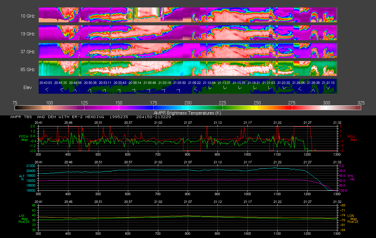
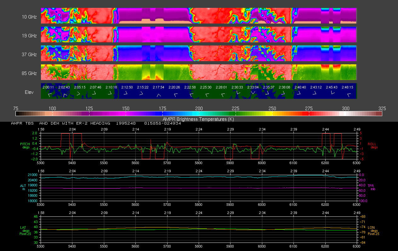
Federal
AMPR BRIGHTNESS TEMPERATURE CAMEX-2 V2 recent views
National Aeronautics and Space Administration —
The Advanced Microwave Precipitation Radiometer (AMPR) was deployed during the Convection and Moisture Experiment 2 (CAMEX-2). AMPR data were collected at a... -
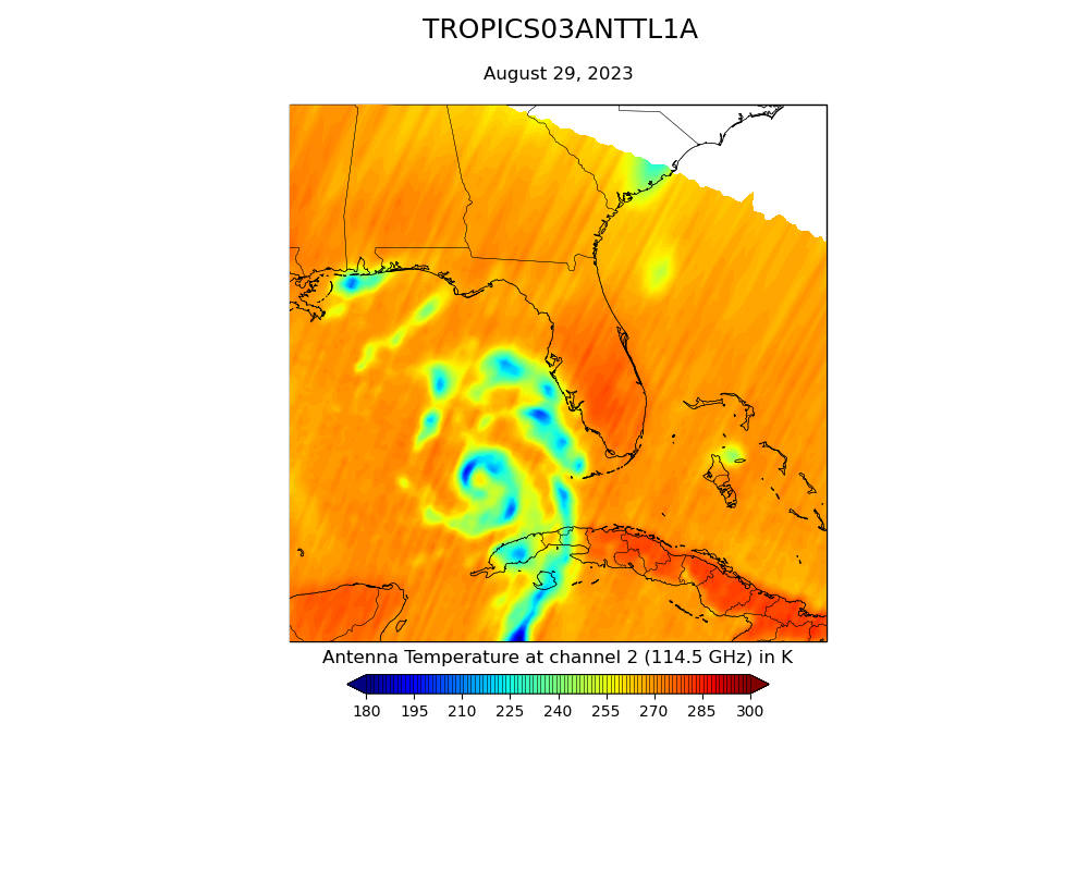
Federal
TROPICS03 L1A Orbital Geolocated Native-Resolution Antenna Temperatures V0.2 recent views
National Aeronautics and Space Administration —
The "Time-Resolved Observations of Precipitation structure and storm Intensity with a Constellation of Smallsats" (TROPICS) mission has a goal of providing nearly... -
Federal
OMPS-NPP L1G LP Radiance EV Wavelength-Altitude Grid swath orbital 3slit V2.6 (OMPS_NPP_LP_L1G_EV) at GES DISC recent views
National Aeronautics and Space Administration —
The OMPS-NPP L1G LP Radiance EV Wavelength-Altitude Grid swath orbital 3slit product contains the calibrated earth-viewing radiances measured by the Ozone Mapping and... -
Federal
MERRA-2 statD_2d_slv_Nx: 2d,Daily,Aggregated Statistics,Single-Level,Assimilation,Single-Level Diagnostics 0.625 x 0.5 degree V5.12.4 (M2SDNXSLV) at GES DISC recent views
National Aeronautics and Space Administration —
M2SDNXSLV (or statD_2d_slv_Nx) is a 2-dimensional daily data collection in Modern-Era Retrospective analysis for Research and Applications version 2 (MERRA-2). This...

Official websites use .gov
A
.gov website belongs to an official government
organization in the United States.
Secure .gov websites use HTTPS
A
lock (
) or https:// means you’ve safely connected to
the .gov website. Share sensitive information only on official,
secure websites.