
-
Federal
CALIPSO Lidar Level 2 Cloud Profile, V4-20 15 recent views
National Aeronautics and Space Administration —
CAL_LID_L2_05kmCPro-Standard-V4-20 is the Cloud-Aerosol Lidar and Infrared Pathfinder Satellite Observations (CALIPSO) Lidar Level 2 Cloud Profile, Version 4-20 data... -
Federal
CALIPSO Lidar Level 2 Aerosol Profile, V4-20
National Aeronautics and Space Administration —
CAL_LID_L2_05kmAPro-Standard-V4-20 is the Cloud-Aerosol Lidar and Infrared Pathfinder Satellite Observations (CALIPSO) Lidar Level 2 Aerosol Profile, Version 4-20... -
Federal
CALIPSO Lidar Level 2 Vertical Feature Mask (VFM), V4-20
National Aeronautics and Space Administration —
CAL_LID_L2_VFM-Standard-V4-20 is the Cloud-Aerosol Lidar and Infrared Pathfinder Satellite Observations (CALIPSO) Lidar Level 2 Vertical Feature Mask (VFM), Version... -
Federal
Polar Winds II - Doppler Aerosol WiNd (DAWN) - DC8
National Aeronautics and Space Administration —
PolarWindsII_DAWN_DC8_1 is the Polar Winds II - Doppler Aerosol WiNd (DAWN) - DC8 data product. Data collection for this product is complete. Beginning in the fall of... -
Federal
LiDAR Surveys over Selected Forest Research Sites, Brazilian Amazon, 2008-2018
National Aeronautics and Space Administration —
This dataset provides the complete catalog of point cloud data collected during LiDAR surveys over selected forest research sites across the Amazon rainforest in... -
Federal
CALIPSO Lidar Level 2 1/3km Cloud Layer data, Validated Stage 1 V3-30
National Aeronautics and Space Administration —
CAL_LID_L2_333mCLay-ValStage1-V3-30 data are Cloud-Aerosol Lidar and Infrared Pathfinder Satellite Observation (CALIPSO) Lidar Level 2 1/3km (333m) cloud layer data,... -
Federal
CALIPSO Lidar Level 2 5 km Merged Layer, V4-20
National Aeronautics and Space Administration —
CAL_LID_L2_05kmMLay-Standard-V4-20 is the Cloud-Aerosol Lidar and Infrared Pathfinder Satellite Observations (CALIPSO) Lidar Level 2 5 km Merged Layer, Version 4-20... -
Federal
SnowEx23 Bonanza Creek Experimental Forest Terrestrial Lidar Scans Raw V001
National Aeronautics and Space Administration —
This data set contains unprocessed point cloud data created from terrestrial lidar scans (TLS) collected during the SnowEx 2023 campaign from the Bonanza Creek... -
Federal
ABoVE/ASCENDS: Atmospheric Backscattering Coefficient Profiles from CO2 Sounder, 2017
National Aeronautics and Space Administration —
This dataset provides atmospheric backscattering coefficient profiles collected during Active Sensing of CO2 Emissions over Nights, Days, and Seasons (ASCENDS)... -
Federal
CMS: LiDAR Data for Forested Areas in Paragominas, Para, Brazil, 2012-2014
National Aeronautics and Space Administration —
This data set provides raw LiDAR point cloud data and derived Digital Terrain Models (DTMs) for five forested areas in the municipality of Paragominas, Para, Brazil,... -
Federal
CALIPSO Lidar Level 1B profile data, V4-11
National Aeronautics and Space Administration —
CAL_LID_L1-Standard-V4-11 is the Cloud-Aerosol Lidar and Infrared Pathfinder Satellite Observation (CALIPSO) Lidar Level 1B profile data, Version 4-10 data product.... -
Federal
CALIPSO Lidar Level 2 5 km Merged Layer, V4-21
National Aeronautics and Space Administration —
CAL_LID_L2_05kmMLay-Standard-V4-21 is the Cloud-Aerosol Lidar and Infrared Pathfinder Satellite Observations (CALIPSO) Lidar Level 2 5 km Merged Layer, Version 4-21... -
Federal
CALIPSO Night Validation Flights High Spectral Resolution Lidar (HSRL-2) Data
National Aeronautics and Space Administration —
The CALIPSO Night Validation Flights (CALIPSO-NVF) airborne deployment was conducted in August 2022 out of Bermuda. The goal was to conduct a series of nighttime... -
Federal
CALIPSO Lidar Level 2 5 km Aerosol Layer Data, V4-20
National Aeronautics and Space Administration —
CAL_LID_L2_05kmALay-Standard-V4-20 is the Cloud-Aerosol Lidar and Infrared Pathfinder Satellite Observation (CALIPSO) Lidar Level 2 5 km Aerosol Layer Data, Version... -
Federal
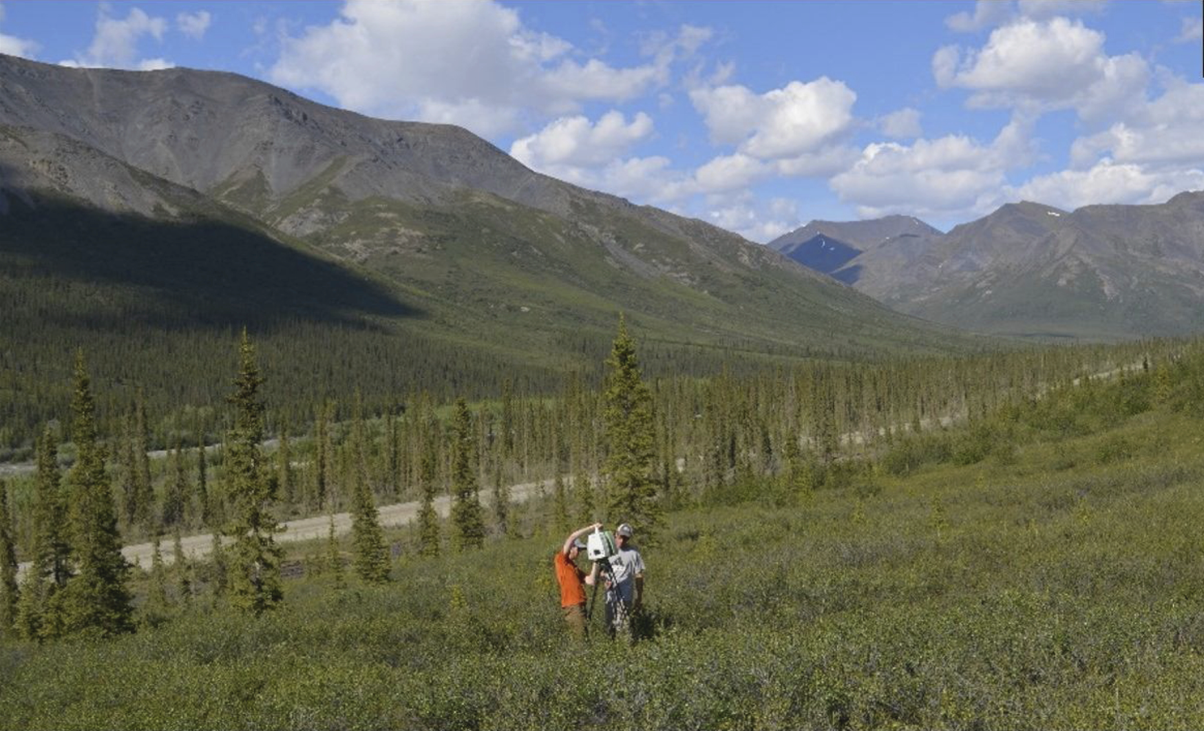
ABoVE: Terrestrial Lidar Scanning Forest-Tundra Ecotone, Brooks Range, Alaska, 2016
National Aeronautics and Space Administration —
This dataset provides terrestrial lidar scanning (TLS) point cloud data collected at 10 research plots along the forest-tundra ecotone (FTE) in the Brooks Range of... -
Federal
CALIPSO Lidar Level 1B profile data, V4-51
National Aeronautics and Space Administration —
CAL_LID_L1-Standard-V4-51 is the Cloud-Aerosol Lidar and Infrared Pathfinder Satellite Observation (CALIPSO) Lidar Level 1B profile data, Version 4-51 data product.... -
Federal
CALIPSO Lidar Level 2 5km Aerosol Profile data, Provisional V3-02
National Aeronautics and Space Administration —
CAL_LID_L2_05kmAPro-Prov-V3-02 data are Cloud-Aerosol Lidar and Infrared Pathfinder Satellite Observation (CALIPSO) Lidar Level 2 aerosol profile data using the... -
Federal
GEDI L2A Elevation and Height Metrics Data Global Footprint Level V002
National Aeronautics and Space Administration —
The Global Ecosystem Dynamics Investigation (GEDI) mission aims to characterize ecosystem structure and dynamics to enable radically improved quantification and... -
Federal
SnowEx17 Boise State University Raw Terrestrial Laser Scanner (TLS) Point Cloud V001
National Aeronautics and Space Administration —
This data set contains raw, unprocessed terrestrial laser scanner (TLS) point cloud data collected as part of the 2017 SnowEx campaign in Grand Mesa, Colorado. Data... -
Federal
DISCOVER-AQ California Deployment Huron Ground Site Data
National Aeronautics and Space Administration —
DISCOVERAQ_California_Ground_Huron_Data contains data collected at the Huron ground site during the California (San Joaquin Valley) deployment of NASA's DISCOVER-AQ...

Official websites use .gov
A
.gov website belongs to an official government
organization in the United States.
Secure .gov websites use HTTPS
A
lock (
) or https:// means you’ve safely connected to
the .gov website. Share sensitive information only on official,
secure websites.