
-
Federal
GPM IMERG Final Precipitation L3 1 day 0.1 degree x 0.1 degree V07 (GPM_3IMERGDF) at GES DISC
National Aeronautics and Space Administration —
Version 07 is the current version of the data set. Older versions will no longer be available and have been superseded by Version 07.The Integrated Multi-satellitE... -
Federal
OCO-2 Level 2 geolocated XCO2 retrievals results, physical model V11.2 (OCO2_L2_Standard) at GES DISC
National Aeronautics and Space Administration —
Version 11.2 is the current version of the data set. Older versions will no longer be available and are superseded by Version 11.2. The Orbiting Carbon Observatory is... -
Federal
Daymet: Daily Surface Weather Data on a 1-km Grid for North America, Version 4 R1
National Aeronautics and Space Administration —
This dataset provides Daymet Version 4 R1 data as gridded estimates of daily weather parameters for North America, Hawaii, and Puerto Rico. Daymet variables include... -
Federal
UARS Improved Stratospheric and Mesospheric Sounder (ISAMS) Level 3AL V010 (UARIS3AL) at GES DISC
National Aeronautics and Space Administration —
The Improved Stratospheric and Mesospheric Sounder (ISAMS) Level 3AL data product consists of daily, 4 degree increment latitude-ordered vertical profiles of... -
Federal
NACP Site: Terrestrial Biosphere Model Output Data in Original Format
National Aeronautics and Space Administration —
This data set contains the original model output data submissions from the 24 terrestrial biosphere models (TBM) that participated in the North American Carbon... -
Federal
HAQAST Sentinel-5P TROPOMI Nitrogen Dioxide (NO2) GLOBAL Monthly Level 3 0.1 x 0.1 Degree Gridded Data Version 2.4 (HAQ_TROPOMI_NO2_GLOBAL_M_L3) at GES DISC
National Aeronautics and Space Administration —
This product provides level 3 monthly averages of tropospheric Nitrogen dioxide (NO2) vertical column density derived from the level 2 Tropospheric Monitoring... -
Federal
NACP Aboveground Biomass and Carbon Baseline Data, V.2 (NBCD 2000), U.S.A., 2000
National Aeronautics and Space Administration —
The NBCD 2000 (National Biomass and Carbon Dataset for the Year 2000) data set provides a high-resolution (30 m) map of year-2000 baseline estimates of basal area-... -
Federal
ECOSTRESS Gridded Downscaled Meteorology Instantaneous L3 Global 70 m V002
National Aeronautics and Space Administration —
The ECOsystem Spaceborne Thermal Radiometer Experiment on Space Station (ECOSTRESS) mission measures the temperature of plants to better understand how much water... -
Federal
CERES Single Scanner Footprint (SSF) TOA/Surface Fluxes, Clouds and Aerosols Terra-FM1 Edition4A
National Aeronautics and Space Administration —
CER_SSF_Terra-FM1-MODIS_Edition4A is the Clouds and the Earth's Radiant Energy System (CERES) Single Scanner Footprint (SSF) Top-of-the-Atmosphere (TOA)/Surface... -
Federal
GEDI L2A Elevation and Height Metrics Data Global Footprint Level V002
National Aeronautics and Space Administration —
The Global Ecosystem Dynamics Investigation (GEDI) mission aims to characterize ecosystem structure and dynamics to enable radically improved quantification and... -
Federal
GEOS-Carb CASA-GFED Daily Fire and Fuel Emissions 0.5 degree x 0.5 degree V3 (GEOS_CASAGFED_D_FIRE) at GES DISC
National Aeronautics and Space Administration —
This product provides Daily average wildfire emissions (FIRE) andfuel wood burning emissions (FUEL) derived from the Carnegie-Ames-Stanford-Approach – Global Fire... -
Federal
UARS Cryogenic Limb Array Etalon Spectrometer (CLAES) Level 3AL V009 (UARCL3AL) at GES DISC
National Aeronautics and Space Administration —
The Cryogenic Limb Array Etalon Spectrometer (CLAES) Level 3AL data product consists of daily, 4 degree increment latitude-ordered vertical profiles of temperature... -
Federal
GPM IMERG Early Precipitation L3 1 day 0.1 degree x 0.1 degree V07 (GPM_3IMERGDE) at GES DISC
National Aeronautics and Space Administration —
Version 07 is the current version of the data set. Older versions will no longer be available and have been superseded by Version 07.The Integrated Multi-satellitE... -
Federal
GPM SSMIS on F16 (GPROF) Radiometer Precipitation Profiling L2 1.5 hours 12 km V07 (GPM_2AGPROFF16SSMIS) at GES DISC
National Aeronautics and Space Administration —
Version 07 is the current version of the data set. Older versions will no longer be available and have been superseded by Version 07.The 2AGPROF (Goddard Profiling)... -
Federal
IRIS/Nimbus-4 Level 1 Radiance Data V001 (IRISN4RAD) at GES DISC
National Aeronautics and Space Administration —
The Nimbus-4 Infrared Interferometer Spectrometer (IRIS) Level 1 Radiance Data contain thermal emissions of the Earth's atmosphere at wave numbers between 400 and... -
Federal
SBUV2/NOAA-18 Ozone (O3) Profile and Total Column Ozone 1 Month Zonal Mean L3 Global 5.0 degree Latitude Zones V1 (SBUV2N18L3zm) at GES DISC
National Aeronautics and Space Administration —
The Solar Backscattered Ultraviolet (SBUV) from NOAA-18 Level-3 monthly zonal mean (MZM) product (SBUV2N18L3zm) is derived from the Level-2 retrieved ozone profiles.... -
Federal
Sentinel-5P TROPOMI Total Ozone Column 1-Orbit L2 7km x 3.5km V1 (S5P_L2__O3_TOT) at GES DISC
National Aeronautics and Space Administration —
Starting from August 6th in 2019, Sentinel-5P TROPOMI along-track high spatial resolution (~5.5km at nadir) has been implemented. Starting from July 13th in 2020,... -
Federal
WRF-STILT Particle Trajectories for Boston, MA, USA, 2013-2014
National Aeronautics and Space Administration —
This dataset provides Weather Research and Forecasting (WRF) Stochastic Time-Inverted Lagrangian Transport (STILT) particle trajectory data and footprint products for... -
Federal
TRMM Precipitation Radar Rain Characteristics L2 1.5 hours V7 (TRMM_2A23) at GES DISC
National Aeronautics and Space Administration —
The new version of these data is in GPM-like format (consistent with the GPM Dual-frequency Radar data format), and can be found under the name GPM_2APR. The TRMM... -
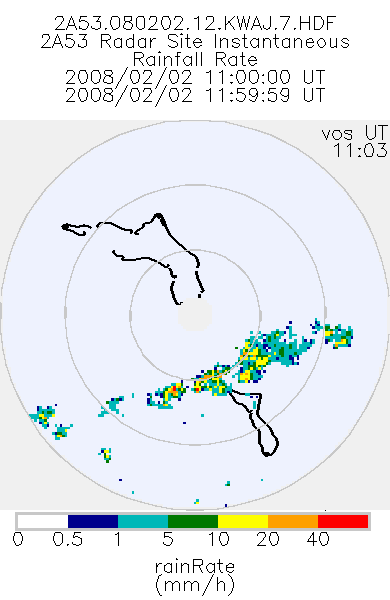
Federal
TRMM Ground Validation Radar Site Rain Rate Map L2 1 hour 2 km V7 (TRMM_2A53UW) at GES DISC
National Aeronautics and Space Administration —
This dataset is part of the University of Washington TRMM Ground Validation products. Instantaneous rain rate cartesian grid based on baseUW and 2A54UW. Units are...

Official websites use .gov
A
.gov website belongs to an official government
organization in the United States.
Secure .gov websites use HTTPS
A
lock (
) or https:// means you’ve safely connected to
the .gov website. Share sensitive information only on official,
secure websites.