
-
Federal
Sparse Inverse Gaussian Process Regression with Application to Climate Network Discovery
National Aeronautics and Space Administration —
Regression problems on massive data sets are ubiquitous in many application domains including the Internet, earth and space sciences, and finances. Gaussian Process... -
Federal
ROSETTA-ORBITER 67P NAVCAM 2 ROSETTA EXTENSION 3 MTP035 V1.0
National Aeronautics and Space Administration —
This dataset contains ROSETTA NAVCAM RAW DATA of the Ext3 Phase from 26th Sep 2016 to 30th Sep 2016 when at the vicinity of target 67P/CG. 30th Sep 2016 is the end of... -
Federal
SMASS ASTEROID SURVEY V2.1
National Aeronautics and Space Administration —
Small Main-Belt Asteroid Spectrographic Survey over the visual range. -
Federal
High Mountain Asia GFDL FLOR Modeled Extreme Precipitation Indices V001
National Aeronautics and Space Administration —
This data set features seven standard annual mean extreme precipitation indices: Rx1day, Rx5day, CWD, R10mm, R20mm, R95pTOT, and R99pTOT. They were selected on the... -
Federal
MISR Level 2 TOA/Cloud Aerosol Product subset for the GoMACCS region V002
National Aeronautics and Space Administration —
GOMI2AE_002 is the Multi-angle Imaging SpectroRadiometer (MISR) Level 2 TOA/Cloud-Aerosol Product subset for the GoMACCS region version 2. It contains Aerosol optical... -
Federal
Soil Reflectance Data (FIFE)
National Aeronautics and Space Administration —
Soil reflectance properties are an important factor in determining landscape reflectance characteristics. No soil reflectance data were collected as part of the FIFE... -
Federal
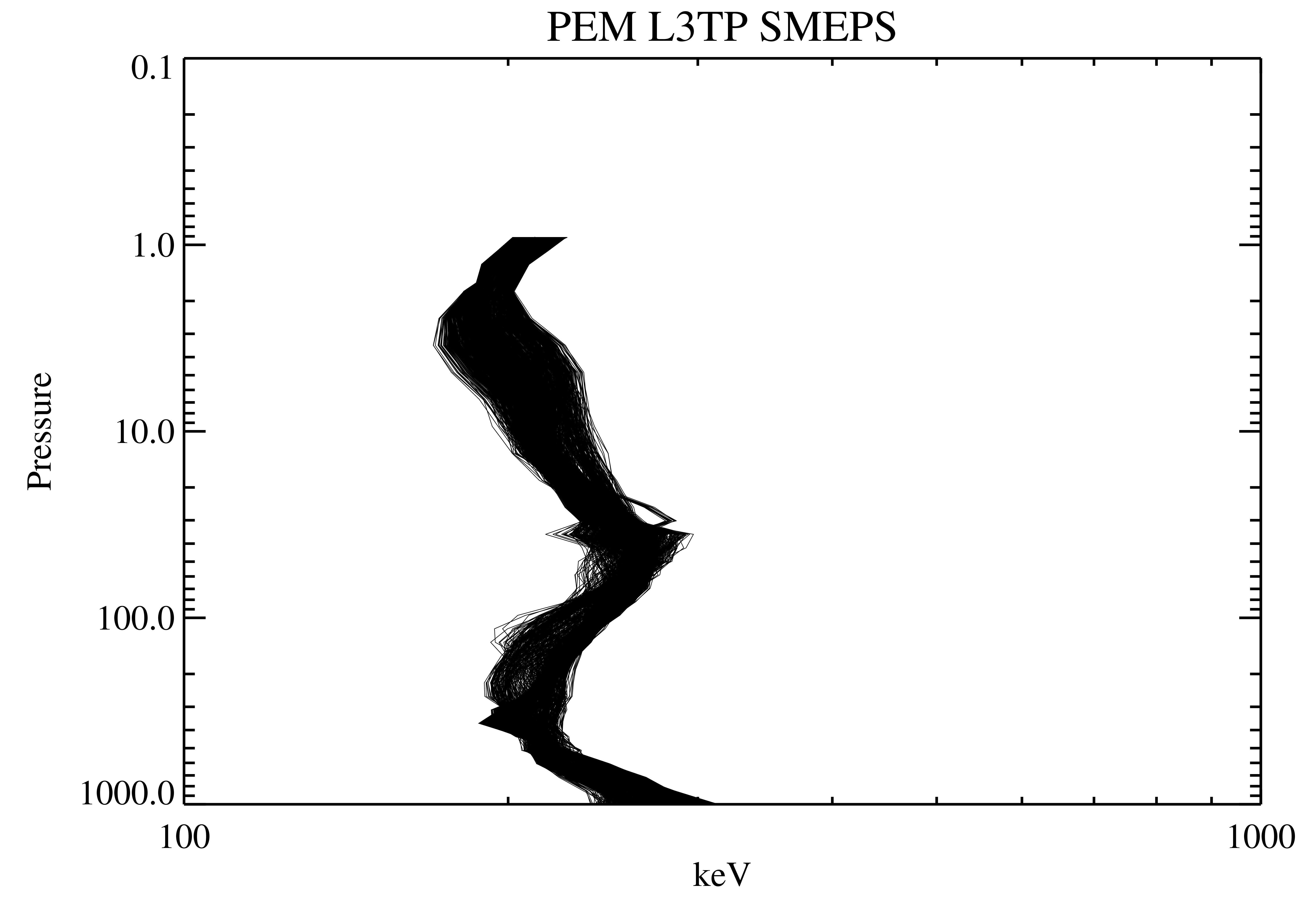
UARS PEM Level 2 MEPS V001 (UARPE2MEPS) at GES DISC
National Aeronautics and Space Administration —
The Particle Environment Monitor (PEM) level 2 Medium-Energy Particle Spectrometer (MEPS) daily product contains the electron and proton high-resolution spectral data... -
Federal
ROSETTA-ORBITER 67P NAVCAM 2 PRELANDING MTP006 V1.0
National Aeronautics and Space Administration —
This dataset contains ROSETTA NAVCAM RAW DATA of the Prelanding Phase from 1st Aug 2014 to 2nd Sep 2014 before reaching target 67P/CG. -
Federal
MSL MARS CHEMISTRY AND MINERALOGY 5 RDR V1.0
National Aeronautics and Space Administration —
The CheMin instrument determines the mineralogy and elemental composition of powdered samples through the combined application of X-ray diffraction (XRD, producing... -
Federal
VG2 JUP RADIO ASTRONOMY REDUCED 6SEC V1.0
National Aeronautics and Space Administration —
VG2-J-PRA-3-RDR-6SEC-V1.0 -
Federal
ROSETTA-LANDER EARTH ROMAP 3 EAR2 MAG V1.0
National Aeronautics and Space Administration —
This archive contains level 3 data from the ROMAP-MAG instrument onboard ROSETTA Lander, acquired during the EAR2 (Earth fly-by 2) phase. It also contains... -
Federal
ROSETTA-ORBITER CHECKOUT OSIWAC 4 CVP2 RDR-STRLIGHT V1.0
National Aeronautics and Space Administration —
This CODMAC level 4 data set contains solar stray light corrected, radiometric calibrated and geometric distortion corrected (resampled) image data in W/m^2/sr/nm,... -
Federal
TOVS LMD MONTHLY GRIDS from NOAA-10 V01 (TOVSBMNG) at GES DISC
National Aeronautics and Space Administration —
Level 3 parameters from HIRS/2 and MSU radiances using the Improved Initialization Inversion (3I) classification retrieval scheme by the Laboratoire de Meteorologie... -
Federal
Chandra Point Sources in 18 Distant Galaxy Clusters
National Aeronautics and Space Administration —
With the superb angular resolution of the Chandra Observatory, it is now possible to detect X-ray point sources, either embedded in galaxy clusters or along the... -
Federal
Arctic Vegetation Plots on Unalaska Island, Aleutian Islands, Alaska, 2007
National Aeronautics and Space Administration —
This data set provides environmental, soil, and vegetation data collected during August 2007 from 69 study plots at the Unalaska Island research site, and one plot on... -
Federal
ECCO Sea Surface Height - Daily Mean llc90 Grid (Version 4 Release 4)
National Aeronautics and Space Administration —
This dataset provides daily-averaged dynamic sea surface height and model sea level anomaly on the native Lat-Lon-Cap 90 (LLC90) model grid from the ECCO Version 4...

Official websites use .gov
A
.gov website belongs to an official government
organization in the United States.
Secure .gov websites use HTTPS
A
lock (
) or https:// means you’ve safely connected to
the .gov website. Share sensitive information only on official,
secure websites.