
-
Federal
Environmentally Responsible Aviation Project
National Aeronautics and Space Administration —
Created in 2009 as part of NASA's Aeronautics Research Mission Directorate's Integrated Systems Research Program, the Environmentally Responsible Aviation... -
Federal
ASTER Global Digital Elevation Model V003
National Aeronautics and Space Administration —
The Terra Advanced Spaceborne Thermal Emission and Reflection Radiometer (ASTER) Global Digital Elevation Model (GDEM) Version 3 (ASTGTM) provides a global digital... -
Federal
China Dimensions Data Collection: China County-Level Data on Population (Census) and Agriculture, Keyed to 1:1M GIS Map
National Aeronautics and Space Administration —
The China County-Level Data on Population (Census) and Agriculture, Keyed To 1:1M GIS Map consists of census, agricultural economic, and boundary data for the... -
Federal
SDG Indicator 9.1.1: Rural Access Index (RAI), 2023 Release
National Aeronautics and Space Administration —
The SDG Indicator 9.1.1: The Rural Access Index (RAI), 2023 Release data set, part of the SDGI collection, measures the proportion of the rural population who live... -
Federal
Global Fertilizer and Manure, Version 1: Nitrogen Fertilizer Application
National Aeronautics and Space Administration —
The Nitrogen Fertilizer Application data set of the Global Fertilizer and Manure, Version 1 Data Collection represents the amount of nitrogen fertilizer nutrients... -
Federal
China Dimensions Data Collection: China County-Level Data from Provincial Economic Yearbooks, Keyed to 1:1M GIS Map
National Aeronautics and Space Administration —
The China County-Level Data on Provincial Economic Yearbooks, Keyed To 1:1M GIS Map consists of socioeconomic and boundary data for the administrative regions of... -
Federal
Multiple Kernel Learning for Heterogeneous Anomaly Detection: Algorithm and Aviation Safety Case Study
National Aeronautics and Space Administration —
The world-wide aviation system is one of the most complex dynamical systems ever developed and is generating data at an extremely rapid rate. Most modern commercial... -
Federal
Identification of Spatial Fault Patterns in Semiconductor Wafers
National Aeronautics and Space Administration —
Abstract The semiconductor industry is constantly searching for new ways to increase the rate of both process development and yield learning. As more data is being... -
Federal
Solving a prisoner's dilemma in distributed anomaly detection
National Aeronautics and Space Administration —
Anomaly detection has recently become an important problem in many industrial and financial applications. In several instances, the data to be analyzed for possible... -
Federal
ASTER Global Digital Elevation Model NetCDF V003
National Aeronautics and Space Administration —
The Terra Advanced Spaceborne Thermal Emission and Reflection Radiometer (ASTER) Global Digital Elevation Model (GDEM) Version 3 (ASTGTM) provides a global digital... -
Federal
A Reasoning Architecture for Expert Troubleshooting of Complex Processes
National Aeronautics and Space Administration —
This paper introduces a novel reasoning methodology, in combination with appropriate models and measurements (data) to perform accurately and expeditiously expert... -
Federal
Meteorology and soil temperatures, Hot Weather Creek, Ellesmere Island, NWT, Canada, Version 1
National Aeronautics and Space Administration —
The instrumentation was installed in June 1988 and was initially maintained by the Arctic Adaptation Division Canadian Climate Centre, Atmospheric Environment Service... -
Federal
AVHRR 1-km Global Land 10-Day Composites
National Aeronautics and Space Administration —
The Advanced Very High Resolution Radiometer (AVHRR) 1-km Global Land 10-Day Composites data set project is a component of the National Aeronautics and Space... -
Federal
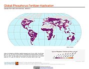
Global Fertilizer and Manure, Version 1: Phosphorus Fertilizer Application
National Aeronautics and Space Administration —
The Phosphorus Fertilizer Application data set of the Global Fertilizer and Manure, Version 1 Data Collection represents the amount of phosphorus fertilizer nutrients... -
Federal
NARSTO EPA Supersite (SS) Baltimore, Rapid Single-Particle Mass Spectrometer (RSMS) Data
National Aeronautics and Space Administration —
NARSTO_EPA_SS_BALTIMORE_RAPID_SPMS_DATA is the North American Research Strategy for Tropospheric Ozone (NARSTO) Environmental Protection Agency (EPA) Supersite (SS)... -
Federal
Vulcan: High-Resolution Hourly Fossil Fuel CO2 Emissions in USA, 2010-2015, Version 3
National Aeronautics and Space Administration —
The Vulcan version 3.0 hourly dataset quantifies hourly emissions at a 1-km resolution for the 2010-2015 time period. Estimates are provided of hourly carbon dioxide... -
Federal
GPM GROUND VALIDATION DUAL-FREQUENCY DUAL-POLARIZED DOPPLER RADAR (D3R) GCPEX V1
National Aeronautics and Space Administration —
The GPM Ground Validation Dual-frequency Dual-polarized Doppler Radar (D3R) GCPEx and IFloodS data sets contain radar reflectivity and doppler velocity measurements.... -
Federal
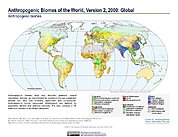
Anthropogenic Biomes of the World, Version 2: 2000
National Aeronautics and Space Administration —
The Anthropogenic Biomes of the World, Version 2: 2000 data set describes anthropogenic transformations within the terrestrial biosphere caused by sustained direct... -
Federal
Accelerated Aging Experiments for Prognostics of Damage Growth in Composite Materials
National Aeronautics and Space Administration —
Composite structures are gaining importance for use in the aerospace industry. Compared to metallic structures their behavior is less well understood. This lack of...

Official websites use .gov
A
.gov website belongs to an official government
organization in the United States.
Secure .gov websites use HTTPS
A
lock (
) or https:// means you’ve safely connected to
the .gov website. Share sensitive information only on official,
secure websites.