
-
Federal
M2-SCREAM: 3d,3-Hourly,Instantaneous,Model-Level,Assimilation,Assimilated Constituent Fields,Replayed MERRA-2 Meteorological Fields
National Aeronautics and Space Administration —
The MERRA-2 Stratospheric Composition Reanalysis of Aura MLS (M2-SCREAM) products produced at NASA’s Global Modeling and Assimilation Office (GMAO) are generated by... -
Federal
Remote Sensing Data Before and After California Rim and King Forest Fires, 2010-2015
National Aeronautics and Space Administration —
This data set provides high-resolution surface reflectance, thermal imagery, burn severity metrics, and LiDAR-derived structural measures of forested areas in the... -
Federal
Identification of Spatial Fault Patterns in Semiconductor Wafers
National Aeronautics and Space Administration —
Abstract The semiconductor industry is constantly searching for new ways to increase the rate of both process development and yield learning. As more data is being... -
Federal
SBUV2/NOAA-18 Ozone (O3) Profile and Total Column Ozone 1 Month Zonal Mean L3 Global 5.0 degree Latitude Zones V1 (SBUV2N18L3zm) at GES DISC
National Aeronautics and Space Administration —
The Solar Backscattered Ultraviolet (SBUV) from NOAA-18 Level-3 monthly zonal mean (MZM) product (SBUV2N18L3zm) is derived from the Level-2 retrieved ozone profiles.... -
Federal
Soil Organic Carbon Stock Estimates with Uncertainty across Latin America
National Aeronautics and Space Administration —
This dataset provides 5 x 5 km gridded estimates of soil organic carbon (SOC) across Latin America that were derived from existing point soil characterization data... -
Federal
BOREAS RSS-10 TOMS Circumpolar One-Degree PAR Images
National Aeronautics and Space Administration —
The BOREAS RSS-10 team investigated the magnitude of daily, seasonal, and yearly variations of PAR from ground and satellite observations. This data set contains... -
Federal
SBUV2/NOAA-19 Ozone (O3) Profile and Total Column Ozone 1 Month Zonal Mean L3 Global 5.0 degree Latitude Zones V1 (SBUV2N19L3zm) at GES DISC
National Aeronautics and Space Administration —
The Solar Backscattered Ultraviolet (SBUV) from NOAA-19 Level-3 monthly zonal mean (MZM) product (SBUV2N19L3zm) is derived from the Level-2 retrieved ozone profiles.... -
Federal
ASTER L2 Surface Radiance TIR V003
National Aeronautics and Space Administration —
The Terra Advanced Spaceborne Thermal Emission and Reflection Radiometer (ASTER) Surface Radiance TIR (AST_09T) is generated using the five Thermal Infrared (TIR)... -
Federal
NASA-SSH ENSO Sea Surface Height Indicator
National Aeronautics and Space Administration —
This file contains an indicator for the El Nino-Southern Oscillation (ENSO), based on satellite observations of sea surface height anomaly, measured by radar... -
Federal
An Integrated Approach to Battery Health Monitoring using Bayesian Regression, Classification and State Estimation
National Aeronautics and Space Administration —
The application of the Bayesian theory of managing uncertainty and complexity to regression and classification in the form of Relevance Vector Machine (RVM), and to... -
Federal
ASTER Level 1 Precision Terrain Corrected Registered At-Sensor Radiance V031
National Aeronautics and Space Administration —
The Terra Advanced Spaceborne Thermal Emission and Reflection Radiometer (ASTER) Level 1 Precision Terrain Corrected Registered At-Sensor Radiance (AST_L1T) Version... -
Federal
LiDAR Derived Biomass, Canopy Height, and Cover for New England Region, USA, 2015
National Aeronautics and Space Administration —
This dataset provides 30 m gridded estimates of aboveground biomass density (AGBD), forest canopy height, and tree canopy coverage for the New England Region of the... -
Federal
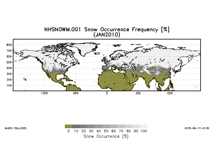
Northern Hemisphere Snow Cover Monthly Statistics at 1 Degree Resolution V001 (NHSNOWM) at GES DISC
National Aeronautics and Space Administration —
This product is Snow Cover Statistics. The dataset was prepared by Dr. Peter Romanov at Cooperative Institute for Climate Studies(CICS) of the University of Maryland... -
Federal
CERES Monthly Gridded Single Satellite Fluxes and Clouds TRMM Edition2C
National Aeronautics and Space Administration —
CER_FSW_TRMM-PFM-VIRS_Edition2C is the Clouds and the Earth's Radiant Energy System (CERES) Fixed Swath Width (FSW) Monthly Gridded Single Satellite Fluxes (SSF) and... -
Federal
MISR Level 3 Component Global Aerosol Product covering a quarter (seasonal) V004
National Aeronautics and Space Administration —
MIL3QAE_004 is the Multi-angle Imaging SpectroRadiometer (MISR) Level 3 Component Global Aerosol Product covering a quarter (seasonal) version 4. It contains a... -
Federal
MISR Level 3 Component Global Land Product covering a month V004
National Aeronautics and Space Administration —
MIL3MLS_004 is the Multi-angle Imaging SpectroRadiometer (MISR) Level 3 Component Global Land Product covering a month version 4. It contains a statistical summary of... -
Federal
MISR Level 3 Component Global Aerosol Product covering a year V004
National Aeronautics and Space Administration —
MIL3YAE_004 is the Multi-angle Imaging SpectroRadiometer (MISR) Level 3 Component Global Aerosol Product covering a year version 4 data product. It contains a... -
Federal
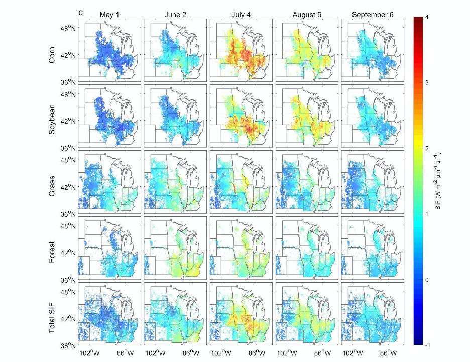
High Resolution Land Cover-Specific Solar-Induced Fluorescence, Midwestern USA, 2018
National Aeronautics and Space Administration —
This dataset provides estimated solar-induced chlorophyll fluorescence (SIF) of specific vegetation types and total SIF under clear-sky and real/cloudy conditions at... -
Federal
ASTER Level 1T Precision Terrain Corrected Registered At-Sensor Radiance V004
National Aeronautics and Space Administration —
The Terra Advanced Spaceborne Thermal Emission and Reflection Radiometer (ASTER) Level 1 Precision Terrain Corrected Registered At-Sensor Radiance (AST_L1T) data...

Official websites use .gov
A
.gov website belongs to an official government
organization in the United States.
Secure .gov websites use HTTPS
A
lock (
) or https:// means you’ve safely connected to
the .gov website. Share sensitive information only on official,
secure websites.