
-
Federal
ASTER Global Digital Elevation Model V003
National Aeronautics and Space Administration —
The Terra Advanced Spaceborne Thermal Emission and Reflection Radiometer (ASTER) Global Digital Elevation Model (GDEM) Version 3 (ASTGTM) provides a global digital... -
Federal
Millennium Ecosystem Assessment: MA Scenarios
National Aeronautics and Space Administration —
The Millennium Ecosystem Assessment: MA Scenarios provides data and information on population, income, cereal production and consumption, meat production and... -
Federal
Pre-LBA ABLE-2A and ABLE-2B Expedition Data
National Aeronautics and Space Administration —
The ABLE 2A and 2B (Atmospheric Boundary Layer Experiments) data consists of estimates of the rate of exchange of a wide variety of aerosols and gases between the... -
Federal
GHRSST NOAA/STAR GOES-16 ABI L2P America Region SST v2.70 dataset in GDS2
National Aeronautics and Space Administration —
GOES-16 (G16) is the first satellite in the US NOAA third generation of Geostationary Operational Environmental Satellites (GOES), a.k.a. GOES-R series (which will... -
Federal
CDAWeb FTP Site
National Aeronautics and Space Administration —
The CDAWeb data service (at http://cdaweb.gsfc.nasa.gov) offers graphic, listing, subsetting and data computation services for a continuously increasing database of... -
Federal
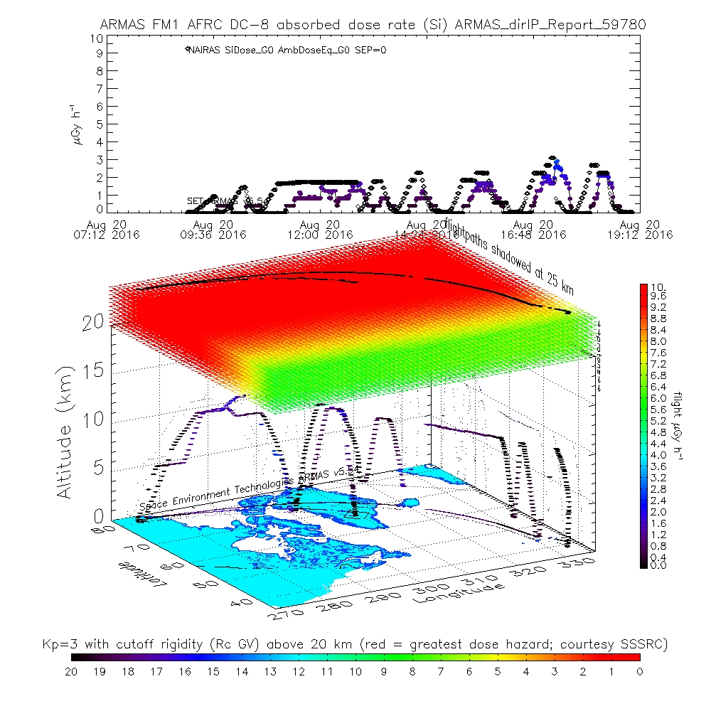
ATom: ARMAS Program Absorbed and Equivalent Radiation Dose Rates for ATom-1 Campaign
National Aeronautics and Space Administration —
This dataset contains Level 2 (L2) absorbed radiation dose rates in silicon from the Automated Radiation Measurements for Aerospace Safety (ARMAS) system along ATom... -
Federal
ASTER Global Emissivity Dataset, Monthly, 0.05 deg, HDF5 V041
National Aeronautics and Space Administration —
The Terra Advanced Spaceborne Thermal Emission and Reflection Radiometer (ASTER) Global Emissivity Dataset (GED) is a collection of monthly files (see known issues... -
Federal
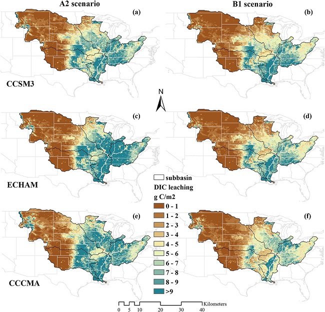
Export and Leaching of Carbon and Nitrogen from Mississippi River Basin, 1901-2099
National Aeronautics and Space Administration —
This dataset provides estimates for export and leaching of dissolved inorganic carbon (DIC), dissolved organic carbon (DIC), total organic carbon (TOC), particulate... -
Federal
SWOT Level 2 Water Mask Raster Image 100m Data Product, Version D
National Aeronautics and Space Administration —
The SWOT Level 2 KaRIn High Rate Raster Product (SWOT_L2_HR_Raster_D) provides rasterized estimates of water surface elevation, inundation extent, and radar... -
Federal
CAR Safari BRDF Measurements L1 V2 (CAR_SAFARI_BRDF) at GES DISC
National Aeronautics and Space Administration —
The Southern African Regional Science Initiative (SAFARI) 2000 is an international science field campaign aimed at developing a better understanding of the southern... -
Federal
CAR Safari South African Biogeophysics and Biogeochemistry L1 V1 (CAR_SAFARI_L1C) at GES DISC
National Aeronautics and Space Administration —
The Southern African Regional Science Initiative (SAFARI) 2000 is an international science field campaign aimed at developing a better understanding of the southern... -
Federal
ROSETTA-ORBITER STEINS GIADA 2 AST1 STEINSFLYBY V1.0
National Aeronautics and Space Administration —
The report provides the results from GIADA experiment during theRosetta Steins Flyby. Asteroid Steins was the first dedicated scientific target of the Rosetta... -
Federal
GHRSST NOAA/STAR Himawari-08 AHI L2P Pacific Ocean Region SST v2.70 dataset in GDS2
National Aeronautics and Space Administration —
Himawari-8 (H08) was launched on 7 October 2014 into its nominal position at 140.7-deg E, and declared operational on 7 July 2015. The Advanced Himawari Imager (AHI;... -
Federal
Multi-Mission Optimally Interpolated Sea Surface Salinity Global Dataset V2
National Aeronautics and Space Administration —
This is a level 4 product on a 0.25-degree spatial and 4-day temporal grid. The product is derived from the level 2 swath data of three satellite missions: the... -
Federal
Multi-Mission Optimally Interpolated Sea Surface Salinity Global Dataset V1
National Aeronautics and Space Administration —
This is a level 4 product on a 0.25-degree spatial and 4-day temporal grid. The product is derived from the level 2 swath data of three satellite missions: the... -
Federal
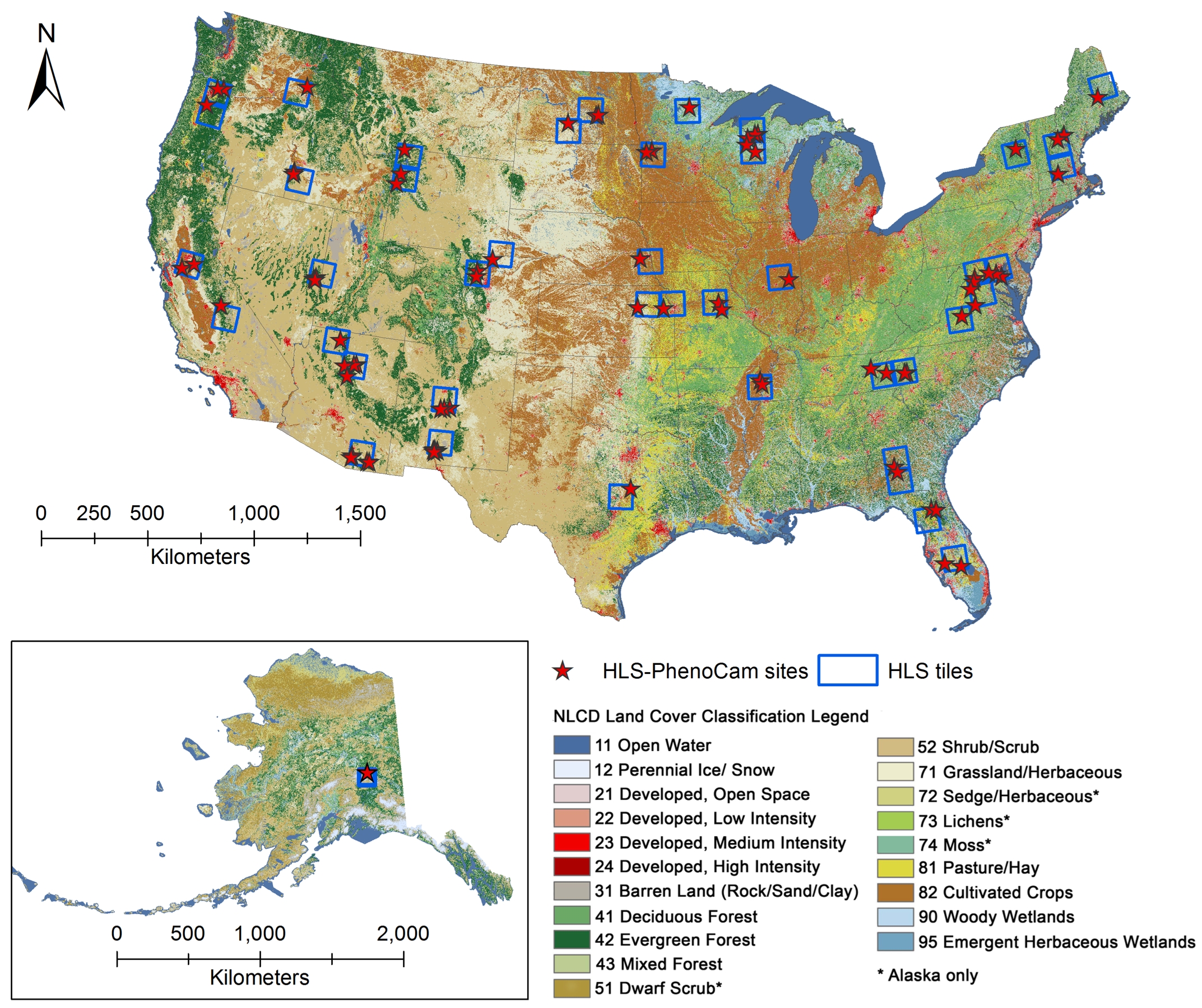
Phenology derived from Satellite Data and PhenoCam across CONUS and Alaska, 2019-2020
National Aeronautics and Space Administration —
This dataset provides a reference of land surface phenology (LSP) at 30-m pixels for 78 regions of 10 x 10 km2 across a wide range of ecological and climatic regions... -
Federal
Global Maps of Atmospheric Nitrogen Deposition, 1860, 1993, and 2050
National Aeronautics and Space Administration —
This data set provides global gridded estimates of atmospheric deposition of total inorganic nitrogen (N), NHx (NH3 and NH4+), and NOy (all oxidized forms of nitrogen... -
Federal
Delta-X: Island and Secondary Channel Model, MRD, LA, USA, 2022
National Aeronautics and Space Administration —
This dataset includes model code and output for a model that simulates changes in islands and small water channels of river delta systems in response to dynamics of...

Official websites use .gov
A
.gov website belongs to an official government
organization in the United States.
Secure .gov websites use HTTPS
A
lock (
) or https:// means you’ve safely connected to
the .gov website. Share sensitive information only on official,
secure websites.