
-
Federal
CMAPSS Jet Engine Simulated Data
National Aeronautics and Space Administration —
Data sets consists of multiple multivariate time series. Each data set is further divided into training and test subsets. Each time series is from a different engine... -
Federal
A Global Database of Gas Fluxes from Soils after Rewetting or Thawing, Version 1.0
National Aeronautics and Space Administration —
This database contains information compiled from published studies on gas flux from soil following rewetting or thawing. The resulting database includes 222 field and... -
Federal
Randomized Battery Usage 2: Room Temperature Random Walk
National Aeronautics and Space Administration —
This dataset is part of a series of datasets, where batteries are continuously cycled with randomly generated current profiles. Reference charging and discharging... -
Federal
VEMAP 2: U.S. Daily Climate Change Scenarios
National Aeronautics and Space Administration —
The Vegetation/Ecosystem Modeling and Analysis Project (VEMAP) Phase 2 has developed a number of transient climate change scenarios based on coupled atmosphere-ocean... -
Federal
GIBS Web Map Tile Service (WMTS)
National Aeronautics and Space Administration —
The WMTS implementation standard provides a standards-based solution for serviing digital maps using predefined image tiles. Through the constructs of the... -
Federal
Randomized Battery Usage 6: 40C Left Skewed Random Walk
National Aeronautics and Space Administration —
This dataset is part of a series of datasets, where batteries are continuously cycled with randomly generated current profiles. Reference charging and discharging... -
Federal
Randomized Battery Usage 5: High Temperature Right-Skewed Random Walk
National Aeronautics and Space Administration —
This dataset is part of a series of datasets, where batteries are continuously cycled with randomly generated current profiles. Reference charging and discharging... -
Federal
Global Hyperspectral Imaging Spectral-library of Agricultural crops for Conterminous United States V001
National Aeronautics and Space Administration —
The Global Hyperspectral Imaging Spectral-library of Agricultural crops (GHISA) is a comprehensive compilation, collation, harmonization, and standardization of... -
Federal
VEMAP 2: U.S. Annual Climate Change Scenarios
National Aeronautics and Space Administration —
The Vegetation/Ecosystem Modeling and Analysis Project (VEMAP) Phase 2 has developed a number of transient climate change scenarios based on coupled atmosphere-ocean... -
Federal
Randomized Battery Usage 3: Room Temperature Variable Recharge Random Walk
National Aeronautics and Space Administration —
This dataset is part of a series of datasets, where batteries are continuously cycled with randomly generated current profiles. Reference charging and discharging... -
Federal
Global 30-Year Mean Monthly Climatology, 1901-1960 (New et al.)
National Aeronautics and Space Administration —
This is a data set of 30-year mean monthly surface climate data over global land areas, excluding Antarctica, for the period 1901-1960. The data set is gridded at 0.5... -
Federal
A Global Database of Field-observed Leaf Area Index in Woody Plant Species, 1932-2011
National Aeronautics and Space Administration —
This data set provides global leaf area index (LAI) values for woody species. The data are a compilation of field-observed data from 1,216 locations obtained from 554... -
Federal
Annual Land Use and Urban Land Cover: Ethiopia, Nigeria, and South Africa, 2016-2020
National Aeronautics and Space Administration —
This dataset provides a two-tier annual Land Use (LU) and Urban Land Cover (LC) product suite over three African countries, Ethiopia, Nigeria, and South Africa,... -
Federal
NACP MsTMIP Summary of Model Structure and Characteristics
National Aeronautics and Space Administration —
This data set provides a summary of the model structure and characteristics of participating models in the North American Carbon Program (NACP) Multi-scale synthesis... -
Federal
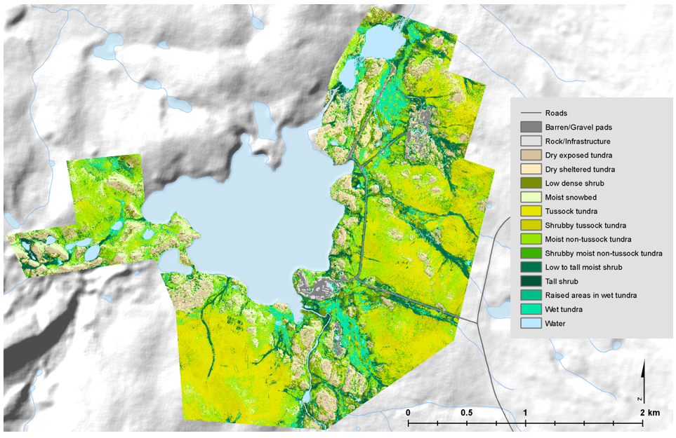
High-Resolution Vegetation Community Maps, Toolik Lake Area, Alaska, 2013-2015
National Aeronautics and Space Administration —
This dataset contains vegetation community maps at 20 cm resolution for three landscapes near the Toolik Lake research area in the northern foothills of the Brooks... -
Federal
NPP Multi-Biome: Summary Data from Intensive Studies at 125 Sites, 1936-2006
National Aeronautics and Space Administration —
This data set, NPP Multi-Biome: Summary Data from Intensive Studies at 125 Sites, 1936-2006, contains a single shapefile that provides site-level summary statistics... -
Federal
SORCE XPS Level 4 Solar Spectral Irradiance 1.0nm Res 24-Hour Means V012 (SOR4XPSD_LOW) at GES DISC
National Aeronautics and Space Administration —
The SORCE XPS Level 4 Solar Spectral Irradiance 1.0nm Res 24-Hour Means product (SOR4XPSD_LOW) contains modelled spectral extreme ultraviolet (XUV) irradiances based... -
Federal
SORCE XPS Level 4 Solar Spectral Irradiance 0.1nm Res 5-Minute V012 (SOR4XPS5) at GES DISC
National Aeronautics and Space Administration —
The SORCE XPS Level 4 Solar Spectral Irradiance 0.1nm Res 5-Minute product (SOR4XPS5) contains modelled spectral extreme ultraviolet (XUV) irradiances based on... -
Federal
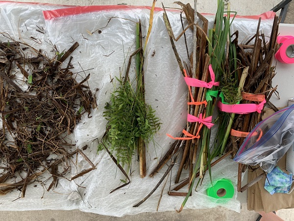
Delta-X: Aboveground Vegetation Structure, Herbaceous Wetlands, MRD, LA, USA, V2
National Aeronautics and Space Administration —
This dataset provides mean stem diameter, mean height, dominant species, hydrogeomorphic zone (HGM), and stem density for vegetation in herbaceous wetlands collected... -
Federal
MMR Ground Data (FIFE)
National Aeronautics and Space Administration —
Surface reflectance factors, radiances, and temperatures were measured with a Mast-borne Modular Multiband Radiometer (MMR), predominantly in the solar principal...

Official websites use .gov
A
.gov website belongs to an official government
organization in the United States.
Secure .gov websites use HTTPS
A
lock (
) or https:// means you’ve safely connected to
the .gov website. Share sensitive information only on official,
secure websites.