
-
Federal
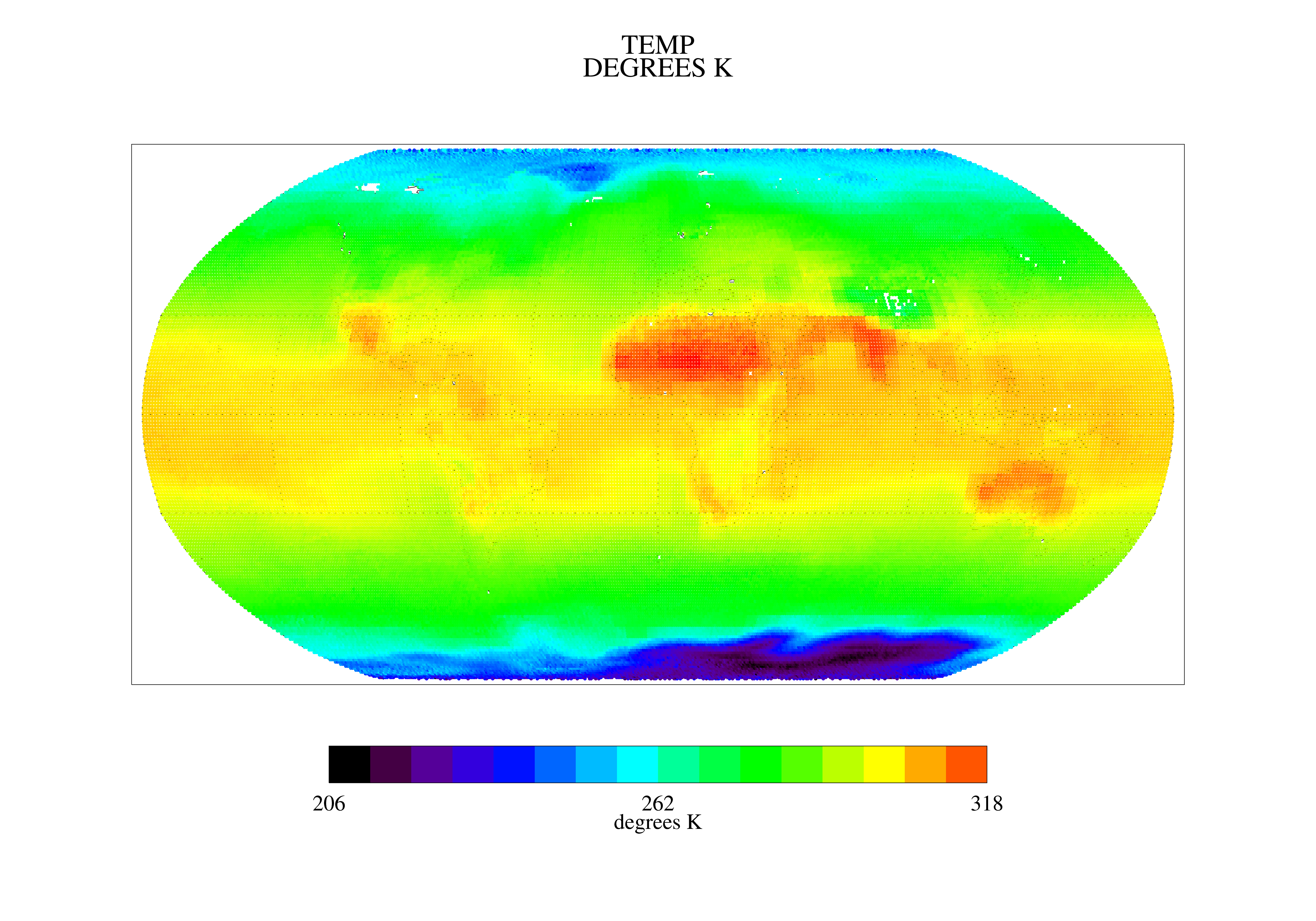
TOVS GLA MONTHLY GRIDS from NOAA-11 V01 (TOVSAMNH) at GES DISC
National Aeronautics and Space Administration —
This dataset (TOVSAMNH) contains the TIROS Operational Vertical Sounder (TOVS) level 3 geophysical parameters derived using data from NOAA-11 and the physical... -
Federal
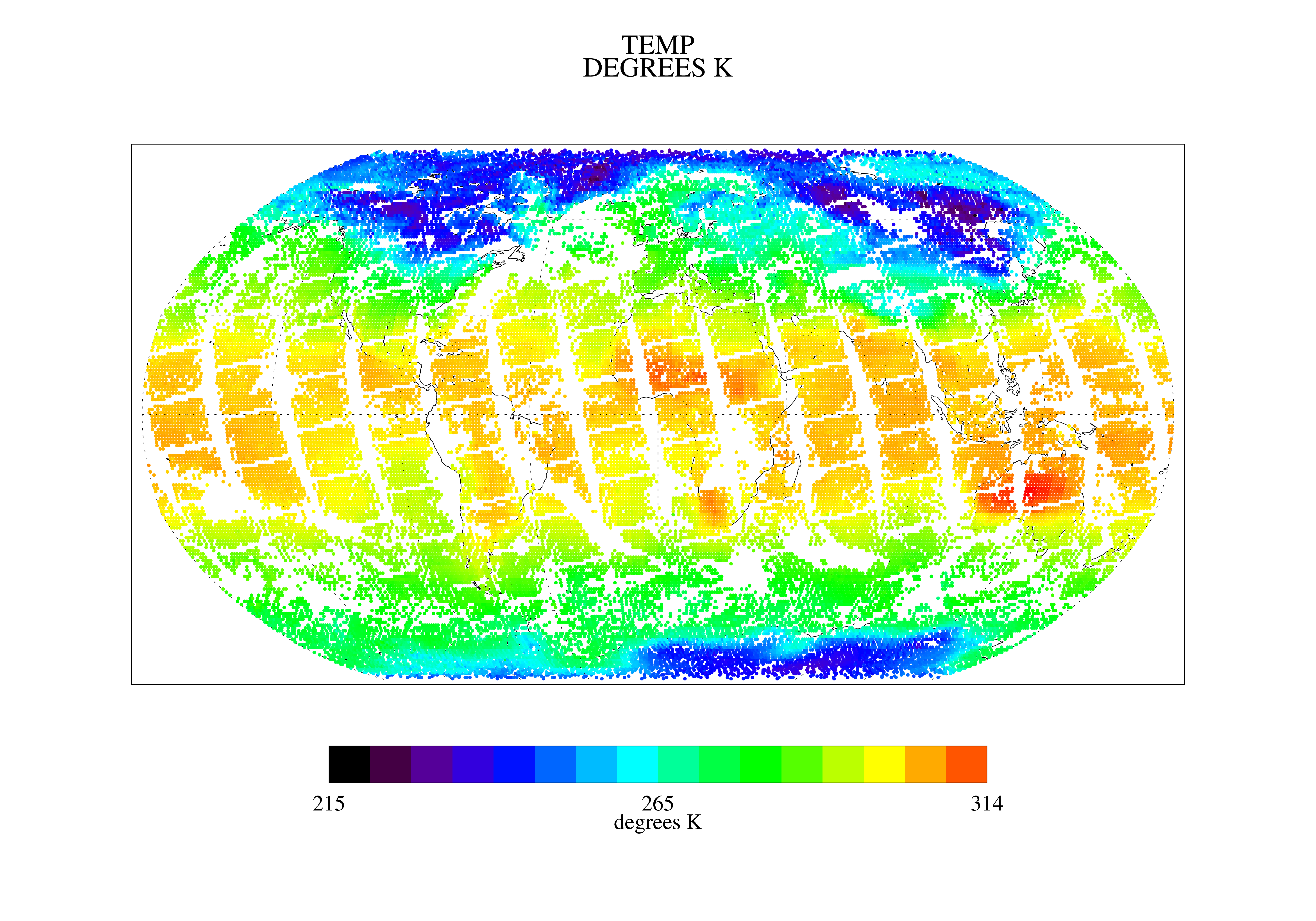
TOVS GLA 5 DAY GRIDS from NOAA-10 V01 (TOVSA5NG) at GES DISC
National Aeronautics and Space Administration —
This dataset (TOVSA5NG) contains the TIROS Operational Vertical Sounder (TOVS) level 3 geophysical parameters derived using data from NOAA-10 and the physical... -
Federal
EMIT L2B Estimated Mineral Identification and Band Depth and Uncertainty 60 m V001
National Aeronautics and Space Administration —
The Earth Surface Mineral Dust Source Investigation (EMIT) instrument measures surface mineralogy, targeting the Earth’s arid dust source regions. EMIT is installed... -
Federal
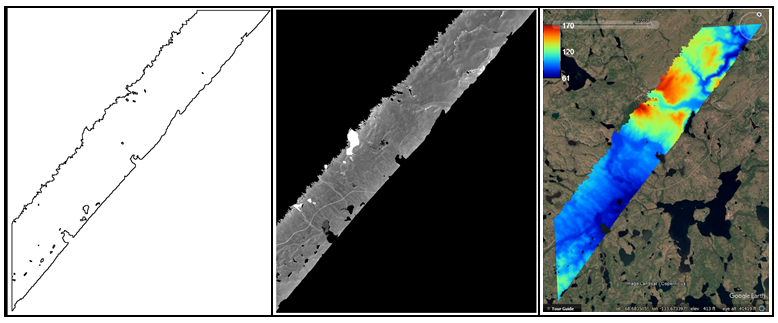
ABoVE: AirSWOT Ka-band Radar over Surface Waters of Alaska and Canada, 2017
National Aeronautics and Space Administration —
This dataset provides AirSWOT (Surface Water and Ocean Topography) Ka-band (35.75 GHz) radar data products collected from an airborne platform over parts of Alaska... -
Federal
EMIT L2A Estimated Surface Reflectance and Uncertainty and Masks 60 m V001
National Aeronautics and Space Administration —
The Earth Surface Mineral Dust Source Investigation (EMIT) instrument measures surface mineralogy, targeting the Earth’s arid dust source regions. EMIT is installed... -
Federal
TOVS GLA DAILY GRIDS from NOAA-11 V01 (TOVSADNH) at GES DISC
National Aeronautics and Space Administration —
This dataset (TOVSADNH) contains the TIROS Operational Vertical Sounder (TOVS) level 3 geophysical parameters derived using data from NOAA-11 and the physical... -
Federal
TOVS GLA DAILY GRIDS from TIROSN V01 (TOVSADTN) at GES DISC
National Aeronautics and Space Administration —
This dataset (TOVSADTN) contains the TIROS Operational Vertical Sounder (TOVS) level 3 geophysical parameters derived using data from TIROS-N and the physical... -
Federal
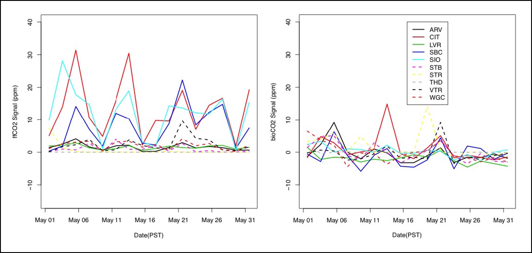
CMS: CO2 Signals Estimated for Fossil Fuel Emissions and Biosphere Flux, California
National Aeronautics and Space Administration —
This data set provides estimated CO2 emission signals for 16 regions (air quality basins) in California, USA, during the individual months of November 2010 and May... -
Federal
TOVS GLA DAILY GRIDS from NOAA-9 V01 (TOVSADNF) at GES DISC
National Aeronautics and Space Administration —
This dataset (TOVSADNF) contains the TIROS Operational Vertical Sounder (TOVS) level 3 geophysical parameters derived using data from NOAA-9 and the physical... -
Federal
TOVS GLA MONTHLY GRIDS from NOAA-9 V01 (TOVSAMNF) at GES DISC
National Aeronautics and Space Administration —
This dataset (TOVSAMNF) contains the TIROS Operational Vertical Sounder (TOVS) level 3 geophysical parameters derived using data from NOAA-9 and the physical... -
Federal
TOVS GLA 5 DAY GRIDS from NOAA-9 V01 (TOVSA5NF) at GES DISC
National Aeronautics and Space Administration —
This dataset (TOVSA5NF) contains the TIROS Operational Vertical Sounder (TOVS) level 3 geophysical parameters derived using data from NOAA-9 and the physical... -
Federal
EMIT L1B At-Sensor Calibrated Radiance and Geolocation Data 60 m V001
National Aeronautics and Space Administration —
The Earth Surface Mineral Dust Source Investigation (EMIT) instrument measures surface mineralogy, targeting the Earth’s arid dust source regions. EMIT is installed... -
Federal
TOVS GLA DAILY GRIDS from NOAA-12 V01 (TOVSADND) at GES DISC
National Aeronautics and Space Administration —
This dataset (TOVSADND) contains the TIROS Operational Vertical Sounder (TOVS) level 3 geophysical parameters derived using data from NOAA-12 and the physical... -
Federal
ABoVE: Passive Microwave-derived Annual Snowoff Date Maps, 1988-2018
National Aeronautics and Space Administration —
This dataset provides annual maps of the snowoff (SO) date from 1988-2018 across Alaska and parts of Far East Russia and northwest Canada at a resolution of 6.25 km.... -
Federal
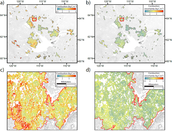
ABoVE: Wildfire Carbon Emissions and Burned Plot Characteristics, NWT, CA, 2014-2016
National Aeronautics and Space Administration —
This dataset provides estimates of wildfire carbon emissions and uncertainties at 30-m resolution, and measurements collected at burned and unburned field plots from... -
Federal
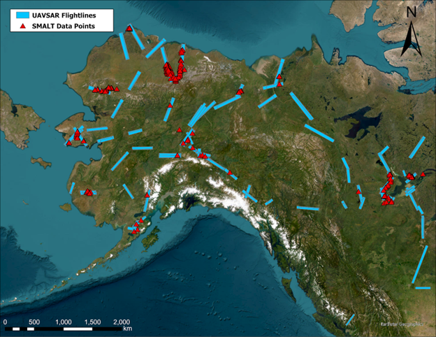
ABoVE: Soil Moisture and Active Layer Thickness in Alaska, USA and Canada, 2005-2022
National Aeronautics and Space Administration —
This dataset provides soil thaw depth and moisture measurements and dielectric properties measured by different research teams at sites in Alaska, U.S., and the... -
Federal
TOVS GLA 5 DAY GRIDS from NOAA-12 V01 (TOVSA5ND) at GES DISC
National Aeronautics and Space Administration —
This dataset (TOVSA5ND) contains the TIROS Operational Vertical Sounder (TOVS) level 3 geophysical parameters derived using data from NOAA-12 and the physical... -
Federal
TOVS GLA 5 DAY GRIDS from NOAA-11 V01 (TOVSA5NH) at GES DISC
National Aeronautics and Space Administration —
This dataset (TOVSA5NH) contains the TIROS Operational Vertical Sounder (TOVS) level 3 geophysical parameters derived using data from NOAA-11 and the physical... -
Federal
TOVS GLA MONTHLY GRIDS from TIROSN V01 (TOVSAMTN) at GES DISC
National Aeronautics and Space Administration —
This dataset (TOVSAMTN) contains the TIROS Operational Vertical Sounder (TOVS) level 3 geophysical parameters derived using data from TIROSN and the physical...

Official websites use .gov
A
.gov website belongs to an official government
organization in the United States.
Secure .gov websites use HTTPS
A
lock (
) or https:// means you’ve safely connected to
the .gov website. Share sensitive information only on official,
secure websites.